Category:Bonby
Jump to navigation
Jump to search
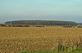
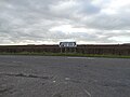
English: Bonby is a village and civil parish in North Lincolnshire, England, about five miles south of Barton-upon-Humber. According to the 2001 census it had a population of 481.
village in the United Kingdom  | |||||
| Upload media | |||||
| Instance of | |||||
|---|---|---|---|---|---|
| Location | North Lincolnshire, Lincolnshire, Yorkshire and the Humber, England | ||||
 | |||||
Subcategories
This category has the following 16 subcategories, out of 16 total.
A
B
- Bio Waste Solutions, Bonby (4 F)
- Bonby War Memorial (3 F)
C
- Carr Lane, Bonby (10 F)
D
- Drainage in Bonby (6 F)
F
- Fingerposts in Bonby (4 F)
- Forests in Bonby (7 F)
H
- The Haymaker, Bonby (5 F)
- Hedges in Bonby (16 F)
P
- Public footpaths in Bonby (5 F)
S
T
- Trees in Bonby (18 F)
Media in category "Bonby"
The following 200 files are in this category, out of 251 total.
(previous page) (next page)-
 "Godfrey" boundary marker above Bonby - geograph.org.uk - 4836860.jpg 5,184 × 3,888; 6.73 MB
-
 A farm track at Bonby Carrs - geograph.org.uk - 2168072.jpg 800 × 600; 269 KB
-
 A farm track off the B1204 near Bonby - geograph.org.uk - 2342624.jpg 800 × 600; 284 KB
-
 A farm track towards Bonby Carrs - geograph.org.uk - 2168060.jpg 800 × 600; 233 KB
-
 A15 - geograph.org.uk - 5355785.jpg 640 × 387; 37 KB
-
 A15 and slip road looking south - geograph.org.uk - 2529288.jpg 1,600 × 1,200; 223 KB
-
 A15 Bonby Lodge Interchange - geograph.org.uk - 2053000.jpg 1,000 × 750; 520 KB
-
 Agricultural Storage Buildings near Bonby - geograph.org.uk - 3235187.jpg 1,500 × 1,125; 1.76 MB
-
 Appleby, aerial 2019 - geograph.org.uk - 6197417.jpg 800 × 533; 106 KB
-
 Approaching Bonby from the south - geograph.org.uk - 4899907.jpg 640 × 480; 328 KB
-
 At the crossroads above Bonby - geograph.org.uk - 4836866.jpg 4,819 × 3,511; 4.41 MB
-
 Autumn Cultivation near Bonby Top - geograph.org.uk - 3169592.jpg 1,500 × 1,006; 1.61 MB
-
 B1204 through Bonby - geograph.org.uk - 3011057.jpg 640 × 439; 54 KB
-
 B1204 towards Bonby - geograph.org.uk - 5113341.jpg 4,382 × 2,897; 4.53 MB
-
 B1206 heading north - geograph.org.uk - 2529278.jpg 1,600 × 1,200; 347 KB
-
 B1218 - B1206 road junction - geograph.org.uk - 2048428.jpg 800 × 600; 208 KB
-
 B1218 near Beaumontcote Farm - geograph.org.uk - 1855465.jpg 845 × 750; 772 KB
-

-
 Barn near Bonby - geograph.org.uk - 3653487.jpg 1,600 × 1,200; 1.58 MB
-
 Barricades at end of Bonby Carr Lane - geograph.org.uk - 6270633.jpg 5,120 × 2,226; 2.75 MB
-
 Beet Harvesting near Bonby Top Farm - geograph.org.uk - 3750763.jpg 1,600 × 1,081; 728 KB
-
 Bench alongside the B1204 Saxby Road - geograph.org.uk - 4929536.jpg 1,024 × 768; 126 KB
-
 Bennett's New Covert - geograph.org.uk - 2162173.jpg 1,280 × 836; 1.01 MB
-
 Biofuel Transport near Bonby - geograph.org.uk - 1842436.jpg 640 × 397; 233 KB
-
 Bonby - geograph.org.uk - 2620186.jpg 640 × 427; 64 KB
-
 Bonby Building site Tinkers Corner - geograph.org.uk - 2620174.jpg 640 × 427; 92 KB
-
 Bonby Building site Tinkers Corner - geograph.org.uk - 2620179.jpg 640 × 427; 106 KB
-
 Bonby Building site Tinkers Corner - geograph.org.uk - 2620181.jpg 640 × 427; 108 KB
-
 Bonby Carr Lane (track) - geograph.org.uk - 2528135.jpg 1,600 × 1,200; 597 KB
-
 Bonby Carr Lane (track) - geograph.org.uk - 2528149.jpg 1,600 × 1,200; 565 KB
-
 Bonby Carr Lane - geograph.org.uk - 2017947.jpg 1,024 × 768; 168 KB
-
 Bonby Carr Lane - geograph.org.uk - 6270637.jpg 3,648 × 1,586; 2.02 MB
-
 Bonby Carr Lane - geograph.org.uk - 6270639.jpg 3,398 × 1,587; 1.53 MB
-

-
 Bonby Carr Lane towards Carr Lane - geograph.org.uk - 5668696.jpg 1,600 × 1,064; 1.02 MB
-
 Bonby Carr Lane towards Carr Lane - geograph.org.uk - 5668699.jpg 1,600 × 1,064; 953 KB
-
 Bonby Carr Lane towards Carr Lane - geograph.org.uk - 5668704.jpg 1,600 × 1,064; 956 KB
-
 Bonby Carr Lane towards Carr Lane - geograph.org.uk - 5668705.jpg 1,600 × 1,064; 784 KB
-
 Bonby Carrs - geograph.org.uk - 2017930.jpg 1,024 × 768; 157 KB
-
 Bonby Carrs - geograph.org.uk - 6270655.jpg 3,648 × 1,586; 1.77 MB
-
 Bonby Carrs - geograph.org.uk - 6270656.jpg 3,638 × 1,596; 2.41 MB
-
 Bonby Carrs by Bonby Catchwater Drain - geograph.org.uk - 6270658.jpg 3,648 × 1,593; 1.87 MB
-
 Bonby Carrs, aerial 2018 - geograph.org.uk - 5769089.jpg 533 × 800; 58 KB
-
 Bonby Catchwater - geograph.org.uk - 6271656.jpg 1,024 × 768; 229 KB
-
 Bonby Catchwater Drain - geograph.org.uk - 2017847.jpg 1,024 × 768; 222 KB
-
 Bonby Lodge - geograph.org.uk - 2035457.jpg 1,000 × 634; 565 KB
-
 Bonby Lodge - geograph.org.uk - 2162215.jpg 1,280 × 851; 1.29 MB
-
 Bonby Main Junction - geograph.org.uk - 2620192.jpg 640 × 427; 69 KB
-
 Bonby Methodist chapel - geograph.org.uk - 2017830.jpg 1,024 × 768; 161 KB
-
 Bonby Road towards Barrow-upon-Humber - geograph.org.uk - 2048416.jpg 800 × 600; 163 KB
-
 Bonby Sheepdyke Lane - geograph.org.uk - 2620190.jpg 640 × 427; 63 KB
-
 Bonby Top - geograph.org.uk - 2315486.jpg 640 × 427; 86 KB
-
 Bonby Top - geograph.org.uk - 2315489.jpg 640 × 427; 87 KB
-
 Bonby turn-off from the A15 - geograph.org.uk - 3877524.jpg 640 × 427; 53 KB
-
 Bonby Vicarage and Church, 1916.jpg 1,012 × 616; 455 KB
-
 Bonby Village Hall - geograph.org.uk - 2018453.jpg 1,024 × 768; 120 KB
-
 Bonby village post office - geograph.org.uk - 4929525.jpg 1,024 × 629; 130 KB
-

-
 Bridge on Carr Lane, Bonby Carrs - geograph.org.uk - 5667476.jpg 1,600 × 1,064; 704 KB
-

-
 Carr Lane - geograph.org.uk - 2528112.jpg 1,600 × 1,200; 409 KB
-
 Carr Lane - geograph.org.uk - 2528118.jpg 1,600 × 1,200; 370 KB
-
 Carr Lane - geograph.org.uk - 2528127.jpg 1,600 × 1,200; 380 KB
-
 Carr Lane - geograph.org.uk - 3935324.jpg 1,024 × 683; 241 KB
-
 Carr Lane - geograph.org.uk - 3935328.jpg 1,024 × 683; 215 KB
-
 Carr Lane towards Bonby - geograph.org.uk - 5668842.jpg 1,600 × 1,064; 711 KB
-
 Carr Lane towards Bonby - geograph.org.uk - 5668847.jpg 1,600 × 1,064; 654 KB
-
 Carr Lane towards Bonby - geograph.org.uk - 5668859.jpg 1,600 × 1,064; 777 KB
-
 Carr Lane, Bonby - geograph.org.uk - 5556243.jpg 640 × 427; 78 KB
-
 Carr Lane, Bonby - geograph.org.uk - 5556244.jpg 640 × 427; 63 KB
-

-
 Church Lane down to Bonby - geograph.org.uk - 3341328.jpg 1,500 × 996; 1.2 MB
-
 Church Lane towards Bonby - geograph.org.uk - 2528074.jpg 1,600 × 1,200; 447 KB
-
 Church Lane, Bonby - geograph.org.uk - 2017834.jpg 1,024 × 768; 215 KB
-
 Church Lane, Bonby - geograph.org.uk - 2081334.jpg 800 × 600; 280 KB
-
 Combining near Bonby - geograph.org.uk - 2561189.jpg 1,280 × 960; 918 KB
-
 Combining near Bonby - geograph.org.uk - 2561202.jpg 1,280 × 960; 844 KB
-
 Compost bins - geograph.org.uk - 2526420.jpg 1,024 × 768; 139 KB
-
 Cool picnic site - geograph.org.uk - 6270652.jpg 3,648 × 1,744; 3.68 MB
-
 Crop field, Saxby Wold - geograph.org.uk - 2528065.jpg 1,600 × 1,200; 506 KB
-

-
 Cropmarks on Saxby Wolds, aerial 2019 (2) - geograph.org.uk - 6352038.jpg 1,024 × 683; 100 KB
-
 Cross Roads near Bonby - geograph.org.uk - 3660700.jpg 1,600 × 1,189; 1.31 MB
-
 Cutting Miscanthus near Bonby - geograph.org.uk - 4341532.jpg 1,600 × 1,173; 1.69 MB
-
 Cutting the miscanthus by the lane to Bonby - geograph.org.uk - 3877527.jpg 1,024 × 683; 128 KB
-

-
 Dark Clouds over Brigg - geograph.org.uk - 1965332.jpg 1,000 × 665; 544 KB
-
 Digging Pipe Trench near Bonby - geograph.org.uk - 3689602.jpg 1,600 × 1,564; 2.02 MB
-
 Disused Bonby Methodist Church - geograph.org.uk - 5556242.jpg 640 × 427; 80 KB
-
 Disused section of the B1206 - geograph.org.uk - 2426342.jpg 1,024 × 768; 99 KB
-
 Drying Miscanthus Crop - geograph.org.uk - 2310244.jpg 960 × 1,280; 1.46 MB
-
 Edge of Miscanthus Field - geograph.org.uk - 3209113.jpg 640 × 425; 97 KB
-
 Edge of Miscanthus Field - geograph.org.uk - 3235219.jpg 1,500 × 799; 1.38 MB
-
 Edge of Miscanthus Field near Bonby - geograph.org.uk - 2150993.jpg 1,280 × 960; 1.47 MB
-
 Electricity Transformer - geograph.org.uk - 3657413.jpg 1,261 × 1,600; 1.61 MB
-
 End of Bonby Car Lane - geograph.org.uk - 6270636.jpg 3,648 × 1,588; 1.78 MB
-
 Entering Bonby, Lincolnshire - geograph.org.uk - 2342617.jpg 800 × 600; 208 KB
-
 Entrance to Bonby House - geograph.org.uk - 2017840.jpg 1,024 × 768; 228 KB
-
 Exposed bench - geograph.org.uk - 2017858.jpg 1,024 × 768; 178 KB
-
 Farm Buildings and Storage Tank on Middlegate - geograph.org.uk - 3209102.jpg 1,500 × 996; 1.28 MB
-

-

-
 Farm track near Bonby Lodge - geograph.org.uk - 4900004.jpg 512 × 640; 418 KB
-
 Farm track off Carr Lane - geograph.org.uk - 2528130.jpg 1,600 × 1,200; 409 KB
-
 Farm track on Bonby Carrs - geograph.org.uk - 5668863.jpg 1,600 × 1,064; 528 KB
-
 Farm track, Bonby Carrs - geograph.org.uk - 2017915.jpg 1,024 × 768; 147 KB
-
 Farm track, Bonby Carrs - geograph.org.uk - 6271663.jpg 1,024 × 768; 217 KB
-
 Farmland off Bonby Carr Lane - geograph.org.uk - 2528139.jpg 1,600 × 1,189; 454 KB
-
 Farmland off Carr Lane - geograph.org.uk - 2528109.jpg 1,600 × 1,200; 451 KB
-
 Farmland off Middlegate Road - geograph.org.uk - 2528090.jpg 1,600 × 1,200; 389 KB
-
 Farmland off the B1206 - geograph.org.uk - 2529276.jpg 1,600 × 1,200; 359 KB
-
 Farmland, Bonby Carrs - geograph.org.uk - 2528125.jpg 1,600 × 1,200; 440 KB
-
 Farmland, Bonby Carrs - geograph.org.uk - 2528132.jpg 1,600 × 1,200; 425 KB
-
 Field Boundary near Bonby - geograph.org.uk - 3239509.jpg 1,125 × 1,500; 1.76 MB
-
 Field Boundary near Bonby - geograph.org.uk - 3683850.jpg 1,600 × 1,200; 1.39 MB
-
 Field Scabious - geograph.org.uk - 1992208.jpg 1,000 × 890; 640 KB
-
 First Poppies - geograph.org.uk - 1898058.jpg 1,000 × 962; 1.34 MB
-

-
 Footpath off Middlegate Road - geograph.org.uk - 2528083.jpg 1,600 × 1,200; 480 KB
-
 Former fuel source - geograph.org.uk - 2526407.jpg 1,024 × 768; 273 KB
-
 Fox Covert Plantation - geograph.org.uk - 2404615.jpg 1,280 × 956; 1.17 MB
-
 Fussey Gardens, Bonby - geograph.org.uk - 2017812.jpg 1,024 × 768; 118 KB
-
 GODFREY, post on Worlaby New Ings - geograph.org.uk - 5556440.jpg 427 × 640; 97 KB
-
 Gorse - geograph.org.uk - 3902504.jpg 3,610 × 2,669; 5.91 MB
-
 Group of trees on Bonby Carrs - geograph.org.uk - 5556497.jpg 640 × 427; 67 KB
-
 Hall Farm - geograph.org.uk - 2311927.jpg 640 × 427; 71 KB
-
 Hard track across Bonby Carrs - geograph.org.uk - 5556500.jpg 427 × 640; 109 KB
-
 Harvested Field near Bonby - geograph.org.uk - 3148438.jpg 1,500 × 1,125; 1.38 MB
-
 Harvesting near Bonby - geograph.org.uk - 4166174.jpg 1,600 × 1,110; 1.28 MB
-
 Hawkweed by Carr Lane, Bonby - geograph.org.uk - 5556281.jpg 640 × 427; 91 KB
-
 Highway Boundary Marker near Bonby - geograph.org.uk - 2434614.jpg 1,280 × 960; 1.16 MB
-
 Irrigating Potatoes near Bonby - geograph.org.uk - 2428692.jpg 1,280 × 870; 963 KB
-
 Land Drain off Carr Lane - geograph.org.uk - 2528115.jpg 1,600 × 1,200; 511 KB
-
 Land Drain, Bonby Carrs - geograph.org.uk - 6271660.jpg 1,024 × 768; 213 KB
-
 Lane junction near Bonby - geograph.org.uk - 5096242.jpg 800 × 566; 67 KB
-
 Lay-by on the old road - geograph.org.uk - 6415491.jpg 1,024 × 768; 127 KB
-
 Lay-by, formerly part of B1206 - geograph.org.uk - 6125170.jpg 3,648 × 1,993; 1.51 MB
-
 Loading Muck near Bonby - geograph.org.uk - 3158499.jpg 1,500 × 1,057; 1.3 MB
-

-
 Looking across the River Ancholme, Bonby Carrs - geograph.org.uk - 2017941.jpg 1,024 × 768; 165 KB
-

-
 Looking towards Bonby Carrs - geograph.org.uk - 2017798.jpg 1,024 × 768; 219 KB
-
 Looking towards Bonby Carrs - geograph.org.uk - 2168066.jpg 800 × 600; 260 KB
-
 Looking towards Scunthorpe - geograph.org.uk - 2410116.jpg 1,280 × 960; 1.27 MB
-
 Main Street, Bonby - geograph.org.uk - 5113512.jpg 1,600 × 972; 337 KB
-
 Main Street, Bonby - geograph.org.uk - 6270413.jpg 3,626 × 1,579; 1.54 MB
-
 Main Street, Bonby - geograph.org.uk - 794385.jpg 640 × 469; 113 KB
-
 Manor Farm - geograph.org.uk - 2161875.jpg 1,280 × 883; 1.25 MB
-
 Marsh grazing by Bonby Carr Lane - geograph.org.uk - 5556286.jpg 640 × 427; 76 KB
-

-

-
 Middlegate Lane - geograph.org.uk - 6271648.jpg 1,024 × 768; 173 KB
-
 Middlegate Lane, Bonby - geograph.org.uk - 6270420.jpg 3,648 × 1,744; 1.7 MB
-
 Middlegate near Bonby - geograph.org.uk - 2211678.jpg 1,280 × 960; 1.02 MB
-
 Middlegate near Bonby - geograph.org.uk - 2310230.jpg 1,280 × 960; 1.09 MB
-
 Middlegate near Bonby - geograph.org.uk - 3169675.jpg 1,500 × 1,125; 1.59 MB
-
 Middlegate near Bonby - geograph.org.uk - 3209106.jpg 1,500 × 996; 1.26 MB
-
 Middlegate near Bonby Top Farm - geograph.org.uk - 3388003.jpg 1,500 × 1,125; 1.39 MB
-
 Middlegate Road near Bonby - geograph.org.uk - 4899917.jpg 640 × 480; 367 KB
-
 Minor road to Barrow-upon-Humber - geograph.org.uk - 2032032.jpg 800 × 600; 250 KB
-
 Minor road towards the A15 - geograph.org.uk - 2528068.jpg 1,600 × 1,200; 426 KB
-
 Miscanthus and Middlegate Road - geograph.org.uk - 2608362.jpg 1,024 × 768; 156 KB
-
 Miscanthus and the Vale of Ancholme - geograph.org.uk - 2608350.jpg 1,024 × 768; 177 KB
-
 Miscanthus Bales - geograph.org.uk - 1826446.jpg 1,000 × 750; 665 KB
-
 Miscanthus Bales - geograph.org.uk - 3450857.jpg 1,500 × 1,125; 696 KB
-
 Miscanthus Bio-fuel Crop - geograph.org.uk - 2678471.jpg 1,280 × 960; 1.33 MB
-
 Miscanthus Crop in November - geograph.org.uk - 2162198.jpg 1,280 × 948; 1.27 MB
-
 Miscanthus Crop near Bonby - geograph.org.uk - 1943781.jpg 1,000 × 750; 772 KB
-
 Miscanthus Crop near Bonby - geograph.org.uk - 3156557.jpg 1,500 × 996; 1.92 MB
-
 Miscanthus Field near Bonby - geograph.org.uk - 2410141.jpg 1,280 × 1,280; 1.19 MB
-
 Miscanthus Field near Bonby Lodge - geograph.org.uk - 2041170.jpg 1,000 × 664; 130 KB
-
 Miscanthus Grass near Bonby - geograph.org.uk - 2103547.jpg 1,280 × 1,389; 1.52 MB
-
 Mowing on Bonby Carrs - geograph.org.uk - 6270646.jpg 3,212 × 1,551; 1.18 MB
-
 Mown Miscanthus Field - geograph.org.uk - 3407478.jpg 1,500 × 981; 696 KB
-
 Muck Spreading near Bonby - geograph.org.uk - 3158467.jpg 1,500 × 1,125; 1.82 MB
-
 Murky January Afternoon Near Bonby - geograph.org.uk - 3292188.jpg 1,500 × 1,125; 1.31 MB
-
 Near Bonby - geograph.org.uk - 4510540.jpg 1,415 × 1,600; 2.77 MB
-
 Near Bonby Top Farm - geograph.org.uk - 1893267.jpg 1,000 × 726; 764 KB
-
 Near Bonby Top Farm - geograph.org.uk - 3252610.jpg 1,125 × 1,500; 1.56 MB
-

-
 Oilseed rape - geograph.org.uk - 3935354.jpg 1,024 × 683; 261 KB
-
 Old Chapel, Bonby - geograph.org.uk - 6270410.jpg 2,773 × 1,577; 1.4 MB
-
 On Bonby Carrs - geograph.org.uk - 6270641.jpg 3,301 × 1,545; 1.68 MB
-
 On Middlegate Road near Bonby Top - geograph.org.uk - 4836858.jpg 5,184 × 3,888; 5.47 MB
-
 Planting Miscanthus - geograph.org.uk - 2862780.jpg 1,280 × 960; 909 KB
-
 Pollination - geograph.org.uk - 2471650.jpg 1,280 × 1,280; 997 KB
-
 Potato Harvesting near Grange Farm, Bonby - geograph.org.uk - 2652472.jpg 1,280 × 886; 1.16 MB
-
 Potato Lifting near Bonby Top Farm - geograph.org.uk - 2615671.jpg 1,280 × 697; 928 KB
-
 Preparing Potato Beds near Bonby - geograph.org.uk - 2323838.jpg 1,280 × 960; 1.28 MB
-
 Public Footpath down to Bonby - geograph.org.uk - 2011215.jpg 750 × 1,000; 859 KB
-
 Public Footpath to Bonby - geograph.org.uk - 2992716.jpg 1,500 × 1,125; 1.53 MB
-
 Public Footpath to Bonby - geograph.org.uk - 2993253.jpg 1,500 × 1,327; 1.94 MB
-
 Rainbow over Bonby Carrs - geograph.org.uk - 2035752.jpg 1,024 × 768; 106 KB
-
 Recycling plant near Bonby - geograph.org.uk - 6418249.jpg 1,024 × 722; 714 KB
-
 Rising ground with woodland near Bonby - geograph.org.uk - 5113389.jpg 4,676 × 2,704; 6.26 MB
-
 Road from Bonby to the A15 - geograph.org.uk - 5058463.jpg 640 × 427; 37 KB
-
 Road junction near Bonby Lodge - geograph.org.uk - 4837087.jpg 5,184 × 3,888; 5.01 MB
-
 Rough pasture north off Carr Lane - geograph.org.uk - 2528124.jpg 1,600 × 1,200; 483 KB
-
 Saxby road north of Bonby - geograph.org.uk - 3011058.jpg 640 × 447; 40 KB
-
 Saxby Wold - geograph.org.uk - 2404584.jpg 1,280 × 956; 1.14 MB


_-_geograph.org.uk_-_2528135.jpg)
_-_geograph.org.uk_-_2528149.jpg)


_-_geograph.org.uk_-_6352039.jpg)
_-_geograph.org.uk_-_6352038.jpg)


