Category:Bodenmühlwand
Jump to navigation
Jump to search
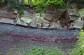
Die sogenannte „Rote Wand“ ist eines der lohnendsten Ausflugsziele für geologisch Interessierte in Nordbayern. Sie liegt im Tal des Roten Mains, nahe der Bodenmühle unweit von Bayreuth. Der etwa 30 Meter hohe geologische Aufschluss ist einer der besten im mittleren Keuper Frankens. Die oberste Schicht, auf der Bäume wachsen, besteht aus Schilfsandstein. Darunter folgen Tonsteine mit Mergelbänkchen, die sogenannten Estherienschichten. Das gesamte Schichtpaket ist mit 10 Grad nach Westen gekippt. Am Fuße dieses geologischen Aufschlusses fließt der Rote Main in Richtung Bayreuth.
Geosite and outcrop (river cutbank) of the Middle Keuper near Bayreuth, Bavaria .jpg) | |||||
| Upload media | |||||
| Instance of | |||||
|---|---|---|---|---|---|
| Location | Bayreuth, Upper Franconia, Bavaria, Germany | ||||
| Width |
| ||||
| Length |
| ||||
| Area |
| ||||
| Elevation above sea level |
| ||||
| official website | |||||
 | |||||
Media in category "Bodenmühlwand"
The following 8 files are in this category, out of 8 total.
-
 Bodenmühlwand im Rotmaintal.jpg 1,600 × 1,200; 1.57 MB
-
 Bodenmühlwand (01).jpg 4,928 × 3,264; 11.01 MB
-
 Bodenmühlwand (02).jpg 3,264 × 4,928; 9.92 MB
-
 Bodenmühlwand (03).jpg 4,928 × 3,264; 11.93 MB
-
 Bodenmühlwand (04).jpg 3,264 × 4,928; 11.58 MB
-
 Bodenmühlwand (05).jpg 4,928 × 3,264; 10.32 MB
-
 Bodenmühlwand (06).jpg 4,928 × 3,264; 9.39 MB
-
 Bodenmühlwand Roter Main (3).JPG 6,000 × 4,000; 22.38 MB

.jpg)
.jpg)
.jpg)
.jpg)
.jpg)
.JPG)