Category:Bletchingley
Jump to navigation
Jump to search
English: Bletchingley (or Blechingley) is a village in Surrey, England. It is on the A25 road to the east of Redhill and to the west of Godstone.
village and civil parish in Surrey, United Kingdom  | |||||
| Upload media | |||||
| Instance of | |||||
|---|---|---|---|---|---|
| Location | Tandridge, Surrey, South East England, England | ||||
| Area |
| ||||
| Said to be the same as | Bletchingley (Wikimedia duplicated page, civil parish) | ||||
| official website | |||||
 | |||||
Subcategories
This category has the following 7 subcategories, out of 7 total.
B
- Bletchingley Tunnel (5 F)
- Brewer Street Farm House (2 F)
P
- Pendell House (1 F)
T
- The Hawthorns Pendell Court (2 F)
W
- Warwick Wold (2 F)
- The Whyte Harte Hotel (4 F)
Media in category "Bletchingley"
The following 200 files are in this category, out of 535 total.
(previous page) (next page)-
 21 and 25 - geograph.org.uk - 2256251.jpg 640 × 480; 141 KB
-
 23-27 High Street - geograph.org.uk - 3354096.jpg 640 × 425; 337 KB
-
 26 - 30 High Street - geograph.org.uk - 2746228.jpg 640 × 425; 89 KB
-
 3 - 9 High Street - geograph.org.uk - 3353074.jpg 640 × 425; 308 KB
-
 32 - 46 High Street - geograph.org.uk - 2746254.jpg 640 × 425; 88 KB
-
 36 - 46 High Street - geograph.org.uk - 2746278.jpg 640 × 425; 98 KB
-
 4 layers of roads - geograph.org.uk - 2428118.jpg 640 × 393; 33 KB
-
 48 - 58 High Street - geograph.org.uk - 2747078.jpg 640 × 425; 77 KB
-
 48 and 50 High Street - geograph.org.uk - 2746957.jpg 640 × 425; 99 KB
-
 80 - 96 High Street - geograph.org.uk - 2747097.jpg 640 × 425; 87 KB
-
 A high bridge over M23 - geograph.org.uk - 1175496.jpg 640 × 479; 58 KB
-
 A lane crossways - geograph.org.uk - 2240495.jpg 640 × 480; 151 KB
-
 A lot of concrete^ - geograph.org.uk - 2428124.jpg 640 × 430; 41 KB
-
 A Pond near Pendell Court - geograph.org.uk - 51131.jpg 640 × 480; 174 KB
-
 A25 High Street, Bletchingley - geograph.org.uk - 6200459.jpg 1,024 × 684; 314 KB
-
 Anti-clockwise M25 - geograph.org.uk - 3731958.jpg 640 × 480; 247 KB
-

-

-

-
 Anti-clockwise M25, Merstham Interchange - geograph.org.uk - 3731941.jpg 640 × 480; 252 KB
-
 Archi-texture - geograph.org.uk - 1944622.jpg 2,829 × 3,450; 4.71 MB
-
 Autumnal tree near South Park - geograph.org.uk - 3187294.jpg 1,024 × 768; 668 KB
-
 Barfields - geograph.org.uk - 1564726.jpg 640 × 426; 76 KB
-
 Barker's Dog Grooming on Merstham Road - geograph.org.uk - 4186178.jpg 2,418 × 1,712; 1 MB
-
 Bench on the North Downs, near Godstone - geograph.org.uk - 6303328.jpg 1,024 × 768; 152 KB
-
 Benches near Godstone - geograph.org.uk - 6303338.jpg 1,024 × 768; 189 KB
-
 Bend on Church Lane, Bletchingley - geograph.org.uk - 4186128.jpg 2,560 × 1,920; 1.98 MB
-
 Bend on Hilltop Lane, Chaldon - geograph.org.uk - 4186869.jpg 2,560 × 1,920; 1.38 MB
-
 Bend on Outwood Lane - geograph.org.uk - 4186702.jpg 2,560 × 1,920; 1.28 MB
-
 Beside Outwood Lane - geograph.org.uk - 206452.jpg 640 × 480; 88 KB
-
 Blechingley Golf Club - geograph.org.uk - 3075979.jpg 640 × 480; 52 KB
-
 Bletchingley cemetery - geograph.org.uk - 2340486.jpg 1,600 × 1,200; 580 KB
-
 Bletchingley cemetery.jpg 1,600 × 1,200; 576 KB
-
 Bletchingley Cottage - geograph.org.uk - 1940476.jpg 760 × 1,024; 226 KB
-
 Bletchingley Golf Club - geograph.org.uk - 3075983.jpg 640 × 480; 62 KB
-
 Bletchingley High Street - geograph.org.uk - 1564617.jpg 640 × 445; 100 KB
-
 Bletchingley High Street - geograph.org.uk - 1942084.jpg 1,600 × 1,085; 472 KB
-
 Bletchingley High Street - geograph.org.uk - 1942107.jpg 1,600 × 1,065; 480 KB
-
 Bletchingley High Street - geograph.org.uk - 4343075.jpg 3,515 × 2,288; 5.37 MB
-
 Bletchingley High Street - geograph.org.uk - 4343079.jpg 3,678 × 2,456; 5.61 MB
-
 Bletchingley High Street - geograph.org.uk - 4343085.jpg 3,928 × 2,885; 6.9 MB
-
 Bletchingley High Street - geograph.org.uk - 4344054.jpg 3,005 × 2,472; 4.29 MB
-
 Bletchingley High Street - geograph.org.uk - 4344057.jpg 2,451 × 1,636; 2.38 MB
-
 Bletchingley Old Rectory - geograph.org.uk - 2930601.jpg 1,024 × 768; 179 KB
-
 Bletchingley Road - geograph.org.uk - 3373790.jpg 1,600 × 1,200; 436 KB
-
 Bletchingley War Memorial - geograph.org.uk - 2746656.jpg 441 × 640; 75 KB
-
 Bletchingley, Becks Cottage - geograph.org.uk - 4208556.jpg 4,320 × 3,240; 5.89 MB
-
 Bletchingley, Big Common Lane - geograph.org.uk - 4208546.jpg 4,320 × 3,240; 6.48 MB
-
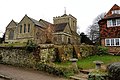
 Bletchingley, Church of St. Mary the Virgin - geograph.org.uk - 4201375.jpg 4,608 × 3,456; 6.49 MB
-
 Bletchingley, Church of St. Mary the Virgin - geograph.org.uk - 4201381.jpg 4,608 × 3,456; 6.59 MB
-
 Bletchingley, Church Walk - geograph.org.uk - 4343097.jpg 3,678 × 2,456; 5.08 MB
-
 Bletchingley, Church Walk - geograph.org.uk - 4343102.jpg 2,452 × 1,640; 2.5 MB
-
 Bletchingley, Church Walk - geograph.org.uk - 4344045.jpg 3,678 × 2,456; 4.37 MB
-
 Bletchingley, Church Walk - geograph.org.uk - 4344049.jpg 3,678 × 2,456; 4.5 MB
-

-
 Bletchingley, High Street - geograph.org.uk - 4201183.jpg 4,608 × 3,456; 5.96 MB
-
 Bletchingley, St Mary the Virgin - geograph.org.uk - 4342848.jpg 3,678 × 2,456; 4.21 MB
-
 Bletchingley, St Mary the Virgin - geograph.org.uk - 4343090.jpg 640 × 427; 71 KB
-
 Bletchingley, St Mary the Virgin - geograph.org.uk - 4343108.jpg 3,678 × 2,455; 5.46 MB
-
 Bletchingley, St Mary the Virgin - geograph.org.uk - 4343117.jpg 2,521 × 3,662; 3.91 MB
-
 Bletchingley, St Mary the Virgin - geograph.org.uk - 4343127.jpg 3,617 × 3,575; 6.52 MB
-
 Bletchingley, St Mary the Virgin - geograph.org.uk - 4343140.jpg 3,801 × 2,357; 5.33 MB
-
 Bletchingley, St Mary the Virgin - geograph.org.uk - 4343815.jpg 2,471 × 2,248; 2.89 MB
-
 Bletchingley, St Mary the Virgin - geograph.org.uk - 4343824.jpg 3,776 × 3,678; 6.43 MB
-
 Bletchingley, St Mary the Virgin - geograph.org.uk - 4343832.jpg 3,678 × 2,456; 4.16 MB
-
 Bletchingley, St Mary the Virgin - geograph.org.uk - 4343836.jpg 1,815 × 2,739; 2.6 MB
-
 Bletchingley, St Mary the Virgin - geograph.org.uk - 4343837.jpg 3,678 × 2,456; 4.65 MB
-
 Bletchingley, St Mary the Virgin - geograph.org.uk - 4343841.jpg 2,451 × 1,637; 2.73 MB
-
 Bletchingley, St Mary the Virgin - geograph.org.uk - 4343843.jpg 1,527 × 2,994; 2.84 MB
-
 Bletchingley, St Mary the Virgin - geograph.org.uk - 4343851.jpg 3,890 × 2,787; 4.54 MB
-
 Bletchingley, St Mary the Virgin - geograph.org.uk - 4343859.jpg 4,940 × 2,870; 7.61 MB
-
 Bletchingley, St Mary the Virgin - geograph.org.uk - 4343866.jpg 4,363 × 3,157; 6.97 MB
-
 Bletchingley, St Mary the Virgin - geograph.org.uk - 4343867.jpg 3,678 × 2,456; 4.26 MB
-
 Bletchingley, St Mary the Virgin - geograph.org.uk - 4343942.jpg 3,651 × 2,408; 4.12 MB
-
 Bletchingley, St Mary the Virgin - geograph.org.uk - 4343950.jpg 3,618 × 3,662; 7.5 MB
-
 Bletchingley, St Mary the Virgin - geograph.org.uk - 4343961.jpg 3,678 × 2,456; 3.08 MB
-
 Bletchingley, St Mary the Virgin - geograph.org.uk - 4343966.jpg 4,889 × 3,200; 5.76 MB
-
 Bletchingley, St Mary the Virgin - geograph.org.uk - 4343976.jpg 2,494 × 2,316; 3.04 MB
-
 Bletchingley, St Mary the Virgin - geograph.org.uk - 4343985.jpg 3,298 × 2,921; 7.71 MB
-
 Bletchingley, St Mary the Virgin - geograph.org.uk - 4343991.jpg 3,841 × 2,495; 6.48 MB
-
 Bletchingley, St Mary the Virgin - geograph.org.uk - 4343992.jpg 3,678 × 2,456; 4.44 MB
-
 Bletchingley, St Mary the Virgin - geograph.org.uk - 4344004.jpg 3,873 × 2,809; 6.79 MB
-
 Bletchingley, St Mary the Virgin - geograph.org.uk - 4344008.jpg 3,678 × 2,456; 3.89 MB
-
 Bletchingley, St Mary the Virgin - geograph.org.uk - 4344013.jpg 3,679 × 2,456; 7.28 MB
-
 Bletchingley, St Mary the Virgin - geograph.org.uk - 4344019.jpg 3,651 × 2,456; 3.68 MB
-
 Bletchingley, St Mary the Virgin - geograph.org.uk - 4344023.jpg 3,678 × 2,456; 5.49 MB
-
 Bletchingley, St Mary the Virgin - geograph.org.uk - 4344036.jpg 3,679 × 2,456; 7.23 MB
-
 Bletchingley, St Mary the Virgin - geograph.org.uk - 4344060.jpg 3,678 × 2,456; 5.54 MB
-
 Bletchingley, The 'Plough' - geograph.org.uk - 4201174.jpg 4,608 × 3,456; 6.37 MB
-
 Bletchingley, The 'Plough' - geograph.org.uk - 4201180.jpg 4,608 × 3,456; 6.2 MB
-
 Bletchingley, The 'Plough' - geograph.org.uk - 4201407.jpg 4,608 × 3,456; 6.46 MB
-
 Bletchingley, The 'William IV' - geograph.org.uk - 4201413.jpg 4,608 × 3,456; 6.15 MB
-
 Bletchingley, Timber-framed house - geograph.org.uk - 4201388.jpg 4,608 × 3,456; 6.35 MB
-
 Brewer Street - geograph.org.uk - 2245875.jpg 640 × 426; 116 KB
-

-
 Brick Kiln house,Bletchingley.jpg 5,184 × 3,456; 9.24 MB
-
 Bridge over the M25, east of junction 7 - geograph.org.uk - 2033705.jpg 640 × 430; 112 KB
-
 Bridge over the railway on Outwood Lane - geograph.org.uk - 4185833.jpg 2,560 × 1,920; 1.98 MB
-
 Bridging the Gap - geograph.org.uk - 2366104.jpg 2,560 × 1,920; 1.35 MB
-
 Bridleway - geograph.org.uk - 2968671.jpg 1,600 × 1,200; 421 KB
-
 Bridleway 228 - geograph.org.uk - 2968674.jpg 1,600 × 1,200; 306 KB
-
 Bridleway junction near Gravelly Hill - geograph.org.uk - 2950003.jpg 4,288 × 3,216; 7.14 MB
-
 Bridleway junction on White Hill - geograph.org.uk - 2950283.jpg 4,288 × 3,216; 4.81 MB
-
 Bridleway through Tye Copse - geograph.org.uk - 3187326.jpg 1,024 × 768; 683 KB
-
 Bridleway to Godstone (2) - geograph.org.uk - 2955476.jpg 4,288 × 3,216; 5.07 MB
-
 Bridleway to Godstone - geograph.org.uk - 2955467.jpg 4,288 × 3,216; 4.16 MB
-
 Bridleway to Godstone - geograph.org.uk - 2955482.jpg 4,288 × 3,216; 5.14 MB
-
 Bridleway to Green Lane - geograph.org.uk - 2955460.jpg 4,288 × 3,216; 5.42 MB
-
 Bridleway to Spring Bottom Lane - geograph.org.uk - 2952219.jpg 4,288 × 3,216; 6.81 MB
-
 Bus stop on the A25 Bletchingley - geograph.org.uk - 2340478.jpg 1,600 × 1,200; 552 KB
-
 Carlton Road, South Godstone - geograph.org.uk - 5254164.jpg 2,304 × 1,728; 865 KB
-
 Carlton Road, South Godstone - geograph.org.uk - 5254364.jpg 2,304 × 1,728; 858 KB
-
 Carlton Road, South Godstone - geograph.org.uk - 5254367.jpg 2,304 × 1,728; 863 KB
-
 Castle Cottages and Mead Cottage - geograph.org.uk - 1564682.jpg 640 × 426; 116 KB
-
 Caterham Viewpoint - geograph.org.uk - 2273749.jpg 640 × 426; 106 KB
-
 Chevington Villas on the A25 Bletchingley - geograph.org.uk - 2340547.jpg 1,600 × 1,200; 591 KB
-
 Church Lane - geograph.org.uk - 1956367.jpg 679 × 1,024; 196 KB
-

-

-
 Church Street, Bletchingley - geograph.org.uk - 98163.jpg 640 × 498; 131 KB
-
 Church Walk - geograph.org.uk - 2746294.jpg 425 × 640; 112 KB
-
 Church Walk, Bletchingley - geograph.org.uk - 2936402.jpg 2,520 × 1,680; 461 KB
-
 Cider House Gallery - geograph.org.uk - 1944617.jpg 2,642 × 3,786; 4.83 MB
-

-
 Clockwise M25 between J6 and J7 - geograph.org.uk - 3731965.jpg 640 × 480; 259 KB
-

-
 Club House, Bletchingley Golf Course - geograph.org.uk - 3075975.jpg 640 × 480; 73 KB
-
 Coppice Lea - geograph.org.uk - 5608391.jpg 1,280 × 851; 502 KB
-
 Cox's Bounty - geograph.org.uk - 2745494.jpg 640 × 425; 121 KB
-
 Cycling up Green Lane - geograph.org.uk - 2382962.jpg 1,024 × 768; 603 KB
-
 Daybreak - geograph.org.uk - 1956359.jpg 701 × 1,024; 244 KB
-
 Disused sand quarry, below Tilburstow Hill - geograph.org.uk - 2621444.jpg 1,600 × 1,064; 645 KB
-
 Divers Cove - geograph.org.uk - 4982257.jpg 4,288 × 2,864; 3.25 MB
-
 Diverted bridleway 142 - geograph.org.uk - 2240540.jpg 640 × 480; 187 KB
-
 Diverted bridleway 148 - geograph.org.uk - 2240531.jpg 640 × 480; 123 KB
-
 Double gate into a field - geograph.org.uk - 3187321.jpg 1,024 × 768; 432 KB
-
 Duck windmill, Lower Pendell Farm - geograph.org.uk - 2953138.jpg 4,288 × 3,216; 5.32 MB
-
 Eastward view along A25, Bletchingley (June 2013).JPG 2,500 × 1,500; 761 KB
-
 Eden Brook - geograph.org.uk - 1976890.jpg 640 × 426; 112 KB
-

-
 Entrance to Bletchingley Golf Club - geograph.org.uk - 4201369.jpg 4,608 × 3,456; 6.15 MB
-
 Entrance to Brewer Street Farm House - geograph.org.uk - 2245865.jpg 640 × 426; 97 KB
-
 Entrance to Garston Park - geograph.org.uk - 2265076.jpg 640 × 426; 93 KB
-
 Estate agents boards on Nightingale Way - geograph.org.uk - 3185691.jpg 1,024 × 768; 208 KB
-
 Estate houses at South Park (1) - geograph.org.uk - 3187297.jpg 1,024 × 768; 384 KB
-
 Estate houses at South Park (2) - geograph.org.uk - 3187300.jpg 1,024 × 768; 200 KB
-
 Farm on Carlton Road, South Godstone - geograph.org.uk - 5254368.jpg 2,304 × 1,728; 1.19 MB
-
 Farm track off Raby's Heath Road - geograph.org.uk - 3127046.jpg 1,024 × 768; 225 KB
-
 Farmland by the M25 - geograph.org.uk - 4569204.jpg 640 × 426; 62 KB
-
 Farmland, not far from Chaldon - geograph.org.uk - 48354.jpg 640 × 480; 77 KB
-
 Field by Carlton Road, South Godstone - geograph.org.uk - 5254157.jpg 2,304 × 1,728; 850 KB
-
 Field edge - geograph.org.uk - 3303519.jpg 640 × 425; 375 KB
-
 Field edge - geograph.org.uk - 3303556.jpg 640 × 425; 419 KB
-
 Field edge - geograph.org.uk - 3303583.jpg 640 × 425; 402 KB
-
 Field edge - geograph.org.uk - 3303594.jpg 640 × 425; 468 KB
-
 Field edge - geograph.org.uk - 3303613.jpg 640 × 425; 330 KB
-
 Field of daisies - geograph.org.uk - 1976934.jpg 640 × 426; 119 KB
-
 Fields and wood below Gravelly Hill - geograph.org.uk - 6074143.jpg 3,882 × 1,961; 1.21 MB
-
 Footbridge and gantry crossing the M25 - geograph.org.uk - 2033761.jpg 640 × 430; 115 KB
-
 Footbridge near Water Lane - geograph.org.uk - 2955424.jpg 4,288 × 3,216; 7.61 MB
-
 Footbridge, M25 near Godstone - geograph.org.uk - 2428108.jpg 640 × 324; 30 KB
-
 Footpath 289 - geograph.org.uk - 2968707.jpg 1,600 × 1,200; 341 KB
-
 Footpath approaching North Park Farm - geograph.org.uk - 2086364.jpg 640 × 480; 63 KB
-
 Footpath junction on Water Lane - geograph.org.uk - 2955437.jpg 4,288 × 3,216; 4.31 MB
-
 Footpath junction on Water Lane - geograph.org.uk - 2955445.jpg 4,288 × 3,216; 6.5 MB
-
 Footpath near Raby's Heath House. - geograph.org.uk - 4201165.jpg 4,608 × 3,456; 5.99 MB
-
 Footpath to Becks Cottage, Whitehill Lane - geograph.org.uk - 2955431.jpg 4,288 × 3,216; 4.51 MB
-
 Footpath to Bletchingley - geograph.org.uk - 2955463.jpg 4,288 × 2,966; 6.98 MB
-
 Footpath to Clare Cottages - geograph.org.uk - 2240406.jpg 640 × 480; 148 KB
-
 Footpath to Godstone - geograph.org.uk - 2955504.jpg 4,288 × 3,216; 7.06 MB
-
 Footpath towards Yew Tree Cottage - geograph.org.uk - 2953059.jpg 4,288 × 3,216; 6.68 MB
-
 Former bridleway junction near a sandy quarry - geograph.org.uk - 2955498.jpg 4,288 × 3,216; 5.42 MB
-
 Forsterdown Wood - geograph.org.uk - 4569211.jpg 640 × 426; 60 KB
-

-
 Frost on bridge over M23 - geograph.org.uk - 4278370.jpg 640 × 427; 80 KB
-
 Gallops - geograph.org.uk - 1931487.jpg 640 × 426; 105 KB
-
 Gantry, M25 - geograph.org.uk - 4510080.jpg 640 × 426; 51 KB
-
 Gantry, M25 - geograph.org.uk - 4510085.jpg 640 × 435; 57 KB
-
 Garage by track in Blindley Heath - geograph.org.uk - 5254478.jpg 2,304 × 1,728; 848 KB
-
 Gate on Bridleway - geograph.org.uk - 2968680.jpg 1,600 × 1,200; 356 KB
-
 Glenfield House - geograph.org.uk - 3354079.jpg 640 × 425; 266 KB
-
 Godstone Road - geograph.org.uk - 1957536.jpg 640 × 426; 123 KB
-
 Golf club crossing on Church Lane, Bletchingley - geograph.org.uk - 4186090.jpg 2,560 × 1,920; 2.07 MB
-
 Grange Meadow Sports Ground - geograph.org.uk - 3353083.jpg 640 × 425; 271 KB
-
 Green Lane passes under the M25 - geograph.org.uk - 2240522.jpg 640 × 480; 104 KB
-
 Greensand Way - geograph.org.uk - 2618815.jpg 1,600 × 1,064; 374 KB
-
 Greensand Way - geograph.org.uk - 2618819.jpg 1,600 × 1,064; 503 KB
-
 Greensand Way meets Coldharbour Lane - geograph.org.uk - 2621443.jpg 1,600 × 1,064; 669 KB
-
 Hanging Basket - geograph.org.uk - 1942079.jpg 681 × 1,024; 299 KB
-
 Heading to Godstone - geograph.org.uk - 1956330.jpg 1,024 × 681; 184 KB
-
 Hextalls Lane - geograph.org.uk - 2240467.jpg 640 × 480; 182 KB
-
 High Street - geograph.org.uk - 2746986.jpg 640 × 425; 74 KB
-
 High Street - geograph.org.uk - 3354063.jpg 640 × 425; 272 KB
-
 High Street - geograph.org.uk - 3354109.jpg 640 × 425; 269 KB
-
 High Street Bletchingley - geograph.org.uk - 2340881.jpg 1,600 × 1,200; 560 KB
-
 High Street Bletchingley - geograph.org.uk - 2340892.jpg 1,600 × 1,200; 565 KB
-
 High Street, Bletchingley - geograph.org.uk - 2315208.jpg 4,320 × 3,240; 4.15 MB
-
 High Street, Bletchingley - geograph.org.uk - 2315214.jpg 4,320 × 3,240; 4.22 MB
-
 High Street, Bletchingley, Surrey - geograph.org.uk - 2526304.jpg 2,767 × 1,841; 2.78 MB
-
 Hill House, Bletchingley, Surrey - geograph 7219372.jpg 1,024 × 684; 322 KB


_-_geograph.org.uk_-_2955476.jpg)


.JPG)


_-_geograph.org.uk_-_3187297.jpg)
_-_geograph.org.uk_-_3187300.jpg)


