Category:Bird's eye view maps of Seattle
Jump to navigation
Jump to search
Subcategories
This category has the following 2 subcategories, out of 2 total.
Media in category "Bird's eye view maps of Seattle"
The following 16 files are in this category, out of 16 total.
-
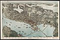
 Bird's Eye Map of Seattle 1889 (5276164889).jpg 7,294 × 4,594; 13.6 MB
-
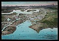
 Bird's Eye View, City of Seattle and vicinity, 1904 (MAPS 63).jpg 8,397 × 5,292; 15.4 MB
-

-
 Bird's-eye view of Seattle, 1908 (MOHAI 1390).jpg 640 × 454; 72 KB
-
 Bird's-eye View of Seattle, Washington Territory.jpg 873 × 639; 156 KB
-
-
 Birds Eye View of Seattle, 1889 (MOHAI 13218).jpg 1,000 × 642; 134 KB
-
-
 Birdseye view of Seattle 1908.jpg 2,817 × 1,788; 1.74 MB
-

-
 Seattle map, 1884 (SEATTLE 1600).jpg 761 × 512; 51 KB
-
 Seattle map, 1889 (SEATTLE 150).jpg 768 × 554; 139 KB
-
 Seattle map, 1891 (SEATTLE 803).jpg 768 × 527; 112 KB
-
 Seattle map, 1904 (SEATTLE 1191).jpg 768 × 498; 125 KB
-

-
.jpg)
.jpg)
.jpg)
.jpg)

.jpg)
.jpg)


.jpg)
.jpg)
.jpg)
.jpg)
.jpg)
.jpeg)
.jpeg)