Category:Bildstock Dorfstraße 38, Garstadt
Jump to navigation
Jump to search
| Object location | | View all coordinates using: OpenStreetMap |
|---|
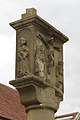
This is the category of the Bavarian Baudenkmal (cultural heritage monument) with the ID D-6-78-115-42 (Wikidata)
|
Deutsch: Bildstock, rechteckiger Tafelaufsatz mit Reliefdarstellung der Kreuzigung, auf Rundsäule über Sockel, Sandstein, bezeichnet 1625.
Vor Dorfstraße 38, Garstadt, Gemeinde Bergrheinfeld, Landkreis Schweinfurt, Unterfranken, Deutschland
Vor Dorfstraße 38, Garstadt, Gemeinde Bergrheinfeld, Landkreis Schweinfurt, Unterfranken, Deutschland
Media in category "Bildstock Dorfstraße 38, Garstadt"
The following 6 files are in this category, out of 6 total.
-
 Bildstock Dorfstraße 38, Garstadt 2014 1.jpg 2,368 × 3,420; 4.05 MB
-
 Bildstock Dorfstraße 38, Garstadt 2014 2.jpg 2,261 × 3,265; 3.12 MB
-
 Bildstock Dorfstraße 38, Garstadt 2014 3.jpg 2,032 × 3,038; 2.85 MB
-
 Gasthof Schiff Garstadt 2014 3.jpg 3,264 × 4,928; 6.31 MB
-
 Gasthof Schiff Garstadt 2014 4.jpg 3,264 × 4,928; 10.06 MB
-
 Gasthof Schiff Garstadt 2014 5.jpg 3,095 × 3,663; 6.67 MB


