Category:Biggin, North Yorkshire
Jump to navigation
Jump to search
village and civil parish in the Selby district of North Yorkshire, England  | |||||
| Upload media | |||||
| Instance of | |||||
|---|---|---|---|---|---|
| Location | Selby, North Yorkshire, Yorkshire and the Humber, England | ||||
 | |||||
English: Biggin is a village and civil parish in the Selby district of North Yorkshire, England, north-west of Selby. According to the 2001 census it had a population of 118.
Media in category "Biggin, North Yorkshire"
The following 72 files are in this category, out of 72 total.
-

-
 A stile all on its own - geograph.org.uk - 702363.jpg 600 × 400; 103 KB
-
 Agricultural Access Lane - geograph.org.uk - 388744.jpg 640 × 480; 106 KB
-
-
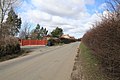
 Biggin - geograph.org.uk - 3585547.jpg 640 × 427; 94 KB
-
 Biggin age structure.png 350 × 270; 13 KB
-
 Biggin Crossroads - geograph.org.uk - 977735.jpg 640 × 475; 104 KB
-
 Biggin Lane - geograph.org.uk - 3585548.jpg 640 × 427; 102 KB
-
 Biggin Lane from Oxmoor Lane, Biggin - geograph.org.uk - 2153740.jpg 800 × 600; 301 KB
-
 Biggin Lane heading east - geograph.org.uk - 2414574.jpg 1,600 × 1,200; 577 KB
-
 Biggin Lane junction, Biggin - geograph.org.uk - 1759860.jpg 1,024 × 683; 158 KB
-
 Biggin Lane, heading east towards Biggin - geograph.org.uk - 4810493.jpg 1,024 × 768; 172 KB
-
 Biggin Lane, heading west - geograph.org.uk - 4810511.jpg 1,024 × 768; 152 KB
-
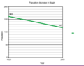 Biggin population decrease.PNG 349 × 274; 7 KB
-
 Bishop Dike, Sherburn in Elmet - geograph.org.uk - 606782.jpg 467 × 640; 57 KB
-
 Blocked field entrance, north side, Biggin Lane - geograph.org.uk - 4810494.jpg 1,024 × 614; 179 KB
-
 Bridge Farm near Biggin - geograph.org.uk - 2154336.jpg 800 × 600; 265 KB
-

-
 Croft farm, Biggin - geograph.org.uk - 1759738.jpg 1,024 × 683; 118 KB
-
 Croft Farm, Biggin - geograph.org.uk - 1759742.jpg 1,024 × 683; 124 KB
-
 Cyclist heading west out of Biggin - geograph.org.uk - 4810540.jpg 1,024 × 768; 145 KB
-
 Drain junction, south of Biggin Lane - geograph.org.uk - 4810517.jpg 1,024 × 768; 559 KB
-
 Drainage ditch, north side of Biggin Lane - geograph.org.uk - 4810534.jpg 1,024 × 768; 255 KB
-
 Emerging crop shadowed by hedgerow trees - geograph.org.uk - 4810509.jpg 1,024 × 614; 402 KB
-
 Emerging crop, north of Biggin Lane - geograph.org.uk - 4810506.jpg 1,024 × 768; 485 KB
-

-
 Farmland and woodland near Mattram Hall - geograph.org.uk - 2413870.jpg 1,600 × 1,200; 423 KB
-
 Farmland at Biggin Bridge - geograph.org.uk - 3585542.jpg 640 × 427; 114 KB
-
 Farmland near Biggin - geograph.org.uk - 3585544.jpg 640 × 427; 103 KB
-
 Farmland, Grange Farm - geograph.org.uk - 5305036.jpg 640 × 346; 29 KB
-
 Field entrance, south side of Biggin Lane - geograph.org.uk - 4810537.jpg 1,024 × 768; 194 KB
-
 Fields to Fir Tree Farm, Biggin - geograph.org.uk - 2022273.jpg 640 × 480; 39 KB
-
 Fir Tree Farm - geograph.org.uk - 4252305.jpg 640 × 436; 33 KB
-
 Footpath leading to Grange farm - geograph.org.uk - 1885045.jpg 800 × 533; 125 KB
-
 Footpath near Biggin - geograph.org.uk - 3585552.jpg 640 × 427; 85 KB
-
 Gale House Farm - geograph.org.uk - 2342670.jpg 640 × 430; 28 KB
-
 Gated farm track, Biggin - geograph.org.uk - 2414577.jpg 1,600 × 1,200; 654 KB
-

-

-
 Landscape with trees, near Spring Well House - geograph.org.uk - 4810526.jpg 1,024 × 768; 488 KB
-
 Little Lane (formerly Town Street), Biggin - geograph.org.uk - 1759759.jpg 1,024 × 683; 196 KB
-
 Little Lane (formerly Town Street), Biggin - geograph.org.uk - 1759787.jpg 1,024 × 683; 184 KB
-
 Little Lane, Biggin - geograph.org.uk - 2154320.jpg 800 × 600; 350 KB
-

-
 Low Rest Park Farm - geograph.org.uk - 281832.jpg 640 × 480; 56 KB
-
 Low Rest Park Farm Sign - geograph.org.uk - 702368.jpg 600 × 400; 111 KB
-
 Mattram Barn, Biggin - geograph.org.uk - 606784.jpg 640 × 458; 80 KB
-
 Mattram Hall - geograph.org.uk - 2413859.jpg 1,600 × 1,200; 515 KB
-

-
 Mattram Hall near Biggin - geograph.org.uk - 2363676.jpg 800 × 600; 200 KB
-
 Mattram Hall, Biggin.jpg 480 × 640; 89 KB
-
 Partridge Hill Farm - geograph.org.uk - 197612.jpg 640 × 458; 141 KB
-
 Private Road - geograph.org.uk - 956937.jpg 640 × 480; 59 KB
-
 Southern approach Road to Biggin - geograph.org.uk - 1759747.jpg 1,024 × 683; 150 KB
-
 Sycamore Farm buildings, Biggin - geograph.org.uk - 1759871.jpg 1,600 × 1,067; 300 KB
-
 Sycamore Farm, Biggin - geograph.org.uk - 1759866.jpg 1,600 × 1,067; 293 KB
-
 Sycamore Farm, Biggin - geograph.org.uk - 1759887.jpg 1,600 × 1,067; 375 KB
-
 The Blacksmith Arms, Biggin.jpg 500 × 680; 79 KB
-
 The Blacksmith's Arms, Biggin - geograph.org.uk - 2153734.jpg 800 × 600; 259 KB
-
 The Kingfisher Pub, Biggin - geograph.org.uk - 293502.jpg 640 × 480; 74 KB
-
 The Old School, Biggin - geograph.org.uk - 1759771.jpg 1,024 × 683; 208 KB
-

-

-
 Trees and tree shadows, off Biggin Lane - geograph.org.uk - 4810530.jpg 1,024 × 768; 143 KB
-
 Typical House on Little Lane, Biggin - geograph.org.uk - 1759777.jpg 1,024 × 683; 206 KB
-
 Typical houses in Biggin Village - geograph.org.uk - 1759845.jpg 1,600 × 1,067; 394 KB
-
 View of Village Post Box and Old School House, Biggin - geograph.org.uk - 1759824.jpg 1,600 × 1,067; 389 KB
-
 View towards Oxmoor Lane, Biggin - geograph.org.uk - 1759811.jpg 1,600 × 1,067; 301 KB
-
 Village Post Box and view of new infill housing, Biggin - geograph.org.uk - 1759814.jpg 1,600 × 1,067; 332 KB
-
 Water-filled drain, south side of Biggin Lane - geograph.org.uk - 4810522.jpg 768 × 1,024; 504 KB
-
 West of Biggin - geograph.org.uk - 606763.jpg 453 × 640; 82 KB
-
 Woodcock Drain - geograph.org.uk - 2414569.jpg 1,600 × 1,200; 534 KB


_Biggin_-_geograph.org.uk_-_1759805.jpg)


,_Biggin_-_geograph.org.uk_-_1759759.jpg)
,_Biggin_-_geograph.org.uk_-_1759787.jpg)


