Category:Bethel Ziekenhuis (Delft)
Jump to navigation
Jump to search
| Object location | | View all coordinates using: OpenStreetMap |
|---|
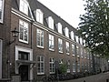
building in Delft, Netherlands  | |||||
| Upload media | |||||
| Instance of | |||||
|---|---|---|---|---|---|
| Location | Delft, South Holland, Netherlands | ||||
| Located on street | |||||
| Heritage designation |
| ||||
 | |||||
Nederlands: Bethel Ziekenhuis, Delft
|
This is a category about rijksmonument number 12039
|
| Address |
|
Media in category "Bethel Ziekenhuis (Delft)"
The following 11 files are in this category, out of 11 total.
-
 Bethel Ziekenhuis - Delft - Brinio BR - 03072 - 20595363 - RCE.jpg 1,200 × 854; 351 KB
-
 Bethel Ziekenhuis hal - Delft - Brinio BR - 03071 - 20595362 - RCE.jpg 1,200 × 854; 234 KB
-
 Delft - Bagijnhof 31.jpg 2,592 × 1,944; 1.47 MB
-
 Interieur schouw (empire) - Delft - 20052826 - RCE.jpg 1,188 × 1,200; 227 KB
-

-
 Ziekenhuis "Bethel" - Delft - 20052322 - RCE.jpg 1,200 × 1,195; 387 KB
-
 Ziekenhuis "Bethel" - Delft - 20052323 - RCE.jpg 1,190 × 1,200; 350 KB
-
 Ziekenhuis "Bethel" - Delft - 20052324 - RCE.jpg 1,200 × 1,185; 365 KB
-
 Ziekenhuis "Bethel" - Delft - 20052326 - RCE.jpg 1,197 × 1,200; 384 KB
-
 Ziekenhuis "Bethel" - Delft - 20052327 - RCE.jpg 1,200 × 1,195; 284 KB
-
 Ziekenhuis Bethel te Delft - Delft - 20052325 - RCE.jpg 1,200 × 1,188; 270 KB


_-_Delft_-_20052826_-_RCE.jpg)


