Category:Berninapass
Jump to navigation
Jump to search
| Object location | | View all coordinates using: OpenStreetMap |
|---|
mountain pass  | |||||
| Upload media | |||||
| Instance of |
| ||||
|---|---|---|---|---|---|
| Location | Grisons, Switzerland | ||||
| Mountain range | |||||
| Elevation above sea level |
| ||||
 | |||||
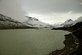
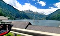
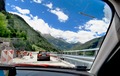
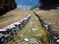
Deutsch: Der Berninapass (ital. Passo del Bernina) ist ein Alpenpass im Schweizer Kanton Graubünden.
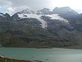
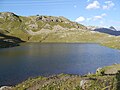
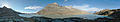
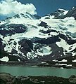
English: The Bernina Pass (el. 2328 m.) (Italian: Passo del Bernina) is a high mountain pass in the Bernina Range of the Alps, in the canton of Graubünden in Switzerland.
Subcategories
This category has the following 8 subcategories, out of 8 total.
C
- Cambrena Glacier (62 F)
L
- La Rösa (9 F)
- Lagh da la Cruseta (11 F)
- Lej Nair (Bernina) (33 F)
O
S
- Sfazù (1 F)
- Sperrstelle Berninahäuser (9 F)
Media in category "Berninapass"
The following 184 files are in this category, out of 184 total.
-
 Karte Berninapass.png 1,181 × 768; 387 KB
-
 1997-Piz-Palue.jpg 600 × 402; 49 KB
-
 Profil Berninapass.png 1,053 × 656; 56 KB
-
 Berninapass-002.jpg 3,264 × 2,448; 6.9 MB
-
 2007 10 Berninabahn 040780.jpg 2,811 × 2,112; 2.91 MB
-
 2007 10 Berninabahn 040790.jpg 2,814 × 2,114; 3.08 MB
-
 2007 10 Berninabahn 040820.jpg 2,664 × 2,001; 2.27 MB
-
 2007 10 Berninabahn 040870.jpg 2,800 × 2,104; 3.29 MB
-
 2007 10 Berninabahn 040880.jpg 2,811 × 2,112; 2.93 MB
-
 2007 10 Berninabahn 040920.jpg 2,763 × 2,076; 3.06 MB
-
 2007 10 Berninabahn 040940.jpg 2,664 × 2,001; 2.47 MB
-
 2007 10 Berninabahn 041000.jpg 2,775 × 2,085; 2.75 MB
-
 2007 10 Berninabahn 041020.jpg 2,751 × 2,067; 2.46 MB
-
 2007 10 Berninabahn 041030.jpg 2,808 × 2,110; 3.2 MB
-
 2007 10 Berninabahn 041040.jpg 2,811 × 2,112; 2.3 MB
-
 2007 10 Berninabahn 041100.jpg 2,664 × 2,001; 1.93 MB
-
 2007 10 Berninabahn 041110.jpg 2,664 × 2,001; 1.77 MB
-
 2007 10 Berninabahn 041180.jpg 2,814 × 2,114; 3.05 MB
-
 2007 10 Berninabahn 041200.jpg 2,796 × 2,100; 2.8 MB
-
 2007 10 Berninabahn 041210.jpg 2,784 × 2,091; 2.73 MB
-
 2007 10 Berninabahn 041230.jpg 2,760 × 2,073; 2.79 MB
-
 2007 10 Berninabahn 041330.jpg 2,814 × 2,114; 3.31 MB
-
 2007 10 Berninabahn 041340.jpg 2,808 × 2,110; 2.72 MB
-
 2007 10 Berninabahn 041350.jpg 2,812 × 2,112; 3.07 MB
-
 2007 10 Berninabahn 041370.jpg 2,796 × 2,100; 3.27 MB
-
 2007 10 Berninabahn 041530.jpg 2,667 × 2,004; 2.94 MB
-
 2007 10 Berninabahn 041540.jpg 2,822 × 2,120; 2.4 MB
-
 2007 10 Berninabahn 041560.jpg 2,820 × 2,118; 3.21 MB
-
 2007 10 Berninabahn 041610.jpg 2,816 × 2,116; 4.13 MB
-
 2007 10 Berninabahn 041620.jpg 2,816 × 2,116; 3.29 MB
-
 2007 10 Berninabahn 041640.jpg 2,816 × 2,116; 4.31 MB
-
 2007 10 Berninabahn 041650.jpg 2,814 × 2,114; 3.62 MB
-
 2007 10 Berninabahn 041660.jpg 2,818 × 2,118; 3.65 MB
-
 2007 10 Berninabahn 041680.jpg 2,812 × 2,112; 3.98 MB
-
 2007 10 Berninabahn 041700.jpg 2,805 × 2,106; 2.78 MB
-
 2007 10 Berninabahn 041730.jpg 2,727 × 2,049; 2.3 MB
-
 2007 10 Berninabahn 041740.jpg 2,799 × 2,103; 2.35 MB
-
 Bernina - panoramio (3).jpg 2,896 × 1,944; 1.51 MB
-
 BERNINA 2xP1000703.tif 4,320 × 2,880; 35.62 MB
-
 BERNINA 4xyP1000700.jpg 4,316 × 2,692; 11.1 MB
-
 BERNINA 5xP1000692.tif 4,308 × 2,580; 31.82 MB
-
 BERNINA 5xP1000693.tif 4,308 × 2,596; 32.02 MB
-
 BERNINA 5xP1000694.tif 4,060 × 2,556; 29.71 MB
-
 Bernina Hospiz.jpg 2,592 × 1,944; 1.41 MB
-
 Bernina Pass (& Lago Bianco).JPG 2,048 × 1,536; 2.02 MB
-
 Bernina Pass-ascent from Italian side LCCN94514212.jpg 4,096 × 3,281; 1.98 MB
-
 Bernina Pass-ascent from Italian side LCCN94514212.tif 4,096 × 3,281; 12.82 MB
-
 Bernina Pass. Cambrina Glacier LCCN94514214.jpg 4,096 × 3,290; 1.59 MB
-
 Bernina Pass. Cambrina Glacier LCCN94514214.tif 4,096 × 3,290; 12.85 MB
-
 Bernina Pass. Cambrina Glacier LCCN94514215.jpg 4,096 × 3,275; 2.04 MB
-
 Bernina Pass. Cambrina Glacier LCCN94514215.tif 4,096 × 3,275; 12.79 MB
-
 Bernina Passhöhe.jpg 3,894 × 2,237; 2.83 MB
-
 Bernina Saumpfad01.jpg 1,536 × 2,048; 1.53 MB
-
 Bernina Saumpfad02.jpg 2,048 × 1,536; 1.58 MB
-
 Bernina--glacier grind-01.jpg 4,592 × 2,576; 4.25 MB
-
 Bernina-Berninabahn power pole-01E.jpg 3,024 × 4,032; 5.61 MB
-
 Bernina-Berninabahn power pole-erica-01E.jpg 3,024 × 4,032; 5.27 MB
-
 Bernina-Berninabahn-glacier grind-01E.jpg 4,032 × 3,024; 5.08 MB
-
 Bernina-Berninabahn-Lago Bianco-view from the dam south-01.jpg 4,592 × 2,576; 3.75 MB
-
 Bernina-Berninabahn-Lago Bianco-view to south-01.jpg 4,592 × 2,576; 3.09 MB
-
 Bernina-Berninabahn-Lago Bianco-view to south-03.jpg 4,592 × 2,576; 4.25 MB
-
 Bernina-Berninabahn-Lago Bianco-view to the dam south-glacier grind-01.jpg 4,592 × 2,576; 3.84 MB
-
 Bernina-Berninabahn-Lago Bianco-view to west-02.jpg 4,592 × 2,576; 3.41 MB
-
 Bernina-Berninabahn-signpost-01.jpg 2,576 × 4,592; 5.41 MB
-
 Bernina-hágó.jpg 4,320 × 2,880; 4.9 MB
-
 Bernina-Lago Bianco-view to north-05.jpg 4,592 × 2,576; 2.84 MB
-
 Bernina-Lago Bianco-view to north-signpost-01.jpg 4,592 × 2,576; 3.5 MB
-
 Bernina-Lago Bianco-view to south-04.jpg 4,592 × 2,576; 3.44 MB
-
 Bernina-Lago Bianco-view to south-05.jpg 4,592 × 2,576; 3.78 MB
-
 Berninabahn banner.jpg 2,100 × 300; 384 KB
-
 Berninabahn-engineering structures-gallery roof-02.jpg 4,592 × 2,576; 4.53 MB
-
 BerninaExpress.PNG 500 × 373; 378 KB
-
 Berninapass 1877 Siegfriedkarte.jpg 1,591 × 1,119; 1.45 MB
-
 Berninapass Lago Bianco2.jpg 4,500 × 3,000; 2.36 MB
-
 Berninapass-003.jpg 3,264 × 2,448; 4.61 MB
-
 Berninapass.jpg 437 × 296; 23 KB
-
 Berninapassautumn.jpg 4,000 × 3,000; 3.21 MB
-
 BerninapasshöheSee.jpg 4,000 × 3,000; 6.73 MB
-
 Berninapassstrasse und Lagh de la Cruseta 20081011.jpg 3,504 × 2,336; 6.95 MB
-
 Brutarchitekt Bearth Deplazes.jpg 2,969 × 2,658; 1.44 MB
-
 Cavaglia-Alp Grüm- Berninabahn-04.jpg 4,592 × 2,576; 4.19 MB
-
 CH bernina pass2.jpg 2,272 × 1,704; 1.17 MB
-
 CH-NB-200 Schweizer Bilder-nbdig-18634-page269.tif 1,204 × 1,665; 4.61 MB
-
 Corn da Mürasciola as seen from Passo del Bernina.jpg 4,032 × 3,024; 2.86 MB
-

-
 ETH-BIB-Bernina, Berninabahntracé, Häuser v. S. O.-Inlandflüge-LBS MH01-005073.tif 6,531 × 4,749; 88.89 MB
-
 ETH-BIB-Berninapass oberhalb Poschiavo-LBS H1-017981.tif 6,530 × 4,599; 86.09 MB
-
 ETH-BIB-Berninapass v. S.-Inlandflüge-LBS MH01-005083.tif 4,594 × 6,445; 84.87 MB
-
 ETH-BIB-Berninapass, Blick nach Nordwesten, Val Bernina-LBS H1-017960.tif 6,565 × 4,599; 86.54 MB
-
 ETH-BIB-Berninapass, Blick nach Nordwesten, Val Bernina-LBS H1-017961.tif 6,600 × 4,604; 87.1 MB
-
 ETH-BIB-Berninapass, Blick nach Südsüdosten, Val Poschiavo-LBS H1-017963.tif 6,546 × 4,591; 86.13 MB
-
-
 ETH-BIB-Berninapass, Piz Palü v. N. W. aus 3500 m-Inlandflüge-LBS MH01-000876.tif 6,794 × 4,579; 89.14 MB
-

-
 ETH-BIB-Berninapass, Val di Poschiavo, Puschlav v. N. W.-Inlandflüge-LBS MH01-005081.tif 6,397 × 4,592; 84.19 MB
-
 ETH-BIB-Berninapass, Val di Poschiavo, Puschlav v. N. W.-Inlandflüge-LBS MH01-005082.tif 6,561 × 4,590; 86.3 MB
-

-
 ETH-BIB-Berninapass-LBS H1-025735.tif 6,634 × 4,678; 88.83 MB
-
 ETH-BIB-Lago Bianco, Berninapass, Piz Palü-Inlandflüge-LBS MH05-50-24.tif 3,508 × 2,360; 23.74 MB
-
 ETH-BIB-Lago Bianco, Berninapass,-Inlandflüge-LBS MH05-50-23.tif 2,354 × 3,508; 23.68 MB
-

-
 ETH-BIB-Pontresina, Berninapass aus 3800 m-Inlandflüge-LBS MH01-000869.tif 6,822 × 4,616; 90.23 MB
-
 ETH-BIB-S. Carlo, Poschivao, Cavaglia, E. W. Robbia, Berninapass-Inlandflüge-LBS MH01-005086.tif 6,391 × 4,591; 84.11 MB
-
 ETH-BIB-Val Bernina, Blick nach Südosten Berninapass-LBS H1-011521.tif 6,704 × 4,655; 89.45 MB
-

-
 ETH-BIB-Val Laguné, Campasc, Blick nach Nordwesten, Munt Pers-LBS H1-017943.tif 6,573 × 4,587; 86.4 MB
-
 ETH-BIB-Val Laguné, Campasc, Blick nach Nordwesten, Munt Pers-LBS H1-017967.tif 6,577 × 4,590; 86.54 MB
-
 ETH-BIB-Val Poschiavo,, Blick nach Nordnordwesten, Berninapass-LBS H1-017968.tif 6,628 × 4,610; 87.58 MB
-
 Fanck arnold ernst + fritz aly cropped.png 924 × 839; 820 KB
-
 Fanck arnold ernst + fritz aly.png 2,259 × 1,503; 3.42 MB
-
 Forcola di Livigno.jpg 500 × 333; 66 KB
-
 Fotografi av Berninapass - Hallwylska museet - 104857.tif 4,246 × 3,449; 41.93 MB
-
 Graubünden Berninapass 01.JPG 3,444 × 2,586; 4.6 MB
-
 Graubünden Berninapass 02.JPG 3,444 × 2,586; 4.47 MB
-
 Graubünden Berninapass 03.JPG 3,444 × 2,586; 5.24 MB
-
 Graubünden Berninapass 04.JPG 3,444 × 2,586; 5.53 MB
-
 Graubünden Berninapass 05.JPG 3,444 × 2,586; 6.63 MB
-
 Graubünden Berninapass 06.JPG 3,444 × 2,586; 6.98 MB
-
 Graubünden Berninapass 07.JPG 3,444 × 2,586; 4.87 MB
-
 Graubünden Berninapass 08.JPG 3,444 × 2,586; 4.8 MB
-
 Graubünden Berninapass 09.JPG 3,444 × 2,586; 4.92 MB
-
 Graubünden Berninapass 10.JPG 3,444 × 2,586; 5.12 MB
-
 Graubünden Berninapass 11.JPG 3,444 × 2,586; 5.43 MB
-
 Graubünden Berninapass 12.JPG 3,444 × 2,586; 5.29 MB
-
 Graubünden Berninapass 13.JPG 3,444 × 2,586; 6.44 MB
-
 Graubünden Berninapass 14.JPG 3,444 × 2,586; 5.7 MB
-
 Graubünden Berninapass 15.JPG 3,444 × 2,586; 6.13 MB
-
 Graubünden Berninapass 16.JPG 3,444 × 2,586; 5.77 MB
-
 Graubünden Berninapass 17.JPG 3,444 × 2,586; 6.34 MB
-
 Graubünden Berninapass 18.JPG 3,444 × 2,586; 5.35 MB
-
 Graubünden Berninapass 19.JPG 3,444 × 2,586; 5.39 MB
-
 Graubünden Berninapass 20.JPG 3,444 × 2,586; 5.27 MB
-
 Graubünden Berninapass 21.JPG 3,444 × 2,586; 4.82 MB
-
 Graubünden Berninapasshöhe 1.JPG 3,444 × 2,586; 6.45 MB
-
 Graubünden Berninapasshöhe 2.JPG 3,444 × 2,586; 6.03 MB
-
 Graubünden Berninapasshöhe 3.JPG 3,444 × 2,586; 5.43 MB
-
 Graubünden Berninapasshöhe 4.JPG 3,444 × 2,586; 4.69 MB
-
 Graubünden Berninapasshöhe 5.JPG 3,444 × 2,586; 5.74 MB
-
 Graubünden Berninapasshöhe 6.JPG 3,444 × 2,586; 5.17 MB
-
 Graubünden Berninapasshöhe 7.JPG 3,444 × 2,586; 6.62 MB
-
 Graubünden Berninapasshöhe 8.JPG 3,444 × 2,586; 7.08 MB
-
 Graubünden Berninapasshöhe 9.JPG 3,444 × 2,586; 7.16 MB
-
 Helicopter over Bernina-01.jpg 4,592 × 2,576; 2.38 MB
-
 Hiking trail to Albergo Sassal Mason-01.jpg 4,592 × 2,576; 7.69 MB
-
 Hikingtrial Valposchiavo-Pozzo del Drago-RE Power-01.jpg 4,592 × 2,576; 5.31 MB
-
 Hikingtrial Valposchiavo-Pozzo del Drago-sign-03.jpg 4,592 × 2,576; 6.41 MB
-
 Hikingtrial Valposchiavo-Pozzo del Drago-signpost-01.jpg 2,576 × 4,592; 5.75 MB
-
 Hikingtrial Valposchiavo-Pozzo del Drago-signpost-02.jpg 2,576 × 4,592; 4.81 MB
-
 Hikingtrial Valposchiavo-Signpost-Via Valtelina-01.jpg 2,576 × 4,592; 6.06 MB
-
 Hikingtrial Valposchiavo-view to Albergo Sassal Mason-01.jpg 4,592 × 2,576; 4.09 MB
-
 KARTE Bernina1.png 271 × 249; 50 KB
-
 Kurz vor der Passhöhe Bernina - panoramio.jpg 4,000 × 3,000; 3.97 MB
-
 Lago Bianco Am Berninapass.jpg 800 × 593; 102 KB
-
 Lago Bianco Morgensonne.jpg 11,695 × 3,000; 8.98 MB
-
 Lago Bianco Piz Campasc.jpg 16,659 × 3,000; 12.42 MB
-
 Lago Bianco Piz Lagalb1.jpg 4,500 × 3,000; 3.83 MB
-
 Lago Bianco Sassal Mason.jpg 6,000 × 3,000; 6.43 MB
-
 Lago Bianco.jpg 2,048 × 1,445; 317 KB
-
 LhBerninaPass.jpg 1,622 × 1,798; 683 KB
-
 Li Mason auf 1947m an der Bernina Passstraße.JPG 5,732 × 3,018; 9.65 MB
-
 Nuvole Mutevoli.jpg 5,312 × 2,988; 5.4 MB
-
 Paesaggio incorniciato.jpg 5,312 × 2,988; 4.44 MB
-
 Palügletscher 2011.JPG 2,048 × 1,536; 1.79 MB
-
 Paolo Monti - Serie fotografica (Livigno, 1971) - BEIC 6332641.jpg 1,280 × 842; 1.07 MB
-
 Paolo Monti - Serie fotografica (Livigno, 1971) - BEIC 6332642.jpg 847 × 1,280; 1.05 MB
-
 Passo del Bernina - panoramio (1).jpg 1,600 × 1,200; 588 KB
-
 Passo del Bernina - panoramio.jpg 1,600 × 1,200; 592 KB
-
 Passo del Bernina 01.png 720 × 405; 586 KB
-
 Passo del Bernina 02.jpg 1,024 × 576; 806 KB
-
 Passo del Bernina 03.jpg 1,024 × 576; 676 KB
-
 Passo del Bernina 04.jpg 1,024 × 576; 711 KB
-
 Passo del Bernina.jpg 5,312 × 2,988; 6.45 MB
-
 Pizarlas.jpg 796 × 594; 119 KB
-
 Poschiavo, Switzerland - panoramio (10).jpg 5,780 × 2,834; 4.45 MB
-
 Poschiavo, Switzerland - panoramio (2).jpg 4,896 × 3,264; 1.8 MB
-
 Poschiavo, Switzerland - panoramio (3).jpg 4,896 × 3,264; 2.07 MB
-
 Poschiavo, Switzerland - panoramio (4).jpg 4,896 × 3,264; 2.19 MB
-
 Poschiavo, Switzerland - panoramio (6).jpg 4,896 × 3,264; 1.62 MB
-
 Poschiavo, Switzerland - panoramio (7).jpg 4,896 × 3,264; 1.8 MB
-
 Rosse e umane impressioni.jpg 5,312 × 2,988; 4.72 MB
-
 Sguardi curiosi.jpg 5,312 × 2,988; 6.57 MB
-
 Upper Engadine, Bernina Hospice and Cambrena Glacier, Grisons, Switzer-LCCN2001703002.jpg 3,674 × 2,728; 2.91 MB
-
 Val Poschiavo - panoramio (1).jpg 2,048 × 1,536; 1.16 MB
-
 Wilhelm Ludwig Lehmann Bernina-Passhöhe 1902.jpg 2,560 × 1,761; 2.34 MB


.jpg)


.JPG)


_-_BEIC_6332641.jpg)
_-_BEIC_6332642.jpg)
.jpg)


.jpg)
.jpg)
.jpg)
.jpg)
.jpg)
.jpg)


.jpg)
