Category:Batofar (ship, 1955)
Jump to navigation
Jump to search
| Object location | | View all coordinates using: OpenStreetMap |
|---|
English:
Ship
- Ordered: 01.1953
- Built by: Shipyard: Philip & Son Ltd., Dartmouth, Devon, England
- Yard-No.: 1269
- Contract price: 102,203 £, Profit 14,693 £
- Launched: 22.04.1955
- Date of completion: 21.06.1955
- Length o.a.: 134 feet (ca. 40.84 m)
- LPP: 119 feet (ca. 36.27 m)
- Beam: 25 feet (ca. 7.62 m)
- Draught: 15 feet (ca. 4.57 m)
- Displacement: 345 tons
History
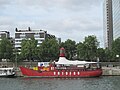
- 1955 Named: OSPREY for Commissioners of Irish Lights, Dublin
- 14.07.1974 Daunt Lightship
- 09.05.1975 Decommissioned, replaced by a flashing buoy and sold to New Ross Harbour Commission as a floating oil berth/pilot station
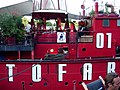
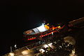
- 03.1998 Sold to French owners and towed to Paris Refit as a floating diskotheque in Paris Renamed: BATOFAR
Français : Le Batofar , sur un quai de Seine à Paris (Ancien bateau-phare)
theatre boat moored in Paris, France, originally an Irish lighthouse boat   | |||||
| Upload media | |||||
| Instance of | |||||
|---|---|---|---|---|---|
| Location | 13th arrondissement of Paris, Paris, Grand Paris | ||||
| Owned by |
| ||||
| Operator | |||||
| Manufacturer | |||||
| Shipping port | |||||
| Country of registry | |||||
| Service entry |
| ||||
| Beam |
| ||||
| Draft |
| ||||
| Length |
| ||||
| official website | |||||
 | |||||
Media in category "Batofar (ship, 1955)"
The following 15 files are in this category, out of 15 total.
-
 Batofar - Paris.JPG 2,272 × 1,704; 1,001 KB
-
 Batofar 01.jpg 2,592 × 1,944; 1.92 MB
-
 Batofar 02.jpg 3,072 × 2,304; 1.12 MB
-
 Batofar 03.jpg 681 × 1,024; 92 KB
-
 Batofar 04.jpg 500 × 375; 42 KB
-
 Batofar by night from above.jpg 4,912 × 3,264; 3.23 MB
-
 Batofar by night.jpg 4,912 × 3,264; 2.92 MB
-
 Batofar en travaux.jpg 1,536 × 2,048; 1.41 MB
-
 Batofar Paris Richard Bartz.jpg 2,000 × 1,333; 1.48 MB
-
 Batofar.jpg 4,416 × 3,312; 1.52 MB
-
 Le Batofar.jpg 3,648 × 2,736; 1.53 MB
-
 Paris 13th bat o far.jpg 480 × 640; 58 KB
-
 Paris Ministere des Finances vu de devant le Batofar p1040547.jpg 2,560 × 1,920; 2.04 MB
-
 Paris Ministere des Finances vu de devant le Batofar processed p1040547.jpg 1,280 × 960; 277 KB
-
 Rendez-vous aux jardins 2013, Paris.jpg 3,648 × 2,736; 2.17 MB


