Category:Barrier Gardens Pier
Jump to navigation
Jump to search
| Object location | | View all coordinates using: OpenStreetMap |
|---|
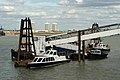
English: Barrier Gardens Pier is a pier on the River Thames near the Thames Barrier. The PLA uses the pier as a base for their Driftwood craft and upper river harbour patrol vessels. The pier is also used by external companies to moor at and embark/disembark passengers to the Thames Barrier Visitor Centre.
Pier on the River Thames near the Thames Barrier  | |||||
| Upload media | |||||
| Instance of | |||||
|---|---|---|---|---|---|
| Location | London, Greater London, London, England | ||||
| Located in or next to body of water | |||||
| Owned by | |||||
 | |||||
Media in category "Barrier Gardens Pier"
The following 3 files are in this category, out of 3 total.
-
 Barrier Gardens pier at high tide - geograph.org.uk - 3833758.jpg 640 × 480; 92 KB
-
 Barrier Gardens Pier in London.jpg 3,078 × 1,542; 393 KB
-