Category:Baksteenfabriek Bunswaard, Beuningen
Jump to navigation
Jump to search
| Object location | | View all coordinates using: OpenStreetMap |
|---|
 | |||||
| Upload media | |||||
| Instance of | |||||
|---|---|---|---|---|---|
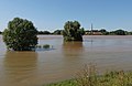
| Location | Beuningen, Gelderland, Netherlands | ||||
| Has part(s) | |||||
| Heritage designation |
| ||||
| Inception |
| ||||
 | |||||
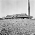
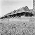
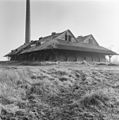
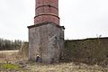
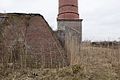
Schoorsteen en steenoven:
|
This is a category about rijksmonument number 523166
|
Veldoven:
|
This is a category about rijksmonument number 523167
|
| Address |
|
Media in category "Baksteenfabriek Bunswaard, Beuningen"
The following 22 files are in this category, out of 22 total.
-
 Beuningen Rijksmonument 523166 steenfabriek de Bunswaard toegangsweg.JPG 3,648 × 2,736; 4.21 MB
-
 Beuningen, Rijksmonument 523166 De Bunswaard.JPG 3,648 × 2,736; 3.56 MB
-
-
 Exterieur OVERZICHT - Beuningen - 20270786 - RCE.jpg 1,200 × 1,200; 353 KB
-
 Exterieur OVERZICHT - Beuningen - 20270787 - RCE.jpg 1,191 × 1,200; 366 KB
-
 Exterieur OVERZICHT - Beuningen - 20270788 - RCE.jpg 1,200 × 1,200; 415 KB
-
 Exterieur OVERZICHT - Beuningen - 20270789 - RCE.jpg 1,188 × 1,200; 334 KB
-
 Exterieur OVERZICHT - Beuningen - 20270790 - RCE.jpg 1,193 × 1,200; 369 KB
-
 Exterieur OVERZICHT - Beuningen - 20270791 - RCE.jpg 1,193 × 1,200; 351 KB
-
 Exterieur OVERZICHT - Beuningen - 20270792 - RCE.jpg 1,195 × 1,200; 378 KB
-
 Exterieur OVERZICHT - Beuningen - 20270793 - RCE.jpg 1,193 × 1,200; 398 KB
-
 Noordgevel - Beuningen - 20533830 - RCE.jpg 800 × 1,200; 217 KB
-
 Noordgevel midden deels ingestort - Beuningen - 20533829 - RCE.jpg 800 × 1,200; 248 KB
-
 Overzicht uit het oosten - Beuningen - 20533825 - RCE.jpg 1,200 × 1,200; 318 KB
-
 Overzicht van schoorsteen - Beuningen - 20533823 - RCE.jpg 800 × 1,200; 147 KB
-
 Overzicht van schoorsteen - Beuningen - 20533824 - RCE.jpg 800 × 1,200; 152 KB
-
 Overzicht westgevel - Beuningen - 20533831 - RCE.jpg 1,200 × 800; 137 KB
-
 Overzicht zuidgevel van steenfabriek - Beuningen - 20533827 - RCE.jpg 1,200 × 800; 262 KB
-
 Overzicht zuidwestgevel - Beuningen - 20533832 - RCE.jpg 1,200 × 800; 151 KB
-
 Voet van schoorsteen - Beuningen - 20533826 - RCE.jpg 1,200 × 800; 209 KB
-
 Weurt (Beuningen) Rijksmonument 523166 steenfabriek de Bunswaard.JPG 3,648 × 2,736; 3.95 MB
-
 Zuidoost hoek met voet van schoorsteen - Beuningen - 20533828 - RCE.jpg 1,200 × 800; 256 KB


_Rijksmonument_523166_steenfabriek_de_Bunswaard.JPG)
