Category:Aysgarth
Jump to navigation
Jump to search
village and civil parish in North Yorkshire, United Kingdom  | |||||
| Upload media | |||||
| Instance of | |||||
|---|---|---|---|---|---|
| Location | Richmondshire, North Yorkshire, Yorkshire and the Humber, England | ||||
| Said to be the same as | Aysgarth (Wikimedia duplicated page, civil parish) | ||||
 | |||||
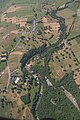
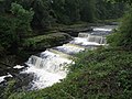
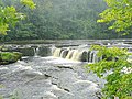
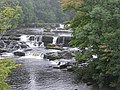
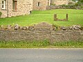
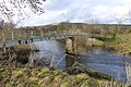
en: Aysgarth is a village and civil parish in Wensleydale, in the Richmondshire district of North Yorkshire, about 16 miles south west of Richmond. The village is in the Yorkshire Dales National Park. According to the 2001 census the parish had a population of 197. The village gives its name to the nearby Aysgarth Falls.
Subcategories
This category has the following 11 subcategories, out of 11 total.
2
A
- Aysgarth Falls (268 F)
- Aysgarth railway station (5 F)
B
F
- Flout Moor Lane (3 F)
H
T
- Thieves Gill (2 F)
Y
- Yore Bridge, Aysgarth (17 F)
- Yore Mill (16 F)
Media in category "Aysgarth"
The following 200 files are in this category, out of 342 total.
(previous page) (next page)-
 A Corner of Aysgarth - geograph.org.uk - 4114902.jpg 5,184 × 3,456; 6.34 MB
-
 A road through Aysgarth - geograph.org.uk - 5928796.jpg 2,000 × 1,417; 1.28 MB
-
 A684 (Heads Bank) opposite Nellholme House - geograph.org.uk - 3785560.jpg 1,024 × 683; 241 KB
-
 A684 at Aysgarth - geograph.org.uk - 3587201.jpg 640 × 481; 53 KB
-
 A684 in Aysgarth - geograph.org.uk - 6173896.jpg 1,024 × 683; 454 KB
-
 A684 junction east of Aysgarth - geograph.org.uk - 2960754.jpg 640 × 504; 97 KB
-
 A684 through Aysgarth - geograph.org.uk - 1961548.jpg 640 × 480; 71 KB
-
 A684 through Aysgarth - geograph.org.uk - 5413839.jpg 640 × 480; 60 KB
-
 A684 towards Leyburn - geograph.org.uk - 5413862.jpg 640 × 480; 71 KB
-
 Access Track leading to Aysgarth Mill - geograph.org.uk - 4114893.jpg 5,184 × 3,456; 6.62 MB
-
 April afternoon - geograph.org.uk - 1247844.jpg 640 × 351; 53 KB
-
 At the back of the village - geograph.org.uk - 2299881.jpg 4,000 × 3,000; 2.67 MB
-
 Autumn near the Falls - geograph.org.uk - 1554087.jpg 640 × 480; 87 KB
-
 Autumn Palette (258664225).jpeg 2,048 × 1,365; 988 KB
-
 Aysgarth - geograph.org.uk - 533197.jpg 640 × 478; 141 KB
-
 Aysgarth - geograph.org.uk - 6173894.jpg 1,024 × 683; 452 KB
-
 Aysgarth and River Ure, aerial 2018 - geograph.org.uk - 5897513.jpg 800 × 533; 114 KB
-
 Aysgarth Bridge - geograph.org.uk - 3920350.jpg 640 × 480; 122 KB
-
 Aysgarth centre - geograph.org.uk - 2960745.jpg 640 × 475; 52 KB
-
 Aysgarth Church and Cemetery - geograph.org.uk - 3965278.jpg 640 × 480; 89 KB
-
 Aysgarth Falls - geograph.org.uk - 4700945.jpg 3,628 × 2,419; 2.61 MB
-
 Aysgarth Falls Hotel - geograph.org.uk - 4298248.jpg 5,045 × 3,363; 1.44 MB
-
 Aysgarth Falls Upper - geograph.org.uk - 3344100.jpg 2,592 × 1,944; 1.55 MB
-
 Aysgarth Falls, aerial 2018 (1) - geograph.org.uk - 5897313.jpg 533 × 800; 126 KB
-
 Aysgarth Falls, aerial 2018 (2) - geograph.org.uk - 5897522.jpg 533 × 800; 145 KB
-
 Aysgarth Falls, Lower Force - geograph.org.uk - 4929634.jpg 3,072 × 1,728; 1.34 MB
-
 Aysgarth Falls, Middle Force - geograph.org.uk - 3514280.jpg 680 × 1,024; 240 KB
-
 Aysgarth Falls, Middle Force - geograph.org.uk - 4929606.jpg 3,072 × 1,728; 2.55 MB
-
 Aysgarth Garage - geograph.org.uk - 1809697.jpg 2,933 × 1,716; 807 KB
-
 Aysgarth George and Dragon.JPG 867 × 971; 180 KB
-
 Aysgarth Institute, AD 1907 - geograph.org.uk - 2515946.jpg 1,024 × 683; 140 KB
-
 Aysgarth Lower Falls - geograph.org.uk - 3671297.jpg 640 × 480; 105 KB
-
 Aysgarth Lower Falls - geograph.org.uk - 4640306.jpg 800 × 533; 174 KB
-
 Aysgarth Lower Falls - geograph.org.uk - 4640308.jpg 800 × 533; 141 KB
-
 Aysgarth Middle Falls - geograph.org.uk - 3671274.jpg 640 × 480; 111 KB
-
 Aysgarth Middle Falls - geograph.org.uk - 5574314.jpg 2,000 × 1,333; 2.63 MB
-
 Aysgarth Middle Falls on the River Ure - geograph.org.uk - 4094250.jpg 1,024 × 768; 318 KB
-
 Aysgarth Mill (6210).jpg 4,288 × 2,848; 6.03 MB
-
 Aysgarth Mill - geograph.org.uk - 539851.jpg 640 × 359; 100 KB
-
 Aysgarth Mill and Carriage Museum - geograph.org.uk - 2281468.jpg 640 × 427; 233 KB
-
 Aysgarth Mill and resident - geograph.org.uk - 1742751.jpg 640 × 480; 116 KB
-
 Aysgarth National Park Centre - geograph.org.uk - 1961543.jpg 640 × 429; 68 KB
-
 Aysgarth Surgery - geograph.org.uk - 6136305.jpg 1,024 × 683; 176 KB
-
 Aysgarth Telephone Exchange - geograph.org.uk - 2038714.jpg 3,072 × 2,304; 1.79 MB
-
 Aysgarth Upper Falls - geograph.org.uk - 2066686.jpg 640 × 481; 265 KB
-
 Aysgarth Upper Falls - geograph.org.uk - 3223273.jpg 640 × 471; 177 KB
-
 Aysgarth Upper Falls - geograph.org.uk - 3671253.jpg 640 × 480; 117 KB
-
 Aysgarth Upper Falls - geograph.org.uk - 5574296.jpg 2,000 × 1,333; 2.75 MB
-
 Aysgarth village institute - geograph.org.uk - 539864.jpg 640 × 359; 76 KB
-
 Aysgarth Youth Hostel - geograph.org.uk - 18956.jpg 640 × 438; 95 KB
-
 Aysgarth Youth Hostel - geograph.org.uk - 5490028.jpg 1,024 × 628; 142 KB
-

-
 AysgarthVillage.jpg 1,120 × 840; 448 KB
-

-
 Barn beside Flout Moor Lane - geograph.org.uk - 3581646.jpg 4,000 × 3,000; 2.76 MB
-
 Barn near Town Head Farm - geograph.org.uk - 4298540.jpg 5,400 × 3,600; 2.52 MB
-
 Barn on Heads Bank - geograph.org.uk - 4733774.jpg 6,000 × 4,000; 4.43 MB
-
 Barn on Mill Lane - geograph.org.uk - 2337801.jpg 4,000 × 3,000; 3.42 MB
-
 Barn on south side of A684 - geograph.org.uk - 3069093.jpg 1,024 × 683; 269 KB
-
 Barn on the corner of High Lane - geograph.org.uk - 2300005.jpg 4,000 × 3,000; 2.54 MB
-
 Barn on west side of Folly Lane - geograph.org.uk - 6136434.jpg 1,024 × 683; 189 KB
-
 Barn, Dyke Hollins - geograph.org.uk - 6327623.jpg 800 × 533; 164 KB
-
 Behind the houses - geograph.org.uk - 1247788.jpg 640 × 356; 50 KB
-
 Benchmark bracket on 'Churchbank House' - geograph.org.uk - 2514274.jpg 683 × 1,024; 276 KB
-
 Benchmark bracket on the Institute - geograph.org.uk - 2516408.jpg 683 × 1,024; 294 KB
-
 Benchmark by gate at entrance path to church - geograph.org.uk - 3786580.jpg 1,024 × 683; 310 KB
-
 Benchmark on a gatepost near Keld Spring - geograph.org.uk - 2968938.jpg 3,072 × 2,304; 1.27 MB
-
 Benchmark on A684 end of Harper Wath bridge - geograph.org.uk - 5210979.jpg 1,024 × 686; 205 KB
-
 Benchmark on Aysgarth Surgery - geograph.org.uk - 6136282.jpg 1,024 × 683; 237 KB
-
 Benchmark on barn beside A684 - geograph.org.uk - 3069092.jpg 1,024 × 683; 346 KB
-
 Benchmark on buttress of St Andrew's Church - geograph.org.uk - 2514262.jpg 683 × 1,024; 285 KB
-

-
 Benchmark on gatepost on SW side of A684 - geograph.org.uk - 5210944.jpg 686 × 1,024; 249 KB
-
 Benchmark on stone in wall outside Glebe Cottage - geograph.org.uk - 2516336.jpg 1,024 × 683; 336 KB
-
 Benchmark on Stow House (formerly the Vicarage) - geograph.org.uk - 2516346.jpg 683 × 1,024; 263 KB
-

-
 Benchmark on window sill on Palmer Flatt Hotel - geograph.org.uk - 2514236.jpg 1,024 × 683; 259 KB
-
 Benchmarked boundary stone beside A684 - geograph.org.uk - 3785548.jpg 683 × 1,024; 288 KB
-
 Bridge by Aysgarth Mill (6211).jpg 4,288 × 2,848; 6.36 MB
-
 Bridge near Ballowfield - geograph.org.uk - 5495824.jpg 1,024 × 683; 471 KB
-

-
 Campsite Aysgarth Falls Hotel - geograph.org.uk - 4099116.jpg 3,264 × 2,448; 4.07 MB
-
 Castle Dykes henge - geograph.org.uk - 5938971.jpg 960 × 720; 212 KB
-
 Churchbank House beside Church Bank - geograph.org.uk - 3785533.jpg 1,024 × 683; 138 KB
-
 Contented cattle - geograph.org.uk - 3493980.jpg 3,240 × 4,320; 5.7 MB
-
 Coppiced area, Freeholders Wood - geograph.org.uk - 1723632.jpg 3,264 × 2,448; 3.31 MB
-
 Coppicing in Freeholders Wood - geograph.org.uk - 1606594.jpg 640 × 409; 111 KB
-
 Coronation Memorial and Stocks - geograph.org.uk - 771445.jpg 640 × 480; 94 KB
-
 Cottage, Aysgarth - geograph.org.uk - 5413835.jpg 640 × 480; 54 KB
-
 Curious sheep in field west of Aysgarth - geograph.org.uk - 4197865.jpg 1,024 × 683; 183 KB
-
 Dales barn, Aysgarth - geograph.org.uk - 1320997.jpg 480 × 640; 85 KB
-
 Descent to the ford on Folly Lane - geograph.org.uk - 2969226.jpg 3,072 × 2,304; 1.23 MB
-

-
 Drinking trough - geograph.org.uk - 1742745.jpg 480 × 640; 111 KB
-
 Elizabeth II postbox on the A684, Aysgarth - geograph.org.uk - 5415690.jpg 1,595 × 2,742; 915 KB
-
 Entering Aysgarth on the A684 - geograph.org.uk - 3152923.jpg 800 × 600; 71 KB
-
 Entrance to 'Glebe Cottage' from A684 - geograph.org.uk - 3786640.jpg 1,024 × 683; 171 KB
-

-
 Entrance to Riddings from Tomgill Bank - geograph.org.uk - 6136412.jpg 1,024 × 683; 156 KB
-
 Ewe and lambs, Aysgarth - geograph.org.uk - 1247799.jpg 640 × 416; 70 KB
-
 Ex-youth hostel at Aysgarth - geograph.org.uk - 5243872.jpg 1,500 × 888; 1.04 MB
-
 Family fun near Aysgarth upper falls - geograph.org.uk - 4086325.jpg 1,024 × 768; 250 KB
-
 Farm buildings at Folly House - geograph.org.uk - 6364551.jpg 800 × 533; 129 KB
-
 Field and walls at Aysgarth - geograph.org.uk - 4831423.jpg 640 × 427; 83 KB
-
 Field barn and Land Rover - geograph.org.uk - 4831447.jpg 640 × 427; 77 KB
-
 Field barn near Aysgarth - geograph.org.uk - 4831438.jpg 640 × 427; 77 KB
-
 Field barn with stream - geograph.org.uk - 5244335.jpg 1,500 × 984; 1.34 MB
-
 Field Barn, Heads Bank, Aysgarth - geograph.org.uk - 6353842.jpg 800 × 533; 135 KB
-
 Fields above Seata Quarry - geograph.org.uk - 4298562.jpg 5,400 × 3,600; 2.42 MB
-
 Fields and dry stone walls - geograph.org.uk - 6361883.jpg 800 × 533; 126 KB
-
 Fields east of Folly Lane - geograph.org.uk - 4298926.jpg 5,400 × 3,600; 2.46 MB
-
 Fields near Aysgarth - geograph.org.uk - 4298508.jpg 5,400 × 3,600; 3.52 MB
-
 Flattlands, Aysgarth - geograph.org.uk - 5831571.jpg 2,470 × 1,853; 1,007 KB
-
 Flout Moor Lane (West) - geograph.org.uk - 204631.jpg 640 × 480; 91 KB
-
 Flout Moor Lane - geograph.org.uk - 1320837.jpg 640 × 480; 77 KB
-
 Flout Moor Lane - geograph.org.uk - 3439428.jpg 4,000 × 3,000; 3.68 MB
-
 Flout Moor Lane - geograph.org.uk - 5938966.jpg 960 × 720; 177 KB
-
 Folly House - geograph.org.uk - 1320858.jpg 640 × 480; 87 KB
-
 Folly Lane - geograph.org.uk - 205231.jpg 640 × 480; 89 KB
-
 Folly Lane - geograph.org.uk - 4298927.jpg 5,400 × 3,600; 3.16 MB
-
 Foot bridge over the River Ure - geograph.org.uk - 5413747.jpg 640 × 443; 75 KB
-
 Footbridge over the River Ure - geograph.org.uk - 4114878.jpg 5,184 × 3,456; 7.78 MB
-
 Footbridge over the River Ure - geograph.org.uk - 6000997.jpg 1,600 × 1,067; 436 KB
-
 Footbridge, Gill Beck - geograph.org.uk - 5249571.jpg 640 × 480; 88 KB
-
-

-
 Footpath leading to Tomgill Bridge - geograph.org.uk - 4114912.jpg 5,184 × 3,456; 6.65 MB
-
 Footpath to Tomgill Bridge - geograph.org.uk - 1247835.jpg 640 × 480; 70 KB
-
 Former water mill - geograph.org.uk - 1554433.jpg 640 × 480; 86 KB
-
 Freeholders Wood - geograph.org.uk - 1723614.jpg 2,448 × 3,264; 3.65 MB
-
 Garths Lane - geograph.org.uk - 5132095.jpg 3,264 × 1,836; 2.26 MB
-
 Gate across Flout Moor Lane - geograph.org.uk - 5244914.jpg 1,500 × 852; 1.24 MB
-
 Gate through wall, Flout Moor - geograph.org.uk - 4512838.jpg 640 × 480; 78 KB
-
 Gateway from A684 at Heads Bank - geograph.org.uk - 3786749.jpg 1,024 × 683; 173 KB
-
 Gateway on Flout Moor Lane - geograph.org.uk - 4461622.jpg 4,320 × 3,240; 3.66 MB
-
 Gateway on Garths Lane - geograph.org.uk - 3072208.jpg 1,024 × 683; 152 KB
-
 George and Dragon Aysgarth - geograph.org.uk - 1961551.jpg 640 × 480; 83 KB
-
 Gill Beck - geograph.org.uk - 2337166.jpg 2,274 × 1,840; 1.51 MB
-
 Grazing and barns near Seata Farm - geograph.org.uk - 5413739.jpg 640 × 480; 41 KB
-
 Green (or yellow) lane, Seata - geograph.org.uk - 1320934.jpg 640 × 480; 103 KB
-
 Green Lane to Seata Quarry - geograph.org.uk - 204621.jpg 640 × 480; 108 KB
-
 Harper Wath - geograph.org.uk - 4459920.jpg 3,872 × 2,592; 4.78 MB
-
 Haw Beck crossing Flout Moor Lane - geograph.org.uk - 5244926.jpg 1,500 × 878; 1.18 MB
-
 Head of Tom Gill - geograph.org.uk - 1320880.jpg 640 × 341; 43 KB
-
 Hestholme Farm - geograph.org.uk - 910626.jpg 640 × 480; 120 KB
-
 High Force at Aysgarth Falls - geograph.org.uk - 6001025.jpg 1,600 × 1,067; 314 KB
-
 High Force waterfalls Aysgarth - geograph.org.uk - 3344105.jpg 2,592 × 1,944; 1.66 MB
-
 High Force, Aysgarth - geograph.org.uk - 5494337.jpg 1,024 × 576; 426 KB
-
 High Force, Aysgarth - geograph.org.uk - 5494343.jpg 1,024 × 576; 373 KB
-
 High Force, Aysgarth - geograph.org.uk - 5539746.jpg 1,280 × 853; 520 KB
-
 High Gill bridge - geograph.org.uk - 3338254.jpg 2,048 × 1,536; 1.22 MB
-
 House on edge of Aysgarth - geograph.org.uk - 4831426.jpg 640 × 427; 114 KB
-
 House on the A684, Aysgarth - geograph.org.uk - 5415694.jpg 640 × 480; 53 KB
-
 Houses in Aysgarth (6213).jpg 4,288 × 2,848; 6.99 MB
-
 Houses in Aysgarth (6214).jpg 4,288 × 2,848; 6.67 MB
-
 Houses in Aysgarth (6215).jpg 4,288 × 2,848; 6.33 MB
-
 Houses in Aysgarth (6216).jpg 4,288 × 2,848; 5.53 MB
-
 Houses in Aysgarth (6217).jpg 4,288 × 2,848; 6.28 MB
-
 Houses in Aysgarth (6218).jpg 4,288 × 2,848; 6.1 MB
-
 Image taken from page 5 of 'Wensleydale and Swaledale Guide ... Illustrated' (11234482436).jpg 1,252 × 2,300; 1,007 KB
-
 Inverted benchmark on wall of Garths Lane - geograph.org.uk - 3072174.jpg 683 × 1,024; 305 KB
-
 Kitty's Tea Room, Aysgarth - geograph.org.uk - 1802310.jpg 640 × 480; 72 KB
-
 Lambs pose in the sunshine - geograph.org.uk - 2343067.jpg 1,367 × 1,024; 422 KB
-
 Little White Building - geograph.org.uk - 2300081.jpg 1,241 × 1,024; 400 KB
-
 Lone tree in field near Aysgarth - geograph.org.uk - 5246272.jpg 1,500 × 1,125; 1.65 MB
-
 Looking downriver from the top of the Lower Falls - geograph.org.uk - 5795683.jpg 4,608 × 3,456; 6.87 MB
-
 Looking towards Yore Bridge from Church Bank - geograph.org.uk - 3785356.jpg 1,024 × 683; 255 KB
-
 Looking west along Flout Mill Lane - geograph.org.uk - 6136455.jpg 1,024 × 683; 257 KB
-
 Lower Aysgarth Falls - geograph.org.uk - 5197303.jpg 2,399 × 1,599; 691 KB
-
 Lower Aysgarth Falls - geograph.org.uk - 5197306.jpg 2,399 × 1,599; 646 KB
-
 Lower Falls at Aysgarth - geograph.org.uk - 5795679.jpg 4,608 × 3,456; 4.52 MB
-
 Lower Falls, Aysgarth - geograph.org.uk - 4298433.jpg 5,400 × 3,600; 2.81 MB
-
 Lower Falls, Aysgarth in 1987 - geograph.org.uk - 2745439.jpg 836 × 557; 113 KB
-
 Lower Force - geograph.org.uk - 5495791.jpg 1,024 × 683; 475 KB
-
 Lower Force at Aygarth Falls - geograph.org.uk - 6001033.jpg 1,600 × 1,067; 322 KB
-
 Lower Force on Aysgarth Falls - geograph.org.uk - 4993220.jpg 3,953 × 2,965; 5.99 MB
-
 Lowgill Bridge - geograph.org.uk - 2337159.jpg 3,296 × 2,472; 2.42 MB
-

-

-
 Memorial plaque above Aysgarth Falls - geograph.org.uk - 4170859.jpg 640 × 480; 167 KB
-
 Middle Falls, Aysgarth - geograph.org.uk - 4298425.jpg 4,652 × 3,101; 2.43 MB
-
 Middle Force Aysgarth - geograph.org.uk - 3344144.jpg 2,592 × 1,944; 1.58 MB
-
 Middle Force, Aysgarth Falls - geograph.org.uk - 3514283.jpg 1,024 × 680; 188 KB
-
 Mill Race at Aysgarth - geograph.org.uk - 355792.jpg 640 × 480; 130 KB
-
 Mill Race at Yore Mill - geograph.org.uk - 1606584.jpg 480 × 640; 133 KB
-
 Minor falls at Aysgarth - geograph.org.uk - 4831406.jpg 640 × 427; 133 KB
-
 Minor repairs - geograph.org.uk - 2299897.jpg 4,000 × 3,000; 2.42 MB
-
 Mystery stone 2 - geograph.org.uk - 2337871.jpg 2,004 × 2,668; 2.12 MB
-
 Nellholme House - geograph.org.uk - 883810.jpg 640 × 371; 58 KB
-
 Old holloway near Aysgarth - geograph.org.uk - 1247872.jpg 480 × 640; 78 KB
-
 Old limekiln, Seata Quarry - geograph.org.uk - 1320919.jpg 480 × 640; 157 KB
-
 Old mill race gates above upper Aysgarth Falls, High Force - geograph.org.uk - 4928934.jpg 3,072 × 1,728; 2.54 MB
-
 Old Mill, River Ure, Aysgarth Falls, Wensleydale, Yorkshire (26888076411).jpg 7,360 × 3,750; 14.17 MB
-
 Old plough strips, Aysgarth - geograph.org.uk - 2337827.jpg 3,578 × 2,000; 1.31 MB
-
 Ordnance Survey Flush Bracket S0623 - geograph.org.uk - 3439790.jpg 4,000 × 3,000; 2.69 MB
-
 Ordnance Survey Flush Bracket S8102 - geograph.org.uk - 3439776.jpg 4,000 × 3,000; 4.63 MB
-
 Outcrop of Carboniferous Limestone - geograph.org.uk - 4473015.jpg 3,296 × 2,472; 1.94 MB
-

-
 Palmer Flatt Hotel - geograph.org.uk - 2514242.jpg 1,024 × 683; 240 KB
-
 Palmer Flatt Hotel on A684 - geograph.org.uk - 1961547.jpg 640 × 480; 76 KB


_opposite_Nellholme_House_-_geograph.org.uk_-_3785560.jpg)


.jpeg)


_-_geograph.org.uk_-_5897313.jpg)
_-_geograph.org.uk_-_5897522.jpg)


.jpg)


_-_geograph.org.uk_-_2516346.jpg)


.jpg)


_-_geograph.org.uk_-_204631.jpg)


_lane,_Seata_-_geograph.org.uk_-_1320934.jpg)


.jpg)
.jpg)
.jpg)
.jpg)
.jpg)
.jpg)
.jpg)


.jpg)


