Category:Autobahnkirche Dolina
Jump to navigation
Jump to search
| Object location | | View all coordinates using: OpenStreetMap |
|---|
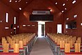
building in Grafenstein, Austria  _-_Kirche,_Innenansicht.JPG) Interior view of the church in Dolina | |||||
| Upload media | |||||
| Instance of | |||||
|---|---|---|---|---|---|
| Location | Q1235585, Grafenstein, Klagenfurt-Land District, Carinthia, Austria | ||||
| Heritage designation | |||||
 | |||||
Media in category "Autobahnkirche Dolina"
The following 28 files are in this category, out of 28 total.
-
 Dolina (Grafenstein) - Kirche, Innenansicht.JPG 6,300 × 4,200; 8.57 MB
-
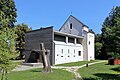 Dolina (Grafenstein) - Kirche.JPG 4,800 × 3,200; 9.86 MB
-
 Dolina 3653.JPG 3,434 × 2,287; 3.69 MB
-
 Dolina 3657.jpg 3,285 × 2,189; 1.5 MB
-
 Dolina 3661.JPG 3,888 × 2,592; 3.16 MB
-
 Dolina 3671.jpg 3,906 × 2,602; 1.65 MB
-
 Dolina 3672.jpg 1,198 × 1,805; 404 KB
-
 Dolina 3681.jpg 2,079 × 3,120; 1.7 MB
-
 Dolina 3690.jpg 3,594 × 2,397; 1.85 MB
-
 Dolina 3718.jpg 3,906 × 2,602; 1.85 MB
-
 Dolina, Carinthia-Austria 1.JPG 4,000 × 3,000; 2.53 MB
-
 Dolina, Carinthia-Austria 2.JPG 4,000 × 3,000; 2.31 MB
-
 Dolina, Carinthia-Austria 3 glavni oltar.JPG 3,000 × 4,000; 2.47 MB
-
 Dolina, Carinthia-Austria 4.JPG 3,000 × 4,000; 2.62 MB
-
 Dolina, Carinthia-Austria 5.JPG 3,000 × 4,000; 2.71 MB
-
 Dolina, Carinthia-Austria 6.JPG 4,000 × 3,000; 1.78 MB
-
 Dolina, Carinthia-Austria 7.JPG 4,000 × 3,000; 2.51 MB
-
 Dolina, Carinthia-Austria 8.JPG 4,000 × 3,000; 2.35 MB
-
 Grafenstein Dolina Autobahnkirche Maria im Walde 22092011 101.jpg 4,288 × 2,848; 3.78 MB
-
 Grafenstein Dolina Autobahnkirche Maria im Walde Altarbild 22092011 126.jpg 2,848 × 4,288; 2.82 MB
-
 Grafenstein Dolina Autobahnkirche Maria im Walde Inneres 20062016 2707.jpg 7,360 × 4,912; 18.11 MB
-
 Grafenstein Dolina Autobahnkirche Maria im Walde Inneres 22092011 111.jpg 4,288 × 2,848; 1.96 MB
-
 Grafenstein Dolina Autobahnkirche Maria im Walde NO-Ansicht 20062016 2697.jpg 7,360 × 4,912; 17.23 MB
-
 Grafenstein Dolina Autobahnkirche Maria im Walde SO-Ansicht 20062016 2692.jpg 6,647 × 4,912; 17.18 MB
-
 Grafenstein Dolina Autobahnkirche Maria im Walde SW-Ansicht 20062016 2683.jpg 7,360 × 4,912; 22.63 MB
-
 Grafenstein Dolina Autobahnkirche Maria im Walde W-Ansicht 20062016 2705.jpg 6,534 × 4,568; 15.46 MB
-
 Grafenstein Dolina Autobahnkirche Maria im Walde Altar 22092011 120.jpg 2,794 × 4,207; 1.13 MB
-
 Grafenstein Dolina Autobahnkirche Maria im Walde Inneres 22092011 113.jpg 4,288 × 2,848; 2.48 MB
_-_Kirche.JPG)


