Category:Aussichtsturm Mescherin
Jump to navigation
Jump to search
| Object location | | View all coordinates using: OpenStreetMap |
|---|
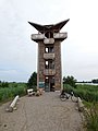
observation tower at Oder river near Mescherin  | |||||
| Upload media | |||||
| Instance of | |||||
|---|---|---|---|---|---|
| Made from material | |||||
| Location | Mescherin, Uckermark District, Brandenburg, Germany | ||||
| Height |
| ||||
 | |||||
Media in category "Aussichtsturm Mescherin"
The following 2 files are in this category, out of 2 total.
-
 Nationalpark Unteres Odertal, Aussichtsturm in Mescherin.jpg 3,456 × 4,608; 3.64 MB
-
 TurmMescherin.jpg 619 × 1,080; 119 KB
