Category:August 2007 in Herefordshire
Jump to navigation
Jump to search
Deutsch: Bilder, die im August 2007 in Herefordshire aufgenommen worden sind. Bitte beachten Sie, dass dies weder das Datum des Uploads noch das Datum des Scannens eines Fotos ist.
English: Images/pictures taken in Herefordshire during August 2007. Note this is not the date of the upload, nor the date a photo was scanned.
Español: Fotografías o imágenes tomadas en Herefordshire durante agosto 2007. No es la fecha de subida ni escaneo, sino la fecha en que las fotografías o imágenes se crearon.
Esperanto: Bildoj faritaj en Herefordshire en aŭgusto 2007. Tio ne estas la dato, kiam la bildoj estis alŝutitaj aŭ skanitaj.
Français : Photographies ou images prises en Herefordshire durant août 2007. Ce n'est pas la date du téléchargement ou du scan.
Galego: Fotografías ou imaxes tomadas en Herefordshire durante agosto 2007. Non é a data de subida nin escaneamento, senón a data na que se crearon as fotografías ou imaxes.
Italiano: Fotografie o immagini scattate a Herefordshire nel agosto 2007. Nota bene: la data non si riferisce né a quella di upload né a quella in cui la foto è stata digitalizzata.
Norsk bokmål: Bilder tatt i Herefordshire i løpet av august 2007. Merk at dette ikke er datoen for opplasting, eller når et bilde har blitt skannet.
Norsk nynorsk: Bilete teke i Herefordshire i løpet av august 2007. Merk at dette ikkje er datoen for opplasting, eller når eit bilete har vorte skanna.
Русский: Изображения, сделанные в Herefordshire в течение август 2007 (не дата загрузки изображения).
Українська: Зображення, зроблені в Herefordshire протягом серпень 2007. Зауважте, що це не дата завантаження чи дата сканування фотографії.
| August 2006 | ← | August 2007 | → | August 2008 | |||||||
| Jan | Feb | Mar | Apr | May | Jun | Jul | Aug | Sep | Oct | Nov | Dec |
| 51 | 62 | 99 | 75 | 60 | 82 | 72 | 81 | 50 | 36 | 31 | 77 |
|---|---|---|---|---|---|---|---|---|---|---|---|
Media in category "August 2007 in Herefordshire"
The following 81 files are in this category, out of 81 total.
-
 The Bell, Yarpole - geograph.org.uk - 532429.jpg 640 × 426; 424 KB
-
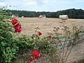 Bales at Lower Tedgewood Farm - geograph.org.uk - 528636.jpg 640 × 480; 125 KB
-
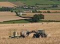
 Baling time - geograph.org.uk - 515414.jpg 640 × 472; 443 KB
-

-
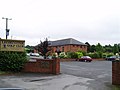
 Bridstow Parish Hall - geograph.org.uk - 520207.jpg 640 × 445; 290 KB
-
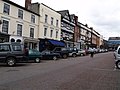 Broad Street - geograph.org.uk - 958018.jpg 640 × 480; 66 KB
-
 Bromyard Road Trading Estate, Ledbury - geograph.org.uk - 515130.jpg 640 × 427; 268 KB
-
 Church Street from the church steps - geograph.org.uk - 515030.jpg 640 × 480; 352 KB
-
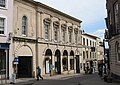 Corn Exchange, High Street - geograph.org.uk - 515053.jpg 640 × 454; 318 KB
-
 Corn square - geograph.org.uk - 958032.jpg 640 × 480; 82 KB
-
 Cross Inn at Eardisland - geograph.org.uk - 945132.jpg 640 × 480; 82 KB
-
 Dog guarding the barn - geograph.org.uk - 538453.jpg 640 × 462; 85 KB
-
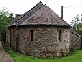
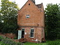 Dovecot - geograph.org.uk - 945113.jpg 640 × 480; 118 KB
-
 Footbridge north of Mathon - geograph.org.uk - 565603.jpg 640 × 480; 142 KB
-
 Footpath steps into Thomas Wood - geograph.org.uk - 524676.jpg 480 × 640; 412 KB
-
 Ford church - geograph.org.uk - 914387.jpg 640 × 480; 56 KB
-
 Ford church - geograph.org.uk - 914388.jpg 640 × 480; 78 KB
-
 Ford church - geograph.org.uk - 914389.jpg 640 × 480; 54 KB
-
 Ford church - geograph.org.uk - 914390.jpg 640 × 480; 102 KB
-
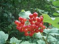 Guelder Rose in Queen's Wood - geograph.org.uk - 528608.jpg 640 × 480; 95 KB
-
 Heart of Oak pub, Hereford - geograph.org.uk - 531182.jpg 640 × 480; 49 KB
-
 Hergest court - geograph.org.uk - 928762.jpg 640 × 480; 86 KB
-
 Hergest court - geograph.org.uk - 957987.jpg 640 × 480; 73 KB
-
 Hergest court - geograph.org.uk - 957988.jpg 640 × 480; 88 KB
-
 Inn on the Wye - geograph.org.uk - 524628 (cropped).jpg 543 × 305; 213 KB
-
 Inn on the Wye - geograph.org.uk - 524628.jpg 544 × 640; 353 KB
-
 Leominster golf club - geograph.org.uk - 914392.jpg 640 × 480; 46 KB
-

-
 Power lines NW of May Hill - geograph.org.uk - 522466.jpg 640 × 482; 297 KB
-

-
 River outside the Dovecot - geograph.org.uk - 945139.jpg 640 × 480; 128 KB
-
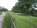
 Road bridge over the dismantled railway - geograph.org.uk - 530451.jpg 640 × 478; 120 KB
-
 Road to Stoke Prior from Ford Bridge - geograph.org.uk - 525036.jpg 640 × 440; 356 KB
-
 Rounding up the bales - geograph.org.uk - 519895.jpg 640 × 477; 127 KB
-
 Seat on the Worcestershire Way - geograph.org.uk - 522257.jpg 640 × 427; 301 KB
-
 Shade seeking sheep - geograph.org.uk - 517807.jpg 640 × 480; 420 KB
-
 Shobdon airdrome - geograph.org.uk - 913273.jpg 640 × 480; 28 KB
-
 Wood ant nest in Queen's Wood - geograph.org.uk - 528613.jpg 640 × 480; 151 KB
-
 Woodland Trail in Haugh Wood - geograph.org.uk - 537845.jpg 640 × 480; 146 KB
-
 Wye Valley Walk footpath... - geograph.org.uk - 524667.jpg 472 × 640; 411 KB
-
 Yatton View - geograph.org.uk - 653177 (cropped).jpg 505 × 337; 55 KB
-
 Yatton View - geograph.org.uk - 653177.jpg 640 × 427; 90 KB
-
 August Harvest near Uplands Farm - geograph.org.uk - 513744.jpg 640 × 427; 250 KB
-
 Caravan site at Lyndor - geograph.org.uk - 566750.jpg 640 × 480; 95 KB
-
 Catley Cattle - geograph.org.uk - 529889 (cropped).jpg 640 × 120; 23 KB
-
 Catley Cattle - geograph.org.uk - 529889.jpg 640 × 480; 63 KB
-
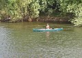 Dog paddle - geograph.org.uk - 523372.jpg 640 × 453; 439 KB
-
 Entrance to Lyndor Cottages - geograph.org.uk - 566748.jpg 640 × 480; 128 KB
-
 Farmland, late evening in August - geograph.org.uk - 513209.jpg 480 × 640; 300 KB
-
 Footpath and sheep tracks - geograph.org.uk - 517474.jpg 640 × 480; 371 KB
-

-
 Footpath to Camp Farm - geograph.org.uk - 548313.jpg 640 × 480; 89 KB
-
 Footpaths near Whittlebury Farm - geograph.org.uk - 538469.jpg 640 × 563; 119 KB
-
 Grazing land off the B4224 near Lea - geograph.org.uk - 534984.jpg 640 × 480; 74 KB
-
 Haugh Woods - geograph.org.uk - 537821.jpg 640 × 442; 135 KB
-
 Hay crop at the foot of Cockshot Hill - geograph.org.uk - 565619.jpg 640 × 480; 119 KB
-
 Hay crop near Queen's Wood - geograph.org.uk - 528651.jpg 640 × 480; 121 KB
-
 Hay Meadow - geograph.org.uk - 513892.jpg 640 × 427; 235 KB
-
 Hay Meadow - geograph.org.uk - 514751.jpg 640 × 427; 298 KB
-
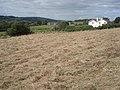
 House at Tedgewood - geograph.org.uk - 528642.jpg 640 × 480; 69 KB
-
 Lane at Catley - geograph.org.uk - 529952.jpg 640 × 480; 125 KB
-
 Lane at Lyndor Wood - geograph.org.uk - 566743.jpg 640 × 480; 75 KB
-
 Lane near Notehouse Farm - geograph.org.uk - 529953.jpg 640 × 480; 106 KB
-
 Lane to Strangford - geograph.org.uk - 566046.jpg 640 × 480; 69 KB
-
 Late evening on the golf course - geograph.org.uk - 514174.jpg 640 × 472; 316 KB
-
 Late hay crop near Daubies Farm - geograph.org.uk - 528646.jpg 640 × 480; 118 KB
-

-
 Lyndor Cottages - geograph.org.uk - 566745.jpg 640 × 480; 125 KB
-
 Maize Field near Peg's Farm - geograph.org.uk - 513775.jpg 640 × 427; 248 KB
-
 Over Ross Street, Ross-on-Wye - geograph.org.uk - 514073.jpg 480 × 640; 354 KB
-
 Paddocks at Tedgewood - geograph.org.uk - 528632.jpg 640 × 480; 91 KB
-
 Path junction at Queen's Wood - geograph.org.uk - 528605.jpg 640 × 480; 132 KB
-
 Queen's Wood forestry track - geograph.org.uk - 528604.jpg 480 × 640; 119 KB
-
 Quiet please^ - geograph.org.uk - 528625.jpg 640 × 480; 66 KB
-
 River Wye at Lyndor - geograph.org.uk - 566753.jpg 640 × 480; 110 KB
-
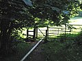
 Start of the footpath to Pict's Cross - geograph.org.uk - 520654.jpg 640 × 480; 349 KB
-
 Stile and Bridge Over the Cradley Brook - geograph.org.uk - 514782.jpg 640 × 407; 325 KB
-
 Stile to overgrown footpath - geograph.org.uk - 517506.jpg 480 × 640; 579 KB
-
 Stile with mysterious pipe - geograph.org.uk - 517516.jpg 640 × 480; 400 KB
-

-
 The pipeline has been laid - geograph.org.uk - 566044.jpg 640 × 480; 76 KB


.jpg)


.jpg)


.jpg)