Category:Ashleyhay
Jump to navigation
Jump to search
village and civil parish in Amber Valley district, Derbyshire, England .jpg) | |||||
| Upload media | |||||
| Instance of | |||||
|---|---|---|---|---|---|
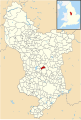
| Location | Amber Valley, Derbyshire, East Midlands, England | ||||
 | |||||
Media in category "Ashleyhay"
The following 109 files are in this category, out of 109 total.
-

-
 A dig at Broadgates Farm - geograph.org.uk - 1752955.jpg 640 × 480; 96 KB
-
 A guide stoop at Alport Height - geograph.org.uk - 1752998.jpg 640 × 480; 79 KB
-
 Alport Height motocross course - geograph.org.uk - 3903308.jpg 2,000 × 1,500; 1.12 MB
-

-
 Alport Heights - Leaving the Car Park - geograph.org.uk - 967850.jpg 640 × 480; 60 KB
-
 Alport Heights - View of the Alport Stone - geograph.org.uk - 968635.jpg 640 × 480; 100 KB
-
 Alport Heights panorama - geograph.org.uk - 2086845.jpg 1,600 × 370; 186 KB
-
 AlportStone(JohnDarch)Dec2005.jpg 480 × 640; 100 KB
-
 Alton Brook - geograph.org.uk - 4924494.jpg 640 × 480; 103 KB
-
 Ashleyhay and surrounding countryside - geograph.org.uk - 3008507.jpg 1,600 × 1,200; 490 KB
-
 B5023 towards Wirksworth - geograph.org.uk - 3996908.jpg 640 × 480; 63 KB
-
 Back Lane and Masts near Alport Height - geograph.org.uk - 3274945.jpg 4,000 × 3,000; 1.95 MB
-
 Back Lane, Alport Lane - geograph.org.uk - 1752969.jpg 640 × 480; 38 KB
-
 Barnsley Lane - geograph.org.uk - 2489340.jpg 3,296 × 2,472; 1.11 MB
-
 Barnsley Lane - geograph.org.uk - 3121737.jpg 2,048 × 1,536; 1.08 MB
-
 Barnsley Lane - geograph.org.uk - 3400299.jpg 750 × 563; 181 KB
-
 Barnsley Lane Bridge - geograph.org.uk - 5472036.jpg 1,280 × 960; 625 KB
-
 Bent Lane - geograph.org.uk - 6420222.jpg 640 × 480; 112 KB
-
 Brownhouse Farm - geograph.org.uk - 1753108.jpg 640 × 480; 68 KB
-
 Brownhouse Farm - geograph.org.uk - 3121719.jpg 2,048 × 1,536; 866 KB
-
 Brownhouse Farm - geograph.org.uk - 6377860.jpg 3,008 × 2,000; 3.94 MB
-
 Brownhouse Wood and some shorn sheep - geograph.org.uk - 5472008.jpg 1,280 × 960; 354 KB
-
 Bunk Barn at New Buildings Farm - geograph.org.uk - 6420711.jpg 2,790 × 1,493; 1.2 MB
-
 Bunk Barn at New Buildings Farm - geograph.org.uk - 6421247.jpg 640 × 480; 101 KB
-
 Car park at Alford Height - geograph.org.uk - 3121642.jpg 2,014 × 1,510; 509 KB
-
 Cattle with no blade of grass - geograph.org.uk - 1740712.jpg 640 × 480; 62 KB
-

-
 Coneygreave Farm and Alport Height - geograph.org.uk - 3153627.jpg 1,024 × 768; 406 KB
-
 Crossroads at Sandhall Lane - geograph.org.uk - 3274088.jpg 4,000 × 3,000; 2.67 MB
-
 Crossroads on Sandhall Lane - geograph.org.uk - 6420742.jpg 4,829 × 3,556; 3.82 MB
-
 Derby Road crosses the Ecclesbourne Valley Railway - geograph.org.uk - 4926902.jpg 2,000 × 1,500; 324 KB
-
 Derbyshire UK parish map highlighting Ashleyhay.svg 888 × 1,308; 2.34 MB
-
 Detail of masts, Alport Height - geograph.org.uk - 3153637.jpg 782 × 1,024; 387 KB
-
 Ecclesbourne Valley Railway - geograph.org.uk - 3996909.jpg 640 × 480; 105 KB
-
 Entrance to Colebrook Farm - geograph.org.uk - 1748988.jpg 640 × 480; 71 KB
-
 Farm and countryside near Ashleyhay - geograph.org.uk - 3400266.jpg 750 × 563; 92 KB
-
 Farm bridge over the Ecclesbourne - geograph.org.uk - 5472044.jpg 1,280 × 960; 519 KB
-
 Farmhouse at bottom of Lane End - geograph.org.uk - 1753122.jpg 640 × 480; 83 KB
-
 Farmland scene near Ashleyhay - geograph.org.uk - 3400251.jpg 750 × 563; 112 KB
-

-
 Fields towards Spencer Barn - geograph.org.uk - 3153624.jpg 1,024 × 768; 423 KB
-
 Footpath with view - geograph.org.uk - 3121667.jpg 2,048 × 1,536; 829 KB
-
 Footpath, with stile dated 1870 - geograph.org.uk - 3135441.jpg 2,048 × 1,536; 1,010 KB
-
 Former chapel by Bent Farm - geograph.org.uk - 6420747.jpg 3,387 × 1,737; 1.62 MB
-
 Hamlet of Spout from the south - geograph.org.uk - 3153641.jpg 1,024 × 461; 289 KB
-
 Hay Lane in March sunshine - geograph.org.uk - 6420737.jpg 5,160 × 3,735; 5.45 MB
-
 Hillside with Brownhouse Farm - geograph.org.uk - 3400335.jpg 750 × 563; 93 KB
-
 Junction of Knob, Hay and Alport Lanes - geograph.org.uk - 6420739.jpg 5,120 × 2,448; 4.58 MB
-
 Lane corner with remains of snowdrift - geograph.org.uk - 3400289.jpg 750 × 563; 157 KB
-
 Lane Junction near Colebrook Farm - geograph.org.uk - 1191007.jpg 640 × 480; 97 KB
-
 Lane near New Buildings Farm - geograph.org.uk - 2489338.jpg 3,296 × 2,472; 1.1 MB
-
 Malinscommon Lane - geograph.org.uk - 3135613.jpg 2,048 × 1,536; 610 KB
-
 Malinscommon Lane - geograph.org.uk - 6420724.jpg 3,227 × 1,732; 1.69 MB
-
 Masts on Alport Height - geograph.org.uk - 6420728.jpg 3,263 × 1,739; 974 KB
-
 Near Bowmerlane - geograph.org.uk - 3153646.jpg 1,024 × 768; 436 KB
-
 New Buildings Farm - geograph.org.uk - 3135411.jpg 2,048 × 1,536; 905 KB
-
 New gate on the Ecclesbourne Way - geograph.org.uk - 5454545.jpg 1,280 × 960; 627 KB
-
 Norman Hill Farm - geograph.org.uk - 3121706.jpg 2,048 × 1,536; 941 KB
-
 Oilseed rape crop - geograph.org.uk - 3996905.jpg 640 × 480; 115 KB
-
 Old gatepost - geograph.org.uk - 3121694.jpg 2,048 × 1,536; 961 KB
-
 On Hay Lane, near Wirksworth - geograph.org.uk - 1752288.jpg 640 × 480; 76 KB
-
 On Roughpiece Lane - geograph.org.uk - 6420740.jpg 5,184 × 3,888; 5.29 MB
-
 Ordnance Survey Map from the 20th century of Ashleyhay, Derbyshire.png 1,102 × 648; 1.44 MB
-
 Ordnance Survey Map of Ashleyhay Location.PNG 437 × 322; 370 KB
-
 Part Time Ford at Ashleyhay - geograph.org.uk - 3433038.jpg 3,264 × 2,448; 4.43 MB
-

-
 Path leading to Taylor's Lane - geograph.org.uk - 6420717.jpg 3,648 × 1,744; 3.19 MB
-
 Permissive path to Alport Height - geograph.org.uk - 5454550.jpg 1,280 × 960; 652 KB
-
 Radio masts, Alport Height - geograph.org.uk - 3903301.jpg 2,000 × 1,478; 570 KB
-
 Rough Pasture - geograph.org.uk - 6268938.jpg 2,000 × 1,330; 3.03 MB
-
 Roughpiece Lane - geograph.org.uk - 3274080.jpg 4,000 × 3,000; 1.6 MB
-
 Ruined barn on Spout Lane - geograph.org.uk - 6420228.jpg 640 × 480; 95 KB
-
 Ruined farm building by Malinscommon Lane - geograph.org.uk - 5454556.jpg 1,280 × 960; 499 KB
-
 Sandhall Farm - geograph.org.uk - 6420746.jpg 5,037 × 3,581; 4.48 MB
-
 Sandyford Lane - geograph.org.uk - 968026.jpg 640 × 480; 73 KB
-
 Sandyford Lane - geograph.org.uk - 968880.jpg 640 × 480; 79 KB
-

-
 Showmans' Caravan at New Buildings Farm - geograph.org.uk - 6420714.jpg 3,648 × 1,744; 3.19 MB
-
 Spendlove Farm.jpg 3,008 × 2,000; 3.72 MB
-
 Spout Lane - View of Alport Heights - geograph.org.uk - 968643.jpg 640 × 480; 106 KB
-
 Spout, a small hamlet - geograph.org.uk - 1753008.jpg 640 × 480; 37 KB
-
 Squeeze stile on the path to Brownhouse Farm - geograph.org.uk - 5472003.jpg 1,280 × 960; 520 KB
-
 Stable block and footpath - geograph.org.uk - 5454530.jpg 1,280 × 960; 623 KB
-
 Storer Farm - geograph.org.uk - 6377867.jpg 3,008 × 2,000; 4 MB
-
 Storer Farm.jpg 750 × 568; 126 KB
-
 Taylor's Lane by Holehouse Farm - geograph.org.uk - 6420707.jpg 3,648 × 1,744; 2.38 MB
-
 Taylors Lane, Ashleyhay in The Amber Valley - geograph.org.uk - 6020068.jpg 5,067 × 3,708; 4.73 MB
-
 The Alport Stone and Telecom masts - geograph.org.uk - 1752991.jpg 640 × 480; 54 KB
-
 The Alport Stone, in a disused quarry - geograph.org.uk - 3903286.jpg 2,000 × 1,500; 1.06 MB
-
 The hamlet of Spout - geograph.org.uk - 6020077.jpg 5,082 × 3,492; 4.52 MB
-
 The topograph on Alport Height - geograph.org.uk - 3903291.jpg 2,000 × 1,713; 993 KB
-
 Towards Alport Height - geograph.org.uk - 5844993.jpg 2,000 × 1,333; 2.32 MB
-
 Towards Hilltop - geograph.org.uk - 3153649.jpg 600 × 800; 136 KB
-
 Track to Little Broadgates - geograph.org.uk - 3135596.jpg 2,048 × 1,536; 1.09 MB
-
 Track to Norman Hill Farm - geograph.org.uk - 1753165.jpg 640 × 480; 57 KB
-
 Track to Norman Hill Farm - geograph.org.uk - 6020774.jpg 5,017 × 3,458; 2.86 MB
-
 Trig point and masts on Alport Heights - geograph.org.uk - 2792267.jpg 680 × 1,024; 116 KB
-
 Valley view from Barnsley Lane - geograph.org.uk - 3400312.jpg 750 × 563; 111 KB
-
 Very basic footbridge - geograph.org.uk - 3121676.jpg 2,048 × 1,536; 1.05 MB
-
 View from Back Lane - geograph.org.uk - 3153632.jpg 800 × 600; 126 KB
-
 View from Hilltop - geograph.org.uk - 3153653.jpg 1,024 × 768; 485 KB
-
 View from Hilltop - geograph.org.uk - 3153658.jpg 1,024 × 697; 365 KB
-
 View from Mailinscommon Lane - geograph.org.uk - 6420224.jpg 640 × 480; 93 KB
-
 View to a farm south of Spout - geograph.org.uk - 6020076.jpg 3,888 × 5,184; 5.84 MB
-
 View to Brownhouse Farm - geograph.org.uk - 6020074.jpg 5,010 × 3,713; 6.95 MB
-
 View to New Buildings Farm, Ashleyhay - geograph.org.uk - 6020072.jpg 3,833 × 4,919; 6.88 MB
-
 View to The Smithy on Sandhall Lane - geograph.org.uk - 6421024.jpg 4,950 × 3,632; 5.12 MB
-
 Woods and fields near Holehouse Farm - geograph.org.uk - 3135578.jpg 2,048 × 1,536; 990 KB


Dec2005.jpg)


