Category:Ashleworth
Jump to navigation
Jump to search
village and civi parish in Gloucestershire, United Kingdom  | |||||
| Upload media | |||||
| Instance of | |||||
|---|---|---|---|---|---|
| Location | Tewkesbury, Gloucestershire, South West England, England | ||||
 | |||||
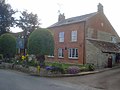
English: Ashleworth (sometimes formerly spelled ‘Ashelworth’) is a village and civil parish in the Tewkesbury district of Gloucestershire, England, with a population of 540 (United Kingdom Census 2011), about six miles north of Gloucester. It has two pubs, the Boat Inn and the Queens Arms. The oldest part of the village is Ashleworth Quay, on a flood plain on the west bank of the River Severn. (→Ashleworth)
Nederlands: Ashleworth is een plaats en civil parish in het Engelse graafschap Gloucestershire. (→Ashleworth)
Polski: Ashleworth – wieś w Anglii, w hrabstwie Gloucestershire, w dystrykcie Tewkesbury. Leży 7 km na północ od miasta Gloucester i 155 km na zachód od Londynu. (→Ashleworth)

Subcategories
This category has the following 7 subcategories, out of 7 total.
Media in category "Ashleworth"
The following 190 files are in this category, out of 190 total.
-
 Admiring the wildlife^ - geograph.org.uk - 5727330.jpg 4,896 × 3,264; 6.2 MB
-
 Apples on the ground at Wickridge Street - geograph.org.uk - 4740836.jpg 1,600 × 901; 765 KB
-
 Ashleworth - geograph.org.uk - 3095994.jpg 3,296 × 2,472; 1.9 MB
-

-
 Ashleworth Court and church - geograph.org.uk - 3095919.jpg 4,320 × 3,240; 2.85 MB
-
 Ashleworth Court and St Andrew and St Bartholomew - geograph.org.uk - 3498452.jpg 3,197 × 2,053; 1.06 MB
-
 Ashleworth Court pig farm - geograph.org.uk - 1418414.jpg 640 × 480; 78 KB
-
 Ashleworth Court, Ashleworth - geograph.org.uk - 4977901.jpg 1,600 × 1,032; 772 KB
-
 Ashleworth Ham - geograph.org.uk - 5727326.jpg 4,896 × 3,264; 6.38 MB
-
 Ashleworth Meadows - geograph.org.uk - 2371146.jpg 4,272 × 2,376; 7.78 MB
-
 Ashleworth Meadows - geograph.org.uk - 2373005.jpg 4,272 × 2,848; 4.5 MB
-
 Ashleworth Memorial Hall - geograph.org.uk - 940520.jpg 640 × 480; 81 KB
-
 Ashleworth Primary School - geograph.org.uk - 1418202.jpg 640 × 480; 78 KB
-
 Ashleworth Quay - geograph.org.uk - 3497625.jpg 3,346 × 2,328; 1.67 MB
-
 Ashleworth Tithe Barn - geograph.org.uk - 3497628.jpg 3,343 × 2,274; 1.22 MB
-
 Ashleworth Tithe Barn - geograph.org.uk - 3497629.jpg 3,456 × 2,592; 2.23 MB
-
 Ashleworth Tithe Barn - geograph.org.uk - 4977897.jpg 1,600 × 1,065; 550 KB
-
 Ashleworth tithe barn door - geograph.org.uk - 5727292.jpg 3,264 × 4,896; 5.51 MB
-
 Ashleworth village - geograph.org.uk - 1112780.jpg 640 × 480; 68 KB
-
 Ashleworth Village Cross - geograph.org.uk - 3498978.jpg 3,364 × 2,404; 1.65 MB
-
 Ashleworth village green - 1 - geograph.org.uk - 1418180.jpg 640 × 480; 57 KB
-
 Ashleworth village green - 2 - geograph.org.uk - 1418191.jpg 640 × 480; 93 KB
-
 Ashleworth village green - geograph.org.uk - 2367512.jpg 1,024 × 685; 615 KB
-
 Ashleworth village sign - geograph.org.uk - 1419895.jpg 640 × 480; 61 KB
-
 Ashleworth, Gloucestershire ... post office. (5636991535).jpg 3,243 × 2,462; 5.5 MB
-
 Ashleworth, The Boat - geograph.org.uk - 5627342.jpg 1,600 × 1,200; 577 KB
-

-
 Barn at Box Bush Farm, Ashleworth - geograph.org.uk - 4977807.jpg 1,600 × 1,065; 751 KB
-
 Barn at Box Bush Farm, Ashleworth - geograph.org.uk - 711155.jpg 640 × 480; 147 KB
-
 Barn conversion, Wickridge Street - geograph.org.uk - 940538.jpg 640 × 480; 160 KB
-
 Big firewood - geograph.org.uk - 5727283.jpg 4,896 × 3,264; 3.39 MB
-
 Birds at Ashleworth Ham - geograph.org.uk - 5727323.jpg 4,896 × 3,264; 6.51 MB
-
 Boat at the Boat Inn - geograph.org.uk - 5727300.jpg 3,264 × 4,896; 4.45 MB
-
 Boat Inn, Ashleworth Quay - geograph.org.uk - 4977815.jpg 1,600 × 1,065; 552 KB
-
 Boat Inn, Ashleworth Quay - geograph.org.uk - 4977820.jpg 1,600 × 1,065; 707 KB
-
 Boat Inn, Ashleworth Quay - geograph.org.uk - 4977823.jpg 1,257 × 1,128; 385 KB
-
 Boat Inn, Ashleworth Quay - geograph.org.uk - 4977876.jpg 1,600 × 1,065; 735 KB
-
 Boat Inn, Ashleworth Quay - geograph.org.uk - 4977881.jpg 1,600 × 1,065; 654 KB
-
 Boxbush Farm, Ashleworth - geograph.org.uk - 931813.jpg 640 × 426; 95 KB
-
 Bridleway and drain - geograph.org.uk - 2267939.jpg 1,024 × 768; 664 KB
-
 Bridleway down to the river - geograph.org.uk - 1397152.jpg 640 × 480; 97 KB
-
 Buildings near the Boat Inn - geograph.org.uk - 2373055.jpg 3,809 × 2,636; 5.43 MB
-
 Cemetery entrance - geograph.org.uk - 1418326.jpg 640 × 480; 107 KB
-
 Cemetery on Quay Lane, Ashleworth - geograph.org.uk - 4978216.jpg 1,600 × 1,065; 737 KB
-
 Church and Tithe Barn at Ashleworth - geograph.org.uk - 3906806.jpg 800 × 519; 84 KB
-
 Cottage in Ashleworth - geograph.org.uk - 931812.jpg 640 × 426; 77 KB
-
 Cottage in Asleworth - geograph.org.uk - 1418093.jpg 640 × 480; 65 KB
-
 Cottages at White End, Ashleworth - geograph.org.uk - 647373.jpg 640 × 460; 118 KB
-
 Cottages on a road junction at The Stream - geograph.org.uk - 939785.jpg 640 × 480; 132 KB
-
 Cow and calf near Ashleworth Court - geograph.org.uk - 1419888.jpg 640 × 480; 81 KB
-

-
 Dilapidated farm buildings at Wickridge Street - geograph.org.uk - 4740834.jpg 1,600 × 901; 671 KB
-
 Drainage ditch and flooded footpath, near Ashleworth - geograph.org.uk - 3039623.jpg 1,600 × 1,200; 736 KB
-
 Dutch barns and a line of poplars - geograph.org.uk - 711194.jpg 640 × 480; 136 KB
-
 Entrance to Berrow Farm - geograph.org.uk - 939788.jpg 640 × 480; 154 KB
-
 Entrance to Broadstreet Farm, and footpath, Ashleworth - geograph.org.uk - 3039726.jpg 1,600 × 1,200; 611 KB
-
 Entrance to Broadstreet Farm, Ashleworth - geograph.org.uk - 3095880.jpg 4,320 × 3,240; 2.88 MB
-
 Entrance to Sawyers Rise - geograph.org.uk - 1418087.jpg 640 × 480; 73 KB
-
 Entrance to Stonebow Farm off Ham Road - geograph.org.uk - 4977729.jpg 1,600 × 1,065; 762 KB
-
 Entrance to Stream Farm - geograph.org.uk - 940542.jpg 640 × 480; 138 KB
-
 Entrance to Woodpeckers Close - geograph.org.uk - 1418076.jpg 640 × 480; 100 KB
-
 Escape Route - geograph.org.uk - 1955765.jpg 1,024 × 768; 311 KB
-
 Field at Ashleworth - geograph.org.uk - 931806.jpg 640 × 426; 104 KB
-
 Flash Floods near Ashleworth Meadows - geograph.org.uk - 86437.jpg 640 × 479; 86 KB
-
 Flood gate, Ashleworth Quay - geograph.org.uk - 2371243.jpg 4,272 × 2,848; 5.34 MB
-

-
 Flooded field, Hasfield - geograph.org.uk - 3039443.jpg 1,600 × 1,200; 470 KB
-
 Flooded footpath near Ashleworth - geograph.org.uk - 3039657.jpg 1,600 × 1,200; 636 KB
-
 Footpath from Foscombe Hill - geograph.org.uk - 939716.jpg 640 × 450; 149 KB
-
 Footpath onto the Severn floodplain - geograph.org.uk - 2267963.jpg 1,024 × 768; 715 KB
-
 Footpath to Foscombe - geograph.org.uk - 4740838.jpg 1,600 × 901; 760 KB
-
 Footpath towards Foscombe - geograph.org.uk - 4740835.jpg 1,600 × 901; 774 KB
-
 Georgian Postbox, Ashleworth - geograph.org.uk - 4977772.jpg 1,065 × 1,600; 466 KB
-
 Grade II listed signpost, Ashleworth - geograph.org.uk - 711607.jpg 640 × 480; 134 KB
-
 Grand old signpost - geograph.org.uk - 2367527.jpg 1,024 × 768; 603 KB
-
 Ham Road 1 - geograph.org.uk - 2153315.jpg 800 × 600; 408 KB
-
 Ham Road 2 - geograph.org.uk - 2153317.jpg 800 × 600; 409 KB
-
 Ham Road near Colways Farm - geograph.org.uk - 4977727.jpg 1,600 × 1,073; 536 KB
-
 Ham Road towards Ashleworth - geograph.org.uk - 4977730.jpg 1,600 × 1,122; 595 KB
-
 Harper's Farm on Nup End Lane, Ashleworth - geograph.org.uk - 4977754.jpg 1,600 × 1,106; 675 KB
-
 Harvested field near Broadstreet Farm - geograph.org.uk - 2566248.jpg 600 × 800; 360 KB
-
 Hay meadow at Longridge Farm - geograph.org.uk - 1399218.jpg 640 × 480; 101 KB
-

-
 Interior, Ashleworth church - geograph.org.uk - 3039699.jpg 1,600 × 1,200; 401 KB
-
 Junction with Foscombe Lane - geograph.org.uk - 1418080.jpg 640 × 480; 92 KB
-
 Ladder stile into the churchyard, Ashleworth - geograph.org.uk - 3095916.jpg 3,240 × 4,320; 3.62 MB
-
 Lane at Longridge End - geograph.org.uk - 1403019.jpg 640 × 480; 109 KB
-
 Lane from the river towards tithe barn - geograph.org.uk - 962285.jpg 640 × 480; 151 KB
-
 Lane junction at Ashleworth - geograph.org.uk - 1418219.jpg 640 × 480; 74 KB
-
 Lane to Ashleworth - geograph.org.uk - 1417505.jpg 640 × 480; 67 KB
-
 Lane to Ashleworth Quay - geograph.org.uk - 3095934.jpg 4,320 × 3,240; 3.1 MB
-
 Lawn Road - geograph.org.uk - 2153302.jpg 640 × 480; 94 KB
-
 Lawn Road, Ashleworth - geograph.org.uk - 2153300.jpg 640 × 480; 101 KB
-
 Lime trees, Ashleworth - geograph.org.uk - 2373067.jpg 4,272 × 2,848; 5.13 MB
-
 Longridge Farm - geograph.org.uk - 1403012 (cropped).jpg 269 × 269; 20 KB
-
 Longridge Farm - geograph.org.uk - 1403012.jpg 640 × 480; 119 KB
-
 Lych Gate on Quay Lane, Ashleworth - geograph.org.uk - 4978215.jpg 1,600 × 1,065; 811 KB
-
 Meadow near Longridge Farm - geograph.org.uk - 1401591.jpg 640 × 480; 99 KB
-
 Memorial Hall, Ashleworth - geograph.org.uk - 4977767.jpg 1,600 × 1,065; 498 KB
-
 Memorial Hall, Ashleworth - geograph.org.uk - 4977776.jpg 1,600 × 1,065; 424 KB
-
 Millennium plaque, Ashleworth - geograph.org.uk - 940501.jpg 640 × 516; 163 KB
-
 Modern Dutch barns, Ashleworth - geograph.org.uk - 3039686.jpg 1,600 × 1,200; 484 KB
-
 No parking for elver fishers - geograph.org.uk - 711933.jpg 640 × 469; 131 KB
-
 Nup End Lane junction, Ashleworth - geograph.org.uk - 940524.jpg 640 × 480; 104 KB
-
 Nupend Lane approaching The Stream - geograph.org.uk - 2153307.jpg 800 × 600; 430 KB
-
 Old cider orchard - geograph.org.uk - 2566232.jpg 800 × 451; 303 KB
-
 Old cider orchard, 2016 - geograph.org.uk - 5159109.jpg 1,600 × 901; 752 KB
-
 Old road sign, Ashleworth - geograph.org.uk - 931583.jpg 426 × 640; 107 KB
-
 Outbuildings at the Boat Inn, Ashleworth Quay - geograph.org.uk - 4977887.jpg 1,600 × 1,065; 781 KB
-
 Overlooking Longridge End - geograph.org.uk - 1403034.jpg 640 × 480; 86 KB
-
 Overlooking Rectory Farm - geograph.org.uk - 1417967.jpg 640 × 480; 99 KB
-
 Path junction on Foscombe Hill - geograph.org.uk - 1417978.jpg 640 × 480; 123 KB
-
 Plaque on the seat outside the Boat Inn, Ashleworth - geograph.org.uk - 2373029.jpg 3,834 × 2,709; 6.72 MB
-
 Pollarded willows along a field boundary - geograph.org.uk - 2015707.jpg 640 × 480; 106 KB
-
 Polling day at Ashleworth - geograph.org.uk - 1418099.jpg 640 × 480; 63 KB
-
 Post Office, Ashleworth - geograph.org.uk - 4977769.jpg 1,600 × 1,065; 624 KB
-
 Post office, Ashleworth - geograph.org.uk - 940522.jpg 640 × 480; 112 KB
-
 Power Lines over Ashleworth Ham - geograph.org.uk - 86416.jpg 640 × 479; 42 KB
-
 Powerlines near Ashleworth Quay - geograph.org.uk - 2370941.jpg 2,676 × 3,219; 5.09 MB
-
 Public footpath it may be, but not today - geograph.org.uk - 3039609.jpg 1,600 × 1,200; 746 KB
-
 Public Footpath off Broad Street - geograph.org.uk - 4979189.jpg 1,600 × 1,065; 741 KB
-

-
 Queens Arms, Ashleworth - geograph.org.uk - 4977789.jpg 1,600 × 1,065; 592 KB
-
 Queens Arms, Ashleworth - geograph.org.uk - 4977792.jpg 1,065 × 1,600; 498 KB
-
 Recycling centre, Ashleworth - geograph.org.uk - 940526.jpg 640 × 480; 157 KB
-
 Red Bell Tobacco, enamel sign - geograph.org.uk - 711605.jpg 640 × 480; 199 KB
-

-
 Road junction and signpost, Ashleworth - geograph.org.uk - 3095941.jpg 4,320 × 3,240; 2.87 MB
-
 Road junction, Ashleworth - geograph.org.uk - 3095967.jpg 4,320 × 3,240; 2.79 MB
-
 Road junction, Ashleworth - geograph.org.uk - 931585.jpg 640 × 426; 91 KB
-
 Road scene at the edge of Ashleworth - geograph.org.uk - 3039730.jpg 1,600 × 1,200; 387 KB
-
 Road sign on Ham Road at White End - geograph.org.uk - 4977747.jpg 1,600 × 1,065; 631 KB
-
 Road to Ashleworth - geograph.org.uk - 931830.jpg 640 × 426; 68 KB
-
 Road to Ashleworth Quay - geograph.org.uk - 711161.jpg 640 × 480; 168 KB
-

-
 Rough grazing land - geograph.org.uk - 4740837.jpg 1,600 × 901; 768 KB
-
 Severn floodplain view - geograph.org.uk - 2267959.jpg 1,024 × 768; 661 KB
-
 Signpost - geograph.org.uk - 1067456.jpg 640 × 480; 80 KB
-
 Signpost and road junction, Ashleworth - geograph.org.uk - 3039674.jpg 1,600 × 1,200; 345 KB
-
 St Andrew and St Bartholomew, Ashleworth - geograph.org.uk - 3497643.jpg 3,182 × 2,256; 1.13 MB
-
 St Andrew and St Bartholomew, Ashleworth - geograph.org.uk - 3498486.jpg 3,349 × 2,442; 1.53 MB
-
 St Andrew and St Bartholomew, Ashleworth - geograph.org.uk - 3498531.jpg 3,456 × 2,592; 1.66 MB
-
 St Andrew and St Bartholomew, Ashleworth - geograph.org.uk - 3498551.jpg 3,456 × 2,592; 1.94 MB
-
 St Andrew ^ Bartholomew Church, Ashleworth - geograph.org.uk - 4977920.jpg 1,600 × 1,065; 627 KB
-
 St Andrew ^ Bartholomew Church, Ashleworth - geograph.org.uk - 4977922.jpg 1,065 × 1,600; 371 KB
-
 St Andrew ^ Bartholomew Church, Ashleworth - geograph.org.uk - 4977924.jpg 1,600 × 1,065; 446 KB
-
 St Andrew ^ Bartholomew Church, Ashleworth - geograph.org.uk - 4977928.jpg 1,600 × 1,065; 422 KB
-
 St Andrew ^ Bartholomew Church, Ashleworth - geograph.org.uk - 4978009.jpg 1,317 × 1,600; 764 KB
-
 St Andrew ^ Bartholomew Church, Ashleworth - geograph.org.uk - 4978017.jpg 946 × 1,600; 714 KB
-
 St Andrew ^ Bartholomew Church, Ashleworth - geograph.org.uk - 4978025.jpg 1,020 × 1,600; 583 KB
-
 St Andrew ^ Bartholomew Church, Ashleworth - geograph.org.uk - 4978028.jpg 1,140 × 1,600; 356 KB
-
 St Andrew ^ Bartholomew Church, Ashleworth - geograph.org.uk - 4978038.jpg 1,065 × 1,600; 266 KB
-
 St Andrew ^ Bartholomew Church, Ashleworth - geograph.org.uk - 4978048.jpg 1,100 × 1,600; 475 KB
-
 St Andrew ^ Bartholomew Church, Ashleworth - geograph.org.uk - 4978053.jpg 1,065 × 1,600; 560 KB
-
 St Andrew ^ Bartholomew Church, Ashleworth - geograph.org.uk - 4978211.jpg 1,600 × 1,065; 441 KB
-
 Stonebow Farm - geograph.org.uk - 2267950.jpg 1,024 × 768; 678 KB
-
 Stonebow Farm, Ashleworth - geograph.org.uk - 3095969.jpg 4,320 × 3,240; 3.09 MB
-
 Stream Farm near Ashleworth - geograph.org.uk - 4977750.jpg 1,600 × 1,065; 634 KB
-
 Stream Farm near Ashleworth - geograph.org.uk - 4977751.jpg 1,600 × 1,065; 545 KB
-
 Telehone Kiosk on Nup End Lane, Ashleworth - geograph.org.uk - 4977774.jpg 1,065 × 1,600; 948 KB
-
 The Boat Inn - geograph.org.uk - 3497623.jpg 3,361 × 2,221; 1.91 MB
-
 The Boat Inn at sunset - geograph.org.uk - 5357986.jpg 5,184 × 3,456; 6.32 MB
-
 The Boat Inn, Ashleworth Quay - geograph.org.uk - 2373016.jpg 4,272 × 2,848; 6.4 MB
-
 The Boat Inn, Ashleworth Quay - geograph.org.uk - 3095935.jpg 4,320 × 3,240; 2.74 MB
-
 The post office at Ashleworth, Gloucestershire. (2984733544).jpg 1,280 × 960; 206 KB
-
 The Queens Arms - geograph.org.uk - 1418165.jpg 640 × 480; 70 KB
-
 The Stream - geograph.org.uk - 2153311.jpg 800 × 600; 436 KB
-
 The Whitmore Way at Foscombe Hill - geograph.org.uk - 1417973.jpg 640 × 480; 117 KB
-
 Tithe Barn, Ashleworth - geograph.org.uk - 3095893.jpg 4,320 × 3,240; 2.7 MB
-
 To Wickridge Street from The Stream - geograph.org.uk - 940546.jpg 640 × 480; 124 KB
-
 Track by Longridge Farm - geograph.org.uk - 5159113.jpg 1,600 × 901; 791 KB
-
 Track to Colways Farm, Hasfield - geograph.org.uk - 3039390.jpg 1,600 × 1,200; 494 KB
-
 Track to Colways Farm, Hasfield - geograph.org.uk - 3095970.jpg 4,320 × 3,240; 2.94 MB
-
 Trailer in a field - geograph.org.uk - 1505052.jpg 640 × 426; 83 KB
-
 Trees on a distant hillside - geograph.org.uk - 5727315.jpg 3,353 × 2,235; 755 KB
-
 View across The Lawn - geograph.org.uk - 4740833.jpg 1,600 × 1,200; 959 KB
-
 View from Over Old Road - geograph.org.uk - 940579.jpg 640 × 480; 193 KB
-
 Village Cross, Ashleworth - geograph.org.uk - 3498970.jpg 3,263 × 2,468; 1.75 MB
-
 Village Cross, Ashleworth - geograph.org.uk - 4977796.jpg 1,065 × 1,600; 565 KB
-
 Water meadow near Longridge Farm - geograph.org.uk - 1399203.jpg 640 × 480; 91 KB
-
 Ye olde signpost at Ashleworth - geograph.org.uk - 775005.jpg 640 × 426; 75 KB
-
 Ashleworth Village Sign - geograph.org.uk - 86605.jpg 640 × 479; 164 KB
-
 Barrow Hill - geograph.org.uk - 85610.jpg 640 × 479; 108 KB
-
 Bridleway at Long Reach - 2 - geograph.org.uk - 1401691.jpg 640 × 480; 102 KB
-
 Bridleway to Longridge Farm - geograph.org.uk - 1401703.jpg 640 × 480; 109 KB
-
 Horse Hill - geograph.org.uk - 85628.jpg 640 × 479; 92 KB
-
 Orchard, Ashleworth - geograph.org.uk - 83628.jpg 640 × 479; 84 KB
-
 Stonebow Farm - geograph.org.uk - 85606.jpg 640 × 479; 160 KB
-
 Stream Farm - geograph.org.uk - 85907.jpg 640 × 479; 94 KB
-
 Tree lined road, Ashleworth - geograph.org.uk - 931586.jpg 426 × 640; 113 KB


.jpg)


.jpg)


.jpg)


