Category:Arkansas River in Colorado
Jump to navigation
Jump to search
English: Media related to the Arkansas River in Colorado, United States.
Subcategories
This category has the following 11 subcategories, out of 11 total.
A
B
- Browns Canyon National Monument (29 F)
F
G
- Granite Boat Chute (3 F)
H
P
R
U
- Upper Arkansas River (14 F)
Media in category "Arkansas River in Colorado"
The following 98 files are in this category, out of 98 total.
-
 "In My Day!" (18518488309).jpg 3,895 × 3,101; 6.28 MB
-
 Acquirement of water rights in the Arkansas Valley in Colorado (IA acquirementofwat140gree).pdf 716 × 1,243, 90 pages; 5.32 MB
-
-
 Arkansas River (Royal Gorge).jpg 1,680 × 2,520; 963 KB
-
 Arkansas River (Royal Gorge, west of Canon City, Colorado, USA) 1 (21065076159).jpg 2,000 × 3,008; 3.59 MB
-
 Arkansas River (Royal Gorge, west of Canon City, Colorado, USA) 2 (21259957151).jpg 3,008 × 2,000; 3.35 MB
-
 Arkansas River (Royal Gorge, west of Canon City, Colorado, USA) 3 (21063826520).jpg 3,008 × 2,000; 3.46 MB
-
 Arkansas River (Royal Gorge, west of Canon City, Colorado, USA) 4 (20629256574).jpg 3,008 × 2,000; 3.66 MB
-
 Arkansas River (Royal Gorge, west of Canon City, Colorado, USA) 5 (21065084229).jpg 3,008 × 2,000; 3.22 MB
-
 Arkansas River (Royal Gorge, west of Canon City, Colorado, USA) 6 (20629256184).jpg 3,008 × 2,000; 3.48 MB
-
 Arkansas River (Royal Gorge, west of Canon City, Colorado, USA) 7 (21065083519).jpg 3,008 × 2,000; 3.12 MB
-
 Arkansas River - Cotopaxi, Colorado.jpg 4,194 × 2,771; 5.42 MB
-
 Arkansas River and Sawatch Range, Colorado (14203752365).jpg 4,000 × 3,000; 2.79 MB
-
-
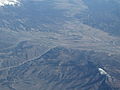
 Arkansas River Fowler CO aerial.jpg 2,507 × 1,185; 589 KB
-
 Arkansas River I50 CO.jpg 640 × 480; 115 KB
-
 Arkansas River in Colorado 2.jpg 12,968 × 3,834; 13.28 MB
-
 Arkansas River in Colorado.jpg 4,032 × 3,024; 2.77 MB
-
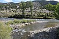
 Arkansas River Near Howard, Colorado (14017086058).jpg 4,000 × 3,000; 8.37 MB
-
 Arkansas River Near Salida, Colorado (14201260622).jpg 4,000 × 3,000; 10.46 MB
-
 Arkansas River Near Salida, Colorado (14203637514).jpg 4,000 × 3,000; 2.75 MB
-
 Arkansas river salida co.JPG 2,288 × 1,712; 818 KB
-
 Arkansas River Valley in Colorado.jpg 10,537 × 1,989; 3.81 MB
-
 Arkansas River Valley, Colorado (9181508878).jpg 3,000 × 4,000; 2.14 MB
-

-

-
 Arkansasriver.JPG 3,072 × 1,804; 1.17 MB
-
 Arkansasrivercanyon.JPG 4,320 × 3,240; 2.39 MB
-
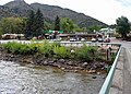
 ArkansasRiverwalk.jpg 2,740 × 1,772; 789 KB
-
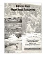 Arkansas River water needs assessment (IA arkansasriverwat00smit).pdf 633 × 822, 373 pages; 55.44 MB
-
 Beol river12.jpg 640 × 512; 29 KB
-
 Big Timbers.jpg 691 × 401; 153 KB
-
 Clear Creek - Headwaters to the Arkansas - panoramio.jpg 480 × 640; 219 KB
-
 Collegiate peaks pano large.jpg 4,073 × 990; 1.21 MB
-
 Colorado - Arkansas River (45318264014).jpg 7,952 × 5,304; 68.41 MB
-
 Colorado Arkansas River Rt 50 (30921732357).jpg 7,357 × 4,907; 50.35 MB
-
 Colorado Looking up the Arkansas Riv (45862440961).jpg 7,945 × 5,302; 51.16 MB
-
 Confluence of the Arkansas River and Fountain Creek.JPG 6,000 × 3,504; 11.97 MB
-
 Cotopaxi, Colorado.JPG 5,550 × 4,000; 18.27 MB
-
 East Fork Arkansas River.JPG 5,184 × 3,456; 11.15 MB
-
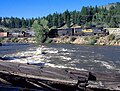
 Falls on the Arkansas. Colorado - NARA - 517513.jpg 3,000 × 1,627; 1.43 MB
-
 Gondola 2016-07-12 484.jpg 3,072 × 4,608; 1.7 MB
-
 Gorge of the Arkansas River 2016-07-12 476.jpg 3,072 × 4,608; 2.5 MB
-
 Gorge of the Arkansas River 2016-07-12 477.jpg 3,072 × 4,608; 2.69 MB
-
 Gorge of the Arkansas River 2016-07-12 485.jpg 3,072 × 4,608; 2.36 MB
-
 Gorge of the Arkansas River 2016-07-12 486.jpg 3,072 × 4,608; 2.21 MB
-
 Gorge of the Arkansas River 2016-07-12 487.jpg 3,072 × 4,608; 2.57 MB
-
 Gorge of the Arkansas River 2016-07-12 488.jpg 3,072 × 4,608; 2.17 MB
-
 Gorge of the Arkansas River 2016-07-12 503.jpg 3,072 × 4,608; 3.11 MB
-
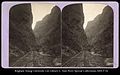
 Grand Canyon of the Arkansas, No. 2, D & R. G. Railway.jpg 2,145 × 1,317; 457 KB
-
 Granite colorado (4323216520).jpg 1,200 × 909; 793 KB
-
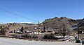 Granite, Colorado.JPG 5,134 × 2,791; 10.06 MB
-
 Grape Creek (Colorado).jpg 4,514 × 3,871; 14.16 MB
-
 Hanging Bridge 2016-07-12 502.jpg 3,072 × 4,608; 2.29 MB
-
 Hanging bridge through a canyon.jpg 2,146 × 1,334; 490 KB
-
 John Martin Reservoir CO.jpg 2,688 × 1,128; 610 KB
-
 Mount Harvard and the Valley of the Arkansas - NARA - 517702.jpg 3,000 × 2,282; 1.55 MB
-
 Mount Harvard, and view down Arkansas River. Colorado - NARA - 517512.jpg 3,000 × 1,829; 1.52 MB
-
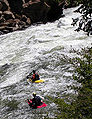
 Rafts 2361.jpg 4,032 × 3,024; 5.34 MB
-
 Royal Gorge (train).JPG 4,800 × 3,618; 16.61 MB
-
 Royal Gorge, Grand Canyon of the Arkansas (5711529024).jpg 1,452 × 2,000; 871 KB
-
-
 Santa Fe Trail - Arkansas River - NARA - 7721534.jpg 1,888 × 1,248; 601 KB
-
 Scouting -Big.jpg 1,855 × 2,405; 1.55 MB
-
 South Arkansas River mouth.JPG 5,868 × 3,907; 20.93 MB
-
 Sunset in Cañon City, CO - panoramio.jpg 3,888 × 2,592; 2.88 MB
-
 Tennessee Creek.JPG 3,817 × 3,233; 7.59 MB
-

-

-
 USACE John Martin Dam Arkansas River.jpg 1,500 × 1,000; 558 KB
-

-
-
 (Double?) Canon, from Robert N. Dennis collection of stereoscopic views.jpg 2,737 × 1,610; 1.71 MB
-
 (Double?) Canon, from Robert N. Dennis collection of stereoscopic views.png 2,737 × 1,610; 5.74 MB
-
 Across the chasm, from side canon, by Thurlow, J., 1831-1878.jpg 2,737 × 1,595; 1.68 MB
-
 Across the chasm, from side canon, by Thurlow, J., 1831-1878.png 2,737 × 1,595; 5.64 MB
-
 Below the Smelters, by Weitfle, Charles, 1836-1921.jpg 2,737 × 1,619; 1.62 MB
-
 Below the Smelters, by Weitfle, Charles, 1836-1921.png 2,737 × 1,619; 5.58 MB
-
 Devil's Punch Bowl falls, from Robert N. Dennis collection of stereoscopic views.jpg 2,737 × 1,598; 1.6 MB
-
 Devil's Punch Bowl falls, from Robert N. Dennis collection of stereoscopic views.png 2,737 × 1,598; 5.35 MB
-
 Double curve, by Weitfle, Charles, 1836-1921.jpg 2,737 × 1,634; 1.58 MB
-
 Double curve, by Weitfle, Charles, 1836-1921.png 2,737 × 1,634; 5.41 MB
-

-

-
 Exit of the Arkansas, Colorado, from Robert N. Dennis collection of stereoscopic views.jpg 2,737 × 1,597; 1.86 MB
-
 Exit of the Arkansas, Colorado, from Robert N. Dennis collection of stereoscopic views.png 2,737 × 1,597; 6.16 MB
-
 Railroad building, by Gurnsey, B. H. (Byron H.), 1833-1880 2.jpg 2,737 × 1,588; 1.65 MB
-
 Railroad building, by Gurnsey, B. H. (Byron H.), 1833-1880 2.png 2,737 × 1,588; 5.57 MB
-
 Railroad building, by Gurnsey, B. H. (Byron H.), 1833-1880.jpg 2,737 × 1,597; 1.64 MB
-
 Railroad building, by Gurnsey, B. H. (Byron H.), 1833-1880.png 2,737 × 1,597; 5.59 MB
-
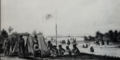
 View of men on the railroad, by Gurnsey, B. H. (Byron H.), 1833-1880.jpg 2,737 × 1,602; 1.62 MB
-
 View of men on the railroad, by Gurnsey, B. H. (Byron H.), 1833-1880.png 2,737 × 1,602; 5.51 MB
-
 View of men on the rocks, by C. W. Talbot.jpg 2,737 × 1,624; 1.5 MB
-
 View of men on the rocks, by C. W. Talbot.png 2,737 × 1,624; 5.15 MB
-
 View of the rocks, by Martin, Alexander, d. 1929.jpg 2,737 × 1,597; 1.53 MB
-
 View of the rocks, by Martin, Alexander, d. 1929.png 2,737 × 1,597; 5.25 MB
-
 Waterfall?, from Robert N. Dennis collection of stereoscopic views.jpg 2,737 × 1,604; 1.46 MB
-
 Waterfall?, from Robert N. Dennis collection of stereoscopic views.png 2,737 × 1,604; 4.98 MB
.jpg)
.jpg)
.jpg)
_1_(21065076159).jpg)
_2_(21259957151).jpg)
_3_(21063826520).jpg)
_4_(20629256574).jpg)
_5_(21065084229).jpg)
_6_(20629256184).jpg)
_7_(21065083519).jpg)

.jpg)
.jpg)


.jpg)
.jpg)
.jpg)

.jpg)
.jpg)


.jpg)
.jpg)
.jpg)


.jpg)

.jpg)


.JPG)
.jpg)


_Canon,_from_Robert_N._Dennis_collection_of_stereoscopic_views.jpg)
_Canon,_from_Robert_N._Dennis_collection_of_stereoscopic_views.png)


,_Col._Ter,_by_Chamberlain,_W._G._(William_Gunnison).jpg)
,_Col._Ter,_by_Chamberlain,_W._G._(William_Gunnison).png)


,_1833-1880_2.jpg)
,_1833-1880_2.png)
,_1833-1880.jpg)
,_1833-1880.png)
,_1833-1880.jpg)
,_1833-1880.png)


Categories:
- Arkansas River
- Rivers of Colorado
- Geography of Lake County, Colorado
- Geography of Chaffee County, Colorado
- Geography of Fremont County, Colorado
- Geography of Pueblo County, Colorado
- Geography of Crowley County, Colorado
- Geography of Otero County, Colorado
- Geography of Bent County, Colorado
- Geography of Prowers County, Colorado
- Locations along Interstate 25 in Colorado
- Locations along U.S. Route 24 in Colorado
- Locations along U.S. Route 50 in Colorado
- Locations along U.S. Route 87 in Colorado
- Locations along U.S. Route 285 in Colorado
- Locations along U.S. Route 400 in Colorado
- Locations along U.S. Route 50 Business (Pueblo–Avondale, Colorado)
- Locations along Colorado State Highway 45
- Locations along Colorado State Highway 67
- Locations along Colorado State Highway 71
- Locations along Colorado State Highway 89
- Locations along Colorado State Highway 96
- Locations along Colorado State Highway 109
- Locations along Colorado State Highway 115
- Locations along Colorado State Highway 120
- Locations along Colorado State Highway 167
- Locations along Colorado State Highway 194
- Locations along Colorado State Highway 207
- Locations along Colorado State Highway 209
- Locations along Colorado State Highway 227
- Locations along Colorado State Highway 231
- Locations along Colorado State Highway 233
- Locations along Colorado State Highway 266
- Locations along Colorado State Highway 291
- Locations along Colorado State Highway 300