Category:Arizona transition zone/Mogollon Rim flora distribution maps
Jump to navigation
Jump to search
Subcategories
This category has only the following subcategory.
Q
- Quercus gambelii range maps (2 F)
Media in category "Arizona transition zone/Mogollon Rim flora distribution maps"
The following 8 files are in this category, out of 8 total.
-
 Fremontodendron californicum range map.jpg 613 × 731; 154 KB
-
 Juniperus deppeana varieties range map 2.png 3,980 × 3,980; 266 KB
-
 Purshia mexicana range map.jpg 1,046 × 1,255; 394 KB
-
 Quercus gambelii range map 1.png 3,331 × 3,330; 138 KB
-
 Rhus ovata range map.png 1,830 × 2,351; 241 KB
-
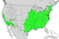 Salix nigra map.png 1,006 × 669; 193 KB
-
 Sambucus canadensis & Sambucus cerulea range map 1.png 7,980 × 7,979; 782 KB
-
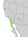
 Yucca elata range map.jpg 916 × 708; 206 KB


