Category:Archaeological site of Agios Andreas (Sifnos)
Jump to navigation
Jump to search
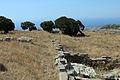
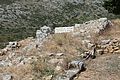
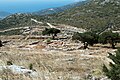
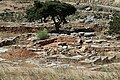
= Kastrou tou Ai Dria (or Agios Drias or Drios) on Sifnos, 427 meters above sea level
| Object location | | View all coordinates using: OpenStreetMap |
|---|
excavated prehistoric citadel on island of Siphnos  | |||||
| Upload media | |||||
| Instance of | |||||
|---|---|---|---|---|---|
| Location | Sifnos Municipality, Milos Regional Unit, South Aegean Region, Decentralized Administration of the Aegean, Greece | ||||
| Heritage designation |
| ||||
 | |||||
(Coordinates of the east entrance to the Archaeological site, near the church)
http://odysseus.culture.gr/h/3/eh355.jsp?obj_id=2404
Most of the findings here in the local Archaeological Museum near the western entrance to the complex (at the end of the new road, which leads all the way up).
Subcategories
This category has the following 2 subcategories, out of 2 total.
A
- Agios Andreas (Sifnos) (8 F)
Pages in category "Archaeological site of Agios Andreas (Sifnos)"
This category contains only the following page.
Media in category "Archaeological site of Agios Andreas (Sifnos)"
The following 40 files are in this category, out of 40 total.
-
 Archaeological site Ag. Andreas, Sifnos, 153568.jpg 5,384 × 3,589; 9.45 MB
-
 Archaeological site Ag. Andreas, Sifnos, 153574.jpg 5,174 × 3,449; 8.95 MB
-
 Archaeological site Ag. Andreas, Sifnos, 153577.jpg 5,472 × 3,648; 9.5 MB
-
 Archaeological site Ag. Andreas, Sifnos, 153579.jpg 5,472 × 3,648; 9.91 MB
-
 Archaeological site Ag. Andreas, Sifnos, 153580.jpg 5,472 × 3,648; 9.62 MB
-
 Archaeological site Ag. Andreas, Sifnos, 153589.jpg 5,472 × 3,648; 8.83 MB
-
 Archaeological site Ag. Andreas, Sifnos, 153595.jpg 5,472 × 3,648; 9.41 MB
-
 Archaeological site Ag. Andreas, Sifnos, cistern, 153581.jpg 5,472 × 3,648; 9.17 MB
-
 Archaeological site Ag. Andreas, Sifnos, cistern? 153590.jpg 5,472 × 3,648; 9.14 MB
-
 Archaeological site Ag. Andreas, Sifnos, eastern edge, 153598.jpg 4,579 × 3,053; 8.75 MB
-
 Archaeological site Ag. Andreas, Sifnos, surrounding of eastern entrance,153562.jpg 5,472 × 3,648; 9.63 MB
-
 Archaeological site Ag. Andreas, Sifnos, top of hill, 153585.jpg 5,472 × 3,648; 9.14 MB
-
 Archaeological site Ag. Andreas, Sifnos, western edge, 153578.jpg 5,472 × 3,648; 9.48 MB
-
 Eastern entrance to Archaeological site of Ag. Andreas, Sifnos, 153567.jpg 5,472 × 3,648; 9.66 MB
-
 Eastern entrance to Archaeological site of Ag. Andreas, Sifnos, 153569.jpg 5,313 × 3,542; 9.7 MB
-
 Gate I, Archaeological site Ag. Andreas, Sifnos, 153583.jpg 5,472 × 3,648; 9.56 MB
-
 Gate I, Archaeological site Ag. Andreas, Sifnos, 153584.jpg 5,472 × 3,648; 9.5 MB
-
 Gate II, Archaeological site Ag. Andreas, Sifnos, 153570.jpg 5,472 × 3,648; 9.4 MB
-
 Gate II, Archaeological site Ag. Andreas, Sifnos, 153575.jpg 5,472 × 3,648; 8.71 MB
-
 Gate II, Archaeological site Ag. Andreas, Sifnos, 153597.jpg 5,226 × 3,484; 9.86 MB
-

-
 Kastro of Sifnos from Ag. Andreas, 153607.jpg 5,472 × 3,648; 9.58 MB
-
 Landscape towards Platis Gialos on Sifnos, 153559.jpg 5,313 × 3,542; 8.58 MB
-
 Map of Archaeological site Ag. Andreas, Sifnos, 153566.jpg 5,231 × 3,487; 9.68 MB
-
 Mycenaean external wall, Archaeological site Ag. Andreas, Sifnos, 153561.jpg 5,472 × 3,648; 9.18 MB
-
 Mycenaean external wall, Archaeological site Ag. Andreas, Sifnos, 153563.jpg 5,472 × 3,648; 9.42 MB
-
 Sanctuary and Gate II, Archaeological site Ag. Andreas, Sifnos, 153586.jpg 5,472 × 3,648; 9.82 MB
-
 Sanctuary and Gate II, Archaeological site Ag. Andreas, Sifnos, 153588.jpg 5,472 × 3,648; 9.33 MB
-
 Sanctuary and Gate II, Archaeological site Ag. Andreas, Sifnos, 153591.jpg 5,472 × 3,648; 9.84 MB
-
 Sanctuary and Mycenaean wall, Archaeological site Ag. Andreas, Sifnos, 153593.jpg 5,472 × 3,648; 9.2 MB
-
 Sanctuary and Mycenaean wall, Archaeological site Ag. Andreas, Sifnos, 153596.jpg 5,472 × 3,648; 9.27 MB
-
 Sanctuary, Archaeological site Ag. Andreas, Sifnos, 153571.jpg 5,472 × 3,648; 9.21 MB
-
 Sanctuary, Archaeological site Ag. Andreas, Sifnos, 153572.jpg 5,472 × 3,648; 9.7 MB
-
 Sanctuary, Archaeological site Ag. Andreas, Sifnos, 153573.jpg 5,472 × 3,648; 9.44 MB
-
 Sanctuary, Archaeological site Ag. Andreas, Sifnos, 153587.jpg 5,472 × 3,648; 9.84 MB
-
 Sanctuary, Archaeological site Ag. Andreas, Sifnos, 153592.jpg 5,472 × 3,648; 9.56 MB
-
 Sanctuary, Archaeological site Ag. Andreas, Sifnos, 153594.jpg 5,472 × 3,648; 9.62 MB
-
 Southern part of the Mycenaean wall, Archaeological site Ag. Andreas, Sifnos, 153557.jpg 5,472 × 3,648; 8.6 MB
-
 Southern part of the Mycenaean wall, Archaeological site Ag. Andreas, Sifnos, 153558.jpg 5,472 × 3,648; 9.34 MB
-
 View from Ag. Andreas to Apollonia and Artemonas, Sifnos, 153599.jpg 5,472 × 3,648; 8.72 MB


