Category:Aqueduc de Luynes
Jump to navigation
Jump to search
| Object location | | View all coordinates using: OpenStreetMap |
|---|
|
This building is classé au titre des monuments historiques de la France. It is indexed in the base Mérimée, a database of architectural heritage maintained by the French Ministry of Culture, under the reference PA00097846
|
 | |||||
| Upload media | |||||
| Spoken text audio | |||||
|---|---|---|---|---|---|
| Instance of | |||||
| Location | Luynes, canton of Luynes | ||||
| Heritage designation |
| ||||
 | |||||
Pages in category "Aqueduc de Luynes"
This category contains only the following page.
Media in category "Aqueduc de Luynes"
The following 48 files are in this category, out of 48 total.
-
 Aquarelle aqueduc de Luynes - Gaignières.jpg 984 × 1,106; 340 KB
-
 Aqueduc cheval.png 718 × 567; 141 KB
-
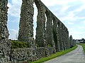
 Aqueduc de Luynes 1.jpg 1,417 × 1,207; 322 KB
-
 Aqueduc de Luynes 2.jpg 2,760 × 2,061; 326 KB
-
 Aqueduc de Luynes 3.jpg 1,417 × 1,026; 350 KB
-
 Aqueduc de Luynes 4.jpg 1,417 × 1,073; 292 KB
-
 Aqueduc Luynes amorce arc 2.jpg 1,440 × 1,920; 655 KB
-
 Aqueduc Luynes amorce arc.jpg 1,440 × 1,920; 310 KB
-
 Aqueduc Luynes arcades.jpg 1,920 × 1,440; 644 KB
-
 Aqueduc Luynes arche.jpg 1,920 × 1,440; 674 KB
-
 Aqueduc Luynes boulin.jpg 1,440 × 1,920; 677 KB
-
 Aqueduc Luynes composite.png 585 × 869; 1.18 MB
-
 Aqueduc Luynes E4.jpg 1,920 × 1,440; 635 KB
-
 Aqueduc Luynes ferme.jpg 1,920 × 1,440; 674 KB
-
 Aqueduc Luynes panorama.jpg 2,941 × 469; 629 KB
-
 Aqueduc Luynes penche.jpg 1,440 × 1,920; 684 KB
-
 Aqueduc Luynes pile carrée.jpg 1,440 × 1,920; 691 KB
-
 Aqueduc Luynes pile nord.jpg 1,440 × 1,920; 820 KB
-
 Aqueduc Luynes pile rect.jpg 1,440 × 1,920; 664 KB
-
 Aqueduc Luynes pile sud.jpg 1,440 × 1,920; 822 KB
-
 Aqueduc Luynes Sauvagère.jpg 1,054 × 165; 84 KB
-
 Aqueduc Luynes.jpg 4,248 × 2,548; 7.82 MB
-

-
 Aqueduc romain de Luynes - panoramio (1).jpg 4,352 × 2,448; 6.47 MB
-
 Aqueduc romain de Luynes - panoramio.jpg 4,352 × 2,448; 4.97 MB
-
 Aqueduct of Luynes 1 (37).jpg 3,872 × 2,592; 3.2 MB
-
 Aqueduct of Luynes 2 (37).jpg 3,872 × 2,592; 3.06 MB
-
 Aqueduct of Luynes 3 (37).jpg 3,872 × 2,592; 3.22 MB
-
 Carte aqueduc Luynes 13599.jpg 3,692 × 2,164; 6.78 MB
-
FR-Aqueduc de Luynes.ogg 37 min 42 s; 30.98 MB
-
 IMG 5737 - Luynes - Aqueduc romain - Partie centrale.jpg 5,660 × 3,184; 5 MB
-
 L'Aqueduc de Luynes.jpg 5,984 × 3,366; 7.45 MB
-
 Luynes (France) Roman Aqueduct.jpg 2,203 × 1,575; 1.18 MB
-
 Luynes (Indre-et-Loire) (9333105883).jpg 4,928 × 3,264; 6.3 MB
-
 Luynes (Indre-et-Loire) (9333113979).jpg 4,928 × 3,264; 5.89 MB
-
 Luynes (Indre-et-Loire) (9333572569).jpg 4,928 × 3,264; 10.03 MB
-
 Luynes (Indre-et-Loire) (9335917742).jpg 4,928 × 3,264; 9.28 MB
-
 Luynes (Indre-et-Loire) (9335926684).jpg 4,928 × 3,264; 6.43 MB
-
 Luynes (Indre-et-Loire) (9336184742).jpg 4,928 × 3,264; 10.99 MB
-
 Luynes aqueduc CP.jpg 1,583 × 1,008; 728 KB
-
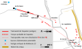 Luynes aqueduc itinéraire.svg 642 × 378; 80 KB
-
 Luynes Aqueduc Romain.jpg 2,048 × 1,536; 553 KB
-
 Luynes aqueduc tracé.png 642 × 378; 42 KB
-
 Luynes masse.svg 491 × 642; 102 KB
-
 Luynes plan masse.png 491 × 642; 62 KB
-
 Maillé Sauvagère.PNG 532 × 412; 261 KB
-
 Pile ressauts.png 302 × 582; 326 KB
-
 Römisches Aquaedukt bei Luynes, Frankreich.jpg 2,045 × 582; 242 KB


.jpg)

.jpg)
.jpg)
.jpg)


_Roman_Aqueduct.jpg)
_(9333105883).jpg)
_(9333113979).jpg)
_(9333572569).jpg)
_(9335917742).jpg)
_(9335926684).jpg)
_(9336184742).jpg)


