Category:Aqüeducte romà (Sant Jaume dels Domenys)
Jump to navigation
Jump to search
| Object location | | View all coordinates using: OpenStreetMap |
|---|
bridge in Sant Jaume dels Domenys, Spain _-_1.jpg) | |||||
| Upload media | |||||
| Instance of | |||||
|---|---|---|---|---|---|
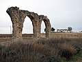
| Location | Sant Jaume dels Domenys, Baix Penedès, Tarragona Province, Catalonia | ||||
| Architectural style | |||||
| Heritage designation |
| ||||
 | |||||
Català: Aqüeducte romà. C. Menorca, Polígon Industrial els Arcs (Sant Jaume dels Domenys)
This is a category about a building indexed in the Catalan heritage register as Bé Cultural d'Interès Local (BCIL) under the reference IPA-5415. |
Media in category "Aqüeducte romà (Sant Jaume dels Domenys)"
The following 7 files are in this category, out of 7 total.
-
 211 Aqüeducte romà dels Arcs (Sant Jaume dels Domenys).JPG 2,816 × 1,584; 1.21 MB
-
 212 Aqüeducte romà dels Arcs (Sant Jaume dels Domenys).JPG 2,816 × 1,776; 1.28 MB
-
 213 Aqüeducte romà i masia dels Arcs (Sant Jaume dels Domenys).JPG 2,816 × 2,112; 1.59 MB
-
 215 Aqüeducte romà dels Arcs (Sant Jaume dels Domenys).JPG 2,816 × 1,832; 1.49 MB
-
 218 Aqüeducte romà dels Arcs (Sant Jaume dels Domenys).JPG 2,816 × 1,880; 1.57 MB
-
 219 Aqüeducte romà dels Arcs (Sant Jaume dels Domenys).JPG 2,816 × 2,112; 1.61 MB
-
 Aqüeducte romà (Sant Jaume dels Domenys) - 1.jpg 3,008 × 2,000; 3.31 MB
.JPG)
.JPG)
.JPG)
.JPG)
.JPG)
.JPG)