Category:Appleton-le-Street with Easthorpe
Jump to navigation
Jump to search
civil parish in the Ryedale district of North Yorkshire, England  | |||||
| Upload media | |||||
| Instance of | |||||
|---|---|---|---|---|---|
| Location | Ryedale, North Yorkshire, Yorkshire and the Humber, England | ||||
 | |||||
English: Appleton-le-Street with Easthorpe is a civil parish in the Ryedale district of North Yorkshire, England, consisting of Appleton-le-Street and Easthorpe. The parish had a population of 117 according to the 2001 census.
Subcategories
This category has only the following subcategory.
A
Media in category "Appleton-le-Street with Easthorpe"
The following 120 files are in this category, out of 120 total.
-
 A thistley field corner by Thackadale Lane - geograph.org.uk - 5525786.jpg 3,240 × 4,320; 2.73 MB
-
 All Saints' church, Appleton le Street - geograph.org.uk - 6315200.jpg 1,024 × 695; 89 KB
-
 Appleton Lane (Track) - geograph.org.uk - 3442342.jpg 4,000 × 3,000; 3.7 MB
-
 Appleton Lane - geograph.org.uk - 4734706.jpg 640 × 480; 96 KB
-
 Appleton Lane - geograph.org.uk - 5271027.jpg 2,592 × 1,936; 2.68 MB
-
 Appleton Lane - geograph.org.uk - 6163864.jpg 1,024 × 768; 168 KB
-
 Appleton Lane heading north - geograph.org.uk - 2453157.jpg 1,600 × 1,200; 533 KB
-

-

-
 Arable crop on the Howardian Hills - geograph.org.uk - 5525777.jpg 4,223 × 3,167; 2.81 MB
-
 Barn, Bog Hall - geograph.org.uk - 3639982.jpg 640 × 427; 272 KB
-
 Bog Hall - geograph.org.uk - 3635908.jpg 1,600 × 1,172; 1.93 MB
-
 Bog Hall - geograph.org.uk - 4082102.jpg 1,600 × 1,200; 415 KB
-
 Bog Hall - geograph.org.uk - 4350641.jpg 640 × 428; 91 KB
-
 Bog Hall Farm - geograph.org.uk - 4350644.jpg 640 × 428; 102 KB
-
 Bog Hall Farm behind field hedge - geograph.org.uk - 6117139.jpg 3,074 × 2,304; 3.69 MB
-
 Bridleway by Easthorpe Farm - geograph.org.uk - 5525780.jpg 4,320 × 3,240; 3.12 MB
-
 Bridleway near the Alamo Trekking Centre - geograph.org.uk - 2453651.jpg 1,600 × 1,200; 713 KB
-
 Bridleway to Appleton le Street - geograph.org.uk - 5924076.jpg 4,300 × 2,527; 1.69 MB
-
 Bright red berries of the Cuckoo pint - geograph.org.uk - 3635905.jpg 1,024 × 1,024; 1.35 MB
-
 Cyclist on Hepton Hill - geograph.org.uk - 3482266.jpg 640 × 427; 102 KB
-
 Edge of Nova Scotia - geograph.org.uk - 3635898.jpg 1,024 × 712; 753 KB
-
 Farm building off Thackadale Lane - geograph.org.uk - 2453649.jpg 1,600 × 1,200; 561 KB
-
 Farm buildings at Bog Hall Farm - geograph.org.uk - 6117149.jpg 4,608 × 3,456; 6.23 MB
-
 Farm track towards Easthorpe - geograph.org.uk - 2453138.jpg 1,600 × 1,200; 522 KB
-
 Farmland around Bog Hall - geograph.org.uk - 2757924.jpg 1,024 × 692; 189 KB
-
 Farmland near the Alamo Trekking Centre - geograph.org.uk - 2453653.jpg 1,600 × 1,200; 334 KB
-
 Farmland off Appleton Lane - geograph.org.uk - 2453162.jpg 1,600 × 1,200; 447 KB
-
 Farmland south of Appleton-le-Street - geograph.org.uk - 2453148.jpg 1,600 × 1,200; 315 KB
-
 Field boundary south of Appleton-le-Street - geograph.org.uk - 2453151.jpg 1,600 × 1,200; 372 KB
-
 Field edge off Appleton Lane - geograph.org.uk - 6163861.jpg 1,024 × 768; 261 KB
-
 Field edge track at Easthorpe - geograph.org.uk - 5924107.jpg 3,240 × 4,319; 4.1 MB
-
 Field Footpath to Amotherby - geograph.org.uk - 3442720.jpg 4,000 × 3,000; 2.44 MB
-
 Field Near Collier Hag Plantation - geograph.org.uk - 3639980.jpg 427 × 640; 300 KB
-
 Field near High Easthorpe - geograph.org.uk - 3640056.jpg 640 × 427; 271 KB
-
 Field track off Appleton Lane (Track) - geograph.org.uk - 3442372.jpg 4,000 × 3,000; 3.88 MB
-
 Field Track off Appleton Lane - geograph.org.uk - 3442695.jpg 4,000 × 3,000; 2.61 MB
-
 Fields Below Head Hag - geograph.org.uk - 3640027.jpg 640 × 427; 272 KB
-
 Fields near Highfield Farm - geograph.org.uk - 3497010.jpg 1,024 × 685; 318 KB
-
 Footpath between Bog Hall and Spring Wood - geograph.org.uk - 4082109.jpg 1,600 × 1,200; 693 KB
-
 Footpath-bridleway junction west of Spring Wood - geograph.org.uk - 4082115.jpg 1,600 × 1,200; 814 KB
-
 From Hepton Hill - geograph.org.uk - 3482264.jpg 640 × 427; 100 KB
-
 Gateway to Park House - geograph.org.uk - 2866127.jpg 640 × 427; 250 KB
-
 Hepton Hill - geograph.org.uk - 5916747.jpg 2,048 × 1,536; 1,006 KB
-
 High Easthorpe - geograph.org.uk - 3640051.jpg 640 × 427; 253 KB
-
 Horse gallops - geograph.org.uk - 2453143.jpg 1,600 × 1,200; 465 KB
-
 Horses at Easthorpe Hall - geograph.org.uk - 3482268.jpg 640 × 427; 89 KB
-
 Isolated, stone farm building - geograph.org.uk - 3499124.jpg 753 × 1,024; 387 KB
-
 Looking down the track called Appleton Lane - geograph.org.uk - 3444149.jpg 4,000 × 3,000; 3.18 MB
-
 Low Easthorpe Farm - geograph.org.uk - 4082131.jpg 1,600 × 1,200; 616 KB
-
 Minor road near Whitefield Farm - geograph.org.uk - 3496446.jpg 1,024 × 743; 257 KB
-
 Minor road, Appleton-le-Street - geograph.org.uk - 3499132.jpg 1,024 × 662; 281 KB
-
 Muddy Track near Bog Hall - geograph.org.uk - 4755013.jpg 3,024 × 4,032; 5.19 MB
-
 Near Appleton-le-Street - geograph.org.uk - 5271021.jpg 2,592 × 1,936; 1.2 MB
-
 Near Bog Hall - geograph.org.uk - 6085248.jpg 2,048 × 1,536; 1.09 MB
-
 Near The Alamo - geograph.org.uk - 5916745.jpg 2,048 × 1,536; 832 KB
-
 Northern slope of the Howardian Hills - geograph.org.uk - 5924085.jpg 4,320 × 3,240; 2.46 MB
-
 Occupation in 1831.png 849 × 473; 19 KB
-
 Oilseed rape crop, Appleton-le-Street - geograph.org.uk - 3499131.jpg 1,024 × 703; 400 KB
-
 Ordnance Survey Cut Mark with Bolt - geograph.org.uk - 4189193.jpg 4,000 × 3,000; 5.28 MB
-
 Outbuildings, Bog Hall - geograph.org.uk - 3635911.jpg 1,024 × 768; 928 KB
-
 Path at The Alamo - geograph.org.uk - 5916742.jpg 2,048 × 1,536; 1.28 MB
-
 Path near Appleton-le-Street - geograph.org.uk - 5916735.jpg 2,048 × 1,536; 1.02 MB
-
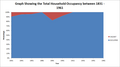 Percentage of Households Occupied.png 845 × 470; 17 KB
-
 Redbridge Sewer - geograph.org.uk - 6163853.jpg 1,024 × 768; 387 KB
-
 Redbridge Sewer from bridge on Appleton Lane - geograph.org.uk - 3442352.jpg 3,000 × 4,000; 4.34 MB
-
 Revamped Level Crossing Gatehouse - geograph.org.uk - 3442709.jpg 4,000 × 3,000; 2.88 MB
-
 South end of Amotherby Lane - geograph.org.uk - 4082215.jpg 1,600 × 1,200; 503 KB
-
 Spring le Howl - geograph.org.uk - 2609120.jpg 1,024 × 768; 245 KB
-
 Spring le Howl - geograph.org.uk - 2866124.jpg 640 × 427; 197 KB
-
 Start of footpath to Appleton-le-Street - geograph.org.uk - 2422536.jpg 1,024 × 768; 130 KB
-
 Thackadale Lane (track) heading south - geograph.org.uk - 2453647.jpg 1,600 × 1,200; 556 KB
-
 Thackadale Lane - geograph.org.uk - 2866130.jpg 640 × 427; 188 KB
-
 Thackadale Lane east of Low Easthorpe Farm - geograph.org.uk - 4082135.jpg 1,600 × 1,200; 700 KB
-
 The Alamo Trekking Centre - geograph.org.uk - 2866129.jpg 640 × 427; 190 KB
-
 The Alamo with the Mausoleum beyond - geograph.org.uk - 2805758.jpg 3,264 × 2,448; 1.6 MB
-
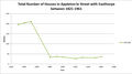 Total Number of Households.png 835 × 464; 17 KB
-
 Toward The Alamo and Spring Wood - geograph.org.uk - 2805789.jpg 3,264 × 2,448; 1.28 MB
-
 Track and Byway near Malton Grange - geograph.org.uk - 5880361.jpg 5,200 × 3,900; 3.05 MB
-
 Track from Bog Hall to Spring Wood - geograph.org.uk - 2095225.jpg 4,000 × 3,000; 3.33 MB
-
 Track leading to Bog Hall, near Castle Howard - geograph.org.uk - 3291002.jpg 1,024 × 768; 219 KB
-

-
 Track through the Wood - geograph.org.uk - 2805741.jpg 3,264 × 2,448; 2.65 MB
-
 Tree on the hillside - geograph.org.uk - 5924091.jpg 4,320 × 3,240; 2.02 MB
-

-

-

-

-
-

-

-

-

-

-

-

-

-
-
-

-

-

-

-

-

-

-

-

-

-

-

-

-

-

-

-

-

-

-

-
 Woodland Track to Easthorpe - geograph.org.uk - 2805770.jpg 3,264 × 2,448; 2.64 MB


_-_geograph.org.uk_-_3442342.jpg)


_-_geograph.org.uk_-_3442372.jpg)


_heading_south_-_geograph.org.uk_-_2453647.jpg)


