Category:Amthaus Aarau
Jump to navigation
Jump to search
| Object location | | View all coordinates using: OpenStreetMap |
|---|
building in Aarau in the canton of Aargau, Switzerland  | |||||
| Upload media | |||||
| Instance of | |||||
|---|---|---|---|---|---|
| Part of | |||||
| Location | Aarau, Aarau District, Aargau, Switzerland | ||||
| Street address |
| ||||
| Located on street |
| ||||
| Architectural style | |||||
| Architect | |||||
| Heritage designation | |||||
| Inception |
| ||||
 | |||||
Media in category "Amthaus Aarau"
The following 6 files are in this category, out of 6 total.
-
 Aarau Amthaus.jpg 2,000 × 1,500; 899 KB
-
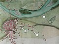 Aarau mit Telliring 1809.jpg 720 × 540; 117 KB
-
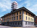
 Amthaus Aarau (2021).jpg 4,000 × 2,500; 6.23 MB
-
 Amthaus Aarau, Laurenzenvorstadt 12.jpg 4,000 × 2,893; 7.45 MB
-
 AmthausAarau01.jpg 1,879 × 1,440; 489 KB
-
 Kantonspolizei im Amthaus Aarau.jpg 3,780 × 4,200; 8.3 MB

.jpg)


