Category:Ammanford
Jump to navigation
Jump to search
town and community in Carmarthenshire, Wales   | |||||
| Upload media | |||||
| Instance of | |||||
|---|---|---|---|---|---|
| Location | Carmarthenshire, Wales | ||||
| Population |
| ||||
| Area |
| ||||
| official website | |||||
 | |||||
Subcategories
This category has the following 7 subcategories, out of 7 total.
A
- All Saints Church, Ammanford (5 F)
- Ammanford railway station (10 F)
C
- Capel Cymraeg Gwynfryn (2 F)
P
- Pontamman (3 F)
Media in category "Ammanford"
The following 200 files are in this category, out of 207 total.
(previous page) (next page)-
 0.43 acres development site in Ammanford - geograph.org.uk - 4344276.jpg 800 × 523; 115 KB
-
 20 along Bryn Mawr Avenue, Ammanford - geograph.org.uk - 4346537.jpg 800 × 561; 105 KB
-
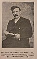 A young W. Nantlais Williams.jpg 1,148 × 1,804; 147 KB
-
 A-Z Convenience Store in Ammanford - geograph.org.uk - 4346516.jpg 800 × 469; 92 KB
-
 A474 descends to Ammanford - geograph.org.uk - 4673045.jpg 640 × 481; 47 KB
-
 A474 nears level crossing - geograph.org.uk - 4673046.jpg 640 × 480; 48 KB
-
 A474 reaches Pontamman - geograph.org.uk - 4673040.jpg 640 × 481; 55 KB
-
 Amma Stores, Ammanford - geograph.org.uk - 4346381.jpg 800 × 550; 100 KB
-
 Amman Valley Comprehensive School - geograph.org.uk - 20593.jpg 640 × 352; 136 KB
-

-
 Ammanford bus station entrance - geograph.org.uk - 4344695.jpg 800 × 548; 90 KB
-
 Ammanford Fish Bar - geograph.org.uk - 4344433.jpg 800 × 547; 106 KB
-
 Ammanford Park (Recreated) - geograph.org.uk - 299160.jpg 640 × 433; 69 KB
-
 Ammanford Park - geograph.org.uk - 20598.jpg 640 × 330; 114 KB
-
 Ammanford Post Office - geograph.org.uk - 5043173.jpg 1,024 × 747; 155 KB
-
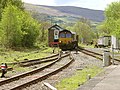
 Ammanford station - geograph.org.uk - 3075641.jpg 640 × 468; 141 KB
-
 Ammanford Tirydail Colliery geograph-2565800-by-Ben-Brooksbank.jpg 2,352 × 1,183; 482 KB
-
 Ammanford Town Hall - geograph.org.uk - 1447404.jpg 640 × 480; 72 KB
-
 Ammanford View - geograph.org.uk - 3791136.jpg 3,264 × 2,448; 2.07 MB
-
 Ammanford, Old Cross Inn - geograph.org.uk - 5043180.jpg 1,024 × 751; 147 KB
-
 Ammanford, Quay Street - geograph.org.uk - 5043168.jpg 1,024 × 768; 170 KB
-
 Ammanford, Quay Street.jpg 640 × 426; 88 KB
-
 Andi Pandi's Day Nursery in Ammanford - geograph.org.uk - 4346410.jpg 800 × 564; 112 KB
-
 Antur Insurance, Ammanford - geograph.org.uk - 4344245.jpg 800 × 722; 122 KB
-
 Arthur Street 20mph zone, Ammanford - geograph.org.uk - 4455697.jpg 800 × 741; 127 KB
-

-
 Bend in Tir y Dail Lane, Ammanford - geograph.org.uk - 4456626.jpg 800 × 644; 121 KB
-
 Betws, River Amman - geograph.org.uk - 5043178.jpg 1,024 × 768; 180 KB
-

-

-
 Bonllwyn Aquatic World near Ammanford - geograph.org.uk - 4457835.jpg 800 × 552; 127 KB
-
 Bonllwyn Green turned white - geograph.org.uk - 2208478.jpg 1,024 × 768; 112 KB
-
 Brynderwen Road, Ammanford - geograph.org.uk - 4345178.jpg 752 × 800; 136 KB
-
 Brynmawr Lane, Ammanford - geograph.org.uk - 4346669.jpg 800 × 557; 105 KB
-
 Brynmawr Lane, Ammanford - geograph.org.uk - 4346718.jpg 800 × 708; 177 KB
-

-
 Brynteg Terrace, Ammanford - geograph.org.uk - 4346658.jpg 800 × 563; 94 KB
-
 Canolfan Aman Centre - geograph.org.uk - 4412407.jpg 1,600 × 1,064; 299 KB
-
 Canolfan Aman Centre - geograph.org.uk - 4412417.jpg 1,600 × 1,064; 324 KB
-
 Carregaman Car Park, unused in the snow - geograph.org.uk - 2201038.jpg 1,024 × 768; 171 KB
-

-
 Coal delivery lorry in Ammanford - geograph.org.uk - 4456373.jpg 800 × 624; 104 KB
-
-
 Coffee roasting machine, The Roastery, Coaltown Coffee, Ammanford, Wales.jpg 3,024 × 4,032; 3.3 MB
-
 College Street - geograph.org.uk - 2936656.jpg 640 × 481; 60 KB
-

-
 Country lane - geograph.org.uk - 5776976.jpg 2,448 × 3,264; 2.73 MB
-
 Cwmllwchwr Mill, Ammanford - geograph.org.uk - 4440691.jpg 800 × 578; 152 KB
-
 David Jones Car Sales, Ammanford - geograph.org.uk - 4455761.jpg 800 × 436; 72 KB
-

-
 Departure from Ammanford railway station - geograph.org.uk - 4440697.jpg 800 × 481; 105 KB
-
 Derelict Bridge over Loughor - geograph.org.uk - 282307.jpg 640 × 480; 130 KB
-
 Detail of Twrch Trwyth sculpture - geograph.org.uk - 915217.jpg 640 × 480; 92 KB
-
 Disused rail bridge over the River Loughor - geograph.org.uk - 2975532.jpg 1,400 × 800; 216 KB
-

-

-
 East side of Tir y Dail Lane, Ammanford - geograph.org.uk - 4456447.jpg 800 × 671; 112 KB
-
 Eirllin, Ammanford - geograph.org.uk - 4344357.jpg 800 × 643; 120 KB
-
 Entrance to Ammanford railway station - geograph.org.uk - 4345189.jpg 800 × 643; 111 KB
-
 Entrance to Heol Wallasey - geograph.org.uk - 1153009.jpg 640 × 480; 67 KB
-
 Entrance to Marc's Motors in Ammanford - geograph.org.uk - 4346415.jpg 800 × 726; 138 KB
-
 Ffordd Wernoleu - geograph.org.uk - 1670808.jpg 2,048 × 1,536; 605 KB
-
 Flowery roundabout in Ammanford - geograph.org.uk - 4456553.jpg 800 × 525; 89 KB
-
 Footbridge and weir - geograph.org.uk - 1740361.jpg 2,048 × 1,536; 720 KB
-

-
 Former Ammanford Magistrates' Court - geograph.org.uk - 4344666.jpg 800 × 572; 106 KB
-

-
 Former VOSA Test Station, Ammanford - geograph.org.uk - 4456481.jpg 800 × 395; 62 KB
-
 Former VOSA Test Station, Ammanford - geograph.org.uk - 4456523.jpg 800 × 405; 81 KB
-
 Fresh Bites in Ammanford - geograph.org.uk - 4344626.jpg 800 × 429; 76 KB
-
 Gary Jones, Ammanford - geograph.org.uk - 4344293.jpg 796 × 800; 136 KB
-
 Gateway to Ammanford - geograph.org.uk - 915214.jpg 640 × 480; 96 KB
-
 Gosen Chapel, Llandybie - geograph.org.uk - 421326.jpg 640 × 427; 75 KB
-
 Gosen Chapel,Llandybie - geograph.org.uk - 421245.jpg 640 × 427; 54 KB
-
 Great Western, Ammanford - geograph.org.uk - 4345170.jpg 800 × 597; 115 KB
-

-
 Harold Street houses in Ammanford - geograph.org.uk - 4346427.jpg 800 × 631; 124 KB
-
 Harold Street, Ammanford - geograph.org.uk - 4346417.jpg 800 × 558; 127 KB
-
 Head Candy - geograph.org.uk - 5751928.jpg 3,264 × 2,448; 2.72 MB
-
 Head Candy, Ammanford - geograph.org.uk - 4455721.jpg 800 × 564; 104 KB
-
 Headworks in Ammanford - geograph.org.uk - 4344678.jpg 800 × 719; 134 KB
-

-

-

-

-

-
 Iced weir on River Amman - geograph.org.uk - 2209663.jpg 1,536 × 1,152; 310 KB
-

-

-

-
 Iscennen Road bench, Ammanford - geograph.org.uk - 4456571.jpg 800 × 632; 139 KB
-
 Iscennen Road, Ammanford - geograph.org.uk - 4344227.jpg 800 × 629; 92 KB
-
 Iscennen Road, Ammanford - geograph.org.uk - 4456578.jpg 800 × 628; 115 KB
-
 ISmooth and Mencap in Ammanford - geograph.org.uk - 4344399.jpg 800 × 698; 135 KB
-

-
 John Francis estate agents in Ammanford - geograph.org.uk - 4344305.jpg 789 × 800; 142 KB
-

-

-
 Ling Di Long in Ammanford - geograph.org.uk - 4344262.jpg 800 × 576; 100 KB
-

-
 Llys Cennen Solicitors Ammanford Office - geograph.org.uk - 4344216.jpg 800 × 596; 111 KB
-

-
 Maheen's in Ammanford - geograph.org.uk - 4344337.jpg 800 × 637; 107 KB
-
 Margaret Street Pharmacy, Ammanford - geograph.org.uk - 4344196.jpg 800 × 521; 102 KB
-
 May Day pink blossom in Ammanford - geograph.org.uk - 4457940.jpg 800 × 593; 130 KB
-
 Memorial plaque to Nantlais, in Bethany Chapel.jpg 4,032 × 3,024; 2.52 MB
-
 Mill Units, Station Road, Ammanford - geograph.org.uk - 4354982.jpg 800 × 444; 78 KB
-
 Miners' Memorial, Ammanford - geograph.org.uk - 270444.jpg 480 × 640; 74 KB
-
 Miners' Welfare Club, Rhydaman-Ammanford - geograph.org.uk - 273620.jpg 640 × 518; 131 KB
-
 Myddynfych 20mph zone, Ammanford - geograph.org.uk - 4457887.jpg 800 × 490; 89 KB
-
 Myddynfych, Ammanford - geograph.org.uk - 4457900.jpg 800 × 482; 90 KB
-
 M^N Catering Ammanford - geograph.org.uk - 4440267.jpg 800 × 525; 108 KB
-
 Nantlais, Ammanford - geograph.org.uk - 4457974.jpg 640 × 468; 90 KB
-
 New Chopstick House in Ammanford - geograph.org.uk - 4344422.jpg 800 × 739; 139 KB
-
 NNW along Bryn Mawr Avenue, Ammanford - geograph.org.uk - 4346713.jpg 800 × 600; 157 KB
-

-

-
 Old railway line Pontamman - geograph.org.uk - 875665.jpg 480 × 640; 120 KB
-
 Old Road, Ammanford - geograph.org.uk - 4457999.jpg 800 × 687; 129 KB
-

-
 Ordnance Survey Cut Mark - geograph.org.uk - 3519309.jpg 480 × 640; 116 KB
-
 Ordnance Survey Cut Mark - geograph.org.uk - 3519314.jpg 480 × 640; 107 KB
-
 Ordnance Survey Cut Mark - geograph.org.uk - 3519370.jpg 480 × 640; 123 KB
-
 Ordnance Survey Cut Mark - geograph.org.uk - 3519385.jpg 480 × 640; 125 KB
-
 Ordnance Survey Cut Mark - geograph.org.uk - 3519400.jpg 480 × 640; 107 KB
-
 Ordnance Survey Cut Mark - geograph.org.uk - 3552772.jpg 480 × 640; 78 KB
-
 Ordnance Survey Cut Mark - geograph.org.uk - 3564306.jpg 480 × 640; 83 KB
-
 Ordnance Survey Cut Mark - geograph.org.uk - 3573383.jpg 480 × 640; 61 KB
-
 Ordnance Survey Cut Mark - geograph.org.uk - 3617388.jpg 480 × 640; 101 KB
-
 Ordnance Survey Pivot - geograph.org.uk - 3617383.jpg 640 × 480; 44 KB
-
 Pantyffynnon station - geograph.org.uk - 5845187.jpg 5,184 × 3,888; 4.92 MB
-

-

-
 Penybanc Road - geograph.org.uk - 2936662.jpg 640 × 481; 76 KB
-
 Pink house in Ammanford - geograph.org.uk - 4346684.jpg 800 × 502; 109 KB
-
 Pompren Afon Llwchwr Footbridge - geograph.org.uk - 4163346.jpg 640 × 480; 122 KB
-
 Pontaman Road - geograph.org.uk - 5776987.jpg 3,264 × 2,448; 3.19 MB
-
 Quay Street, Ammanford (Recreated) - geograph.org.uk - 299161.jpg 640 × 451; 86 KB
-
 Quay Street, Ammanford in the snow - geograph.org.uk - 2201017.jpg 1,536 × 1,152; 206 KB
-

-
 Railway bridge over the River Amman in Pontamman - geograph.org.uk - 5845251.jpg 3,888 × 5,184; 6.16 MB
-
 Recreation Ground - geograph.org.uk - 5751933.jpg 3,264 × 2,448; 2.02 MB
-

-
 Recycling centre - geograph.org.uk - 1740367.jpg 2,048 × 1,536; 612 KB
-
 Red Kite - geograph.org.uk - 5776966.jpg 2,071 × 1,701; 874 KB
-

-
 Removing old tip at Pontamman - geograph.org.uk - 876144.jpg 640 × 480; 90 KB
-
 River Amman after snowfall - geograph.org.uk - 2201080.jpg 1,152 × 864; 188 KB
-
 River Loughor west of the A483, Bonllwyn - geograph.org.uk - 4457790.jpg 800 × 588; 216 KB
-

-
 Ruined walls at former Pont-y-Clerc Colliery - geograph.org.uk - 2975524.jpg 1,024 × 768; 221 KB
-
 Section of Pantyffynnon to Ammanford cycle path - geograph.org.uk - 3584241.jpg 768 × 1,024; 189 KB
-
 Sheets of ice on the River Amman - geograph.org.uk - 2209666.jpg 1,152 × 864; 145 KB
-

-
 Signal box at Pantyffynnon - geograph.org.uk - 5515793.jpg 1,024 × 768; 250 KB
-

-
 Snowy view up the River Amman - geograph.org.uk - 2201093.jpg 1,536 × 1,152; 285 KB
-

-

-
 Southern end of Shands Road, Ammanford - geograph.org.uk - 4440296.jpg 800 × 543; 103 KB
-
 Splash pads - panoramio.jpg 1,176 × 732; 269 KB
-
 St Michael's Church, Ammanford - geograph.org.uk - 1447403.jpg 640 × 480; 56 KB
-
 Station Road car wash, Ammanford - geograph.org.uk - 4346433.jpg 800 × 568; 104 KB
-
 Station Road level crossing, Ammanford - geograph.org.uk - 4483656.jpg 800 × 600; 137 KB
-
 Stop sign at Ammanford railway station - geograph.org.uk - 4440702.jpg 800 × 609; 158 KB
-
 Sundog - Parhelia - geograph.org.uk - 496633.jpg 640 × 480; 26 KB
-
 Sunrise from Heol Ddu - geograph.org.uk - 749403.jpg 481 × 640; 51 KB
-
 SW end of Iscennen Road, Ammanford - geograph.org.uk - 4456607.jpg 800 × 554; 96 KB
-
 Swn-y-Gwynt Resource Centre, Ammanford - geograph.org.uk - 4456343.jpg 800 × 571; 148 KB
-
 T K Beynon, Ammanford - geograph.org.uk - 4455673.jpg 800 × 516; 81 KB
-
 Talbot Road, Ammanford - geograph.org.uk - 4455781.jpg 800 × 596; 86 KB
-
 Tegfan Residential Home, Ammanford - geograph.org.uk - 4455728.jpg 800 × 618; 151 KB
-
 The Arcade, Ammanford - geograph.org.uk - 4360352.jpg 1,600 × 958; 308 KB
-
 The Co-operative Food Store in Ammanford - geograph.org.uk - 4344651.jpg 800 × 613; 110 KB
-
 The first Bethany Chapel, opened in May 1881.jpg 1,801 × 2,048; 152 KB
-
 The New Betws Mine road "Today" - geograph.org.uk - 953012.jpg 640 × 480; 62 KB
-

-

-
 Tir y Dail Lane houses, Ammanford - geograph.org.uk - 4456323.jpg 800 × 629; 85 KB
-

-

-

-
 Train on the bridge - geograph.org.uk - 823458.jpg 640 × 423; 88 KB
-

-
 Upstream along the Loughor, Bonllwyn - geograph.org.uk - 4457796.jpg 800 × 622; 209 KB
-
 View of the Amman river bank - geograph.org.uk - 368423.jpg 640 × 480; 95 KB
-
 Wales Carmarthenshire Community Ammanford map.svg 512 × 399; 1.12 MB
-

-
 Welcome to Ammanford - geograph.org.uk - 2978042.jpg 640 × 480; 131 KB
-
 Welcome to Ammanford sign - geograph.org.uk - 4457870.jpg 640 × 520; 83 KB
-
 West across Dyffryn Bridge, Ammanford - geograph.org.uk - 4398773.jpg 800 × 600; 156 KB
-
 West along Florence Road, Ammanford - geograph.org.uk - 4455674.jpg 800 × 593; 90 KB
-

-
 Work in progress, Pantyffynnon railway station - geograph.org.uk - 5515801.jpg 893 × 1,024; 203 KB
-

-

-
 Ysgol Dyffryn Aman.jpg 4,080 × 3,072; 4.37 MB
-
 Ammanford Cemetery - geograph.org.uk - 19775.jpg 640 × 392; 74 KB
-
 Cleared plots - geograph.org.uk - 391861.jpg 640 × 485; 98 KB
-
 Derelict Railway Bridge - geograph.org.uk - 282300.jpg 640 × 480; 127 KB


_-_geograph.org.uk_-_299160.jpg)


,_Carmarthenshire_-_geograph.org.uk_-_3996637.jpg)


_-_geograph.org.uk_-_299161.jpg)


