Category:Am Plan 10, Pirna
Jump to navigation
Jump to search

| Object location | | View all coordinates using: OpenStreetMap |
|---|
| (Wikidata) |
| Upload media | |||||
| Instance of | |||||
|---|---|---|---|---|---|
| Location | Pirna, Sächsische Schweiz-Osterzgebirge, Saxony, Germany | ||||
| Heritage designation | |||||
 | |||||
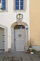
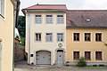
Deutsch: Wohnhaus, Eckhaus, bezeichnet 1776 (Wohnhaus); baugeschichtlich und städtebaulich von Bedeutung, schönes barockes Korbbogenportal mit Kartusche
Media in category "Am Plan 10, Pirna"
The following 13 files are in this category, out of 13 total.
-
 2022032101 Korbbogenportal Am Plan 10 Kartusche mit Jahreszahl1776 2022.jpg 4,000 × 6,016; 10.79 MB
-
 2022032102 Kartusche Jahreszahl 1776 korbbogenportal Am Plan 10 2022.jpg 5,184 × 3,456; 7.83 MB
-
 Am Plan 10 Pirna.JPG 1,920 × 2,560; 2.13 MB
-
 Am Plan 10.jpg 6,016 × 4,000; 10.12 MB
-
 Am Plan Pirna 118848817.jpg 5,184 × 3,888; 8.24 MB
-
 Am Plan Pirna 118848821.jpg 3,888 × 5,184; 9.01 MB
-
 Am Plan Pirna 118848900.jpg 5,184 × 3,888; 9.6 MB
-
 Am Plan Pirna 118849415.jpg 5,184 × 3,888; 8.38 MB
-
 Pirna, Am Plan 10, 01.jpg 3,445 × 5,003; 3.13 MB
-
 Planwinkel Pirna 118848776.jpg 5,184 × 3,888; 8.66 MB
-
 Planwinkel Pirna 118848779.jpg 3,888 × 5,184; 8.82 MB
-
 Planwinkel Pirna 118848791.jpg 3,888 × 5,184; 8.66 MB
-
 Planwinkel Pirna 118848795.jpg 3,888 × 5,184; 8.05 MB


