Category:Altes Schloss Ettmannsdorf
Jump to navigation
Jump to search
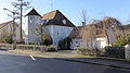
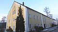
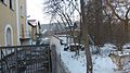
This is the category of the Bavarian Baudenkmal (cultural heritage monument) with the ID D-3-76-161-36 (Wikidata)
|
| Object location | | View all coordinates using: OpenStreetMap |
|---|
 | |||||
| Upload media | |||||
| Instance of | |||||
|---|---|---|---|---|---|
| Location | Schwandorf, Upper Palatinate, Bavaria, Germany | ||||
| Street address |
| ||||
| Heritage designation | |||||
 | |||||
Media in category "Altes Schloss Ettmannsdorf"
The following 6 files are in this category, out of 6 total.
-
 Altes Schloss Ettmannsdorf-1.JPG 4,896 × 2,752; 5.64 MB
-
 Altes Schloss Ettmannsdorf-2.JPG 4,896 × 2,752; 5.61 MB
-
 Altes Schloss Ettmannsdorf.JPG 4,896 × 2,752; 5.91 MB
-
 Ettmannsdorf-1.jpg 4,896 × 2,752; 1.11 MB
-
 Ettmannsdorf-4.jpg 4,896 × 2,752; 1.81 MB
-
 Hammerschloss-in-ettmannsdorf.jpg 1,200 × 867; 278 KB


