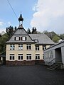
Category:Alte Schule Niederreifenberg
Jump to navigation
Jump to search
| Object location | | View all coordinates using: OpenStreetMap |
|---|
This is the category of the Hessian Kulturdenkmal (cultural monument) with the ID 100381 (Wikidata)
|
| Upload media | |||||
| Instance of | |||||
|---|---|---|---|---|---|
| Location | Schmitten im Taunus, Hochtaunuskreis, Darmstadt Government Region, Hesse, Germany | ||||
| Heritage designation | |||||
 | |||||
Media in category "Alte Schule Niederreifenberg"
The following 6 files are in this category, out of 6 total.
-
 2014-05-04 14.51.37 neu.jpg 1,024 × 768; 179 KB
-
 2014-05-04 14.54.42 neu.jpg 1,024 × 768; 192 KB
-
 2014-05-04 14.55.27 neu.jpg 768 × 1,024; 183 KB
-
 2014-05-04 14.55.55 neu.jpg 1,024 × 768; 149 KB
-
 2014-05-04 15.20.48 neu.jpg 768 × 1,024; 208 KB
-
 Alte Schule Niederreifenberg.jpg 1,712 × 2,288; 294 KB


