Category:Algemene begraafplaats Surhuisterveen
Jump to navigation
Jump to search
| Object location | | View all coordinates using: OpenStreetMap |
|---|
 | |||||
| Upload media | |||||
| Instance of |
| ||||
|---|---|---|---|---|---|
| Part of | |||||
| Location | Surhuisterveen, Achtkarspelen, Friesland, Netherlands | ||||
| Heritage designation |
| ||||
 | |||||
|
This is a category about rijksmonumentcomplex number 502025
|
|
This is a category about rijksmonument number 502034
|
| Address |
|
Subcategories
This category has only the following subcategory.
L
- Lijkenhuisje, Surhuisterveen (16 F)
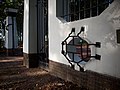
Media in category "Algemene begraafplaats Surhuisterveen"
The following 9 files are in this category, out of 9 total.
-
 Algemene begraafplaats, toegangshek.jpg 3,264 × 2,448; 1.48 MB
-
 Toegangshek, Vierhuisterweg 32, Surhuisterveen.JPG 4,608 × 3,456; 3.1 MB
-
 Toegangspoort 1.jpg 4,032 × 3,024; 993 KB
-
 Toegangspoort 2.jpg 4,032 × 3,024; 1.35 MB
-
 Toegangspoort 3.jpg 3,948 × 2,961; 967 KB
-
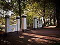 Toegangspoort 4.jpg 4,032 × 3,024; 2.01 MB
-
 Toegangspoort 5.jpg 2,849 × 3,798; 1.48 MB
-
 Wik 067.JPG 3,888 × 2,592; 5.05 MB
-
 Wik 28-092010 038.JPG 3,888 × 2,592; 5.51 MB


