Category:Ajuntament de Calafell
Jump to navigation
Jump to search
| Object location | | View all coordinates using: OpenStreetMap |
|---|
  | |||||
| Upload media | |||||
| Instance of | |||||
|---|---|---|---|---|---|
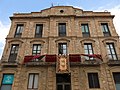
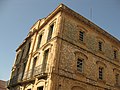
| Location | Calafell, Baix Penedès, Tarragona Province, Catalonia | ||||
| Architectural style | |||||
| Heritage designation |
| ||||
 | |||||
Català: Ajuntament (Calafell)
This is a category about a building indexed in the Catalan heritage register as Bé Cultural d'Interès Local (BCIL) under the reference IPA-5326. |
Media in category "Ajuntament de Calafell"
The following 3 files are in this category, out of 3 total.
-
 002 Ajuntament de Calafell, pl. Catalunya 1, des del c. Bisbe Català.jpg 2,816 × 2,112; 2.37 MB
-
 044 Ajuntament.jpg 2,272 × 1,704; 1.22 MB
-
 049 Ajuntament (Calafell).jpg 2,272 × 1,704; 1.33 MB

.jpg)