Category:Agricultural maps of Germany
Jump to navigation
Jump to search
Media in category "Agricultural maps of Germany"
The following 7 files are in this category, out of 7 total.
-
 Obstbau-Karte des Herzogtums Sachsen-Altenburg 1901.jpg 3,507 × 2,480; 4.28 MB
-
 305 of 'The International Geography. ... Edited by H. R. Mill' (11289264126).jpg 1,400 × 1,291; 522 KB
-
 56 of Longmans' Junior School Geography, etc. (11214144254).jpg 2,704 × 2,001; 1.75 MB
-
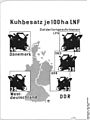 Bundesarchiv Bild 183-72203-0001, Infografik Kuhbestand.jpg 599 × 800; 59 KB
-
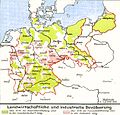 Lange diercke sachsen deutschland landwirtschaftliche und industrielle bevoelkerung.jpg 1,262 × 1,213; 534 KB
-
 Saksamaa veinipiirkonnad.jpg 1,300 × 1,200; 153 KB
-
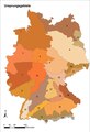 Ursprungsgebiete.tif 2,203 × 3,230; 20.36 MB

.jpg)
.jpg)


