Category:Aerial photographs of Northumberland
Jump to navigation
Jump to search
Ceremonial counties of England: Bedfordshire · Berkshire · Buckinghamshire · Cambridgeshire · Cheshire · Cornwall · Cumbria · Derbyshire · Devon · Dorset · Durham · East Riding of Yorkshire · East Sussex · Essex · Gloucestershire · Greater London · Greater Manchester · Hampshire · Herefordshire · Hertfordshire · Isle of Wight · Kent · Lancashire · Leicestershire · Lincolnshire · Merseyside · Norfolk · North Yorkshire · Northamptonshire · Northumberland · Nottinghamshire · Oxfordshire · Shropshire · Somerset · South Yorkshire · Staffordshire · Suffolk · Surrey · Tyne and Wear · Warwickshire · West Midlands · West Sussex · West Yorkshire · Wiltshire · Worcestershire
City-counties: Bristol · City of London
Former historic counties: Middlesex · Sussex · Yorkshire
Other former counties:
City-counties: Bristol · City of London
Former historic counties: Middlesex · Sussex · Yorkshire
Other former counties:

Subcategories
This category has the following 3 subcategories, out of 3 total.
Media in category "Aerial photographs of Northumberland"
The following 19 files are in this category, out of 19 total.
-
 Batey Shield and Wheat Holme - geograph.org.uk - 337775.jpg 640 × 477; 77 KB
-
 Berwick 1972.jpg 1,012 × 851; 234 KB
-
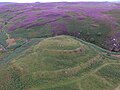 Bewick Hill Moor camp, Northumberland.jpg 4,000 × 3,000; 5.17 MB
-
 Bewick Hillfort, Northumberland.jpg 4,000 × 3,000; 4.95 MB
-
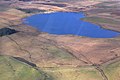 Broomlee Lough aerial.jpg 3,872 × 2,592; 7.48 MB
-
 Carrawburgh Mithraeum aerial.jpg 1,764 × 1,120; 1.49 MB
-
 Crag Lough and Sycamore Gap aerial.jpg 3,772 × 2,244; 5.84 MB
-
 Hadrian's Wall and Housesteads Roman Fort aerial.jpg 3,872 × 2,592; 6.71 MB
-
 Housesteads Roman Fort aerial W.jpg 3,872 × 2,592; 7.76 MB
-
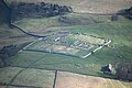 Housesteads Roman Fort aerial.jpg 3,872 × 2,592; 7.56 MB
-
 Housesteads Roman Fort and Broomlee Lough aerial.jpg 3,660 × 2,508; 6.29 MB
-
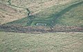
 Milecastle 37 aerial.jpg 2,632 × 1,736; 3.31 MB
-
 Northumberland Hadrian's Wall Aerial 1.jpg 5,472 × 3,648; 15.49 MB
-
 Northumberland Hadrian's Wall Aerial 2.jpg 5,472 × 3,648; 17.03 MB
-
 Northumberland Hadrian's Wall Aerial 3.jpg 5,472 × 3,648; 17.24 MB
-
 Sycamore Gap and Milecastle 39 aerial.jpg 3,872 × 2,592; 7.91 MB
-
 Aerial photo of Alnmouth - geograph.org.uk - 654124.jpg 640 × 480; 83 KB
-

-
 River Tweed - geograph.org.uk - 613782.jpg 640 × 434; 153 KB


