Category:Aerial photographs of Landkreis Vorpommern-Greifswald
Jump to navigation
Jump to search
Districts of Mecklenburg-Western Pomerania:
Subcategories
This category has the following 5 subcategories, out of 5 total.
K
P
Z
Media in category "Aerial photographs of Landkreis Vorpommern-Greifswald"
The following 72 files are in this category, out of 72 total.
-
 11-07-31-Eggesin-by-RalfR-163.jpg 4,288 × 2,848; 4.87 MB
-
 80 KT Silo von Pasewalk - panoramio.jpg 4,000 × 3,000; 5.91 MB
-
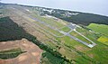
 Aerial image of the Anklam airfield.jpg 5,300 × 2,600; 4.33 MB
-
 Aerial image of the Heringsdorf airport.jpg 5,100 × 3,000; 4.86 MB
-
 Aerial image of the Pasewalk airfield.jpg 4,700 × 2,700; 3.5 MB
-
 Aerial image of the Peenemünde airfield.jpg 5,300 × 3,000; 5.35 MB
-
 Aerial image of the Schmoldow airfield.jpg 5,300 × 2,900; 3.97 MB
-
 Aerial image of the Tutow airfield.jpg 4,700 × 3,100; 6.14 MB
-
 Alt Plestlin Luftaufnahme (2020).jpg 4,056 × 3,040; 5.92 MB
-
 Altwarp aus der Luft.jpg 709 × 351; 69 KB
-
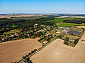
 Anklam Luftaufnahme (2020).jpg 4,056 × 3,040; 5.91 MB
-
 Bergholz, Germany - panoramio (1).jpg 2,816 × 2,112; 994 KB
-
 Bundesarchiv Bild 196-02049, Lassan.jpg 796 × 800; 101 KB
-
 Bundesarchiv Bild 196-02249, Leopoldshagen.jpg 796 × 800; 92 KB
-
 Bundesarchiv Bild 196-02250, Ueckermünde.jpg 798 × 800; 77 KB
-
 Bundesarchiv Bild 196-02349, Ferdinandshof.jpg 791 × 800; 94 KB
-
 Bundesarchiv Bild 196-02350, Eggesin.jpg 800 × 798; 97 KB
-
 Bundesarchiv Bild 196-02351, Rieth.jpg 796 × 800; 101 KB
-
 Bundesarchiv Bild 196-02449, Pasewalk.jpg 800 × 798; 123 KB
-
 Bundesarchiv Bild 196-02450, Krugsdorf.jpg 800 × 798; 98 KB
-
 Bundesarchiv Bild 196-02551, Löcknitz.jpg 735 × 800; 108 KB
-
 Siedlung Karl-Marx-Strasse.jpg 1,429 × 819; 1.4 MB
-
 Eggesin aus der Luft 1997.jpg 1,340 × 1,091; 1.66 MB
-
 Ferdinandshof.JPG 1,920 × 1,280; 401 KB
-
 Friedländer Große Wiese.jpg 8,000 × 6,000; 20.4 MB
-
 Grambin aus der Luft.jpg 709 × 402; 91 KB
-
 Greifswalder Oie aerial photograph 1992-09-18 HBdia03023.jpg 2,385 × 1,564; 1.53 MB
-
 Greifswalder Oie aerial photograph 1992-09-18 HBdia03024.jpg 2,379 × 1,558; 1.47 MB
-
 Gützkow Luftaufnahme (2020).jpg 4,056 × 3,040; 6.26 MB
-
 Gützkow-Peenetal-Torfstiche-0206-luft-001.jpg 1,200 × 960; 205 KB
-
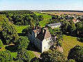 Herrenhaus Alt Plestlin Luftaufnahme (2020).jpg 4,056 × 3,040; 7.8 MB
-
 Hintersee aus der Luft.jpg 591 × 311; 89 KB
-
 Hoppenwalde aus der Luft.jpg 448 × 300; 64 KB
-
 Insel Ruden - geo.hlipp.de - 29769.jpg 640 × 480; 48 KB
-
 Kirche Alt Plestlin Luftaufnahme (2020).jpg 4,056 × 3,040; 7.77 MB
-
 Leopoldshagen aus der Luft.jpg 591 × 494; 86 KB
-
 Lubmin Juli-2012 SL277183 (cropped).JPG 1,334 × 763; 415 KB
-
 Lubmin Juli-2012 SL277183.JPG 3,072 × 2,304; 2.51 MB
-
 Luftaufnahme von Torgelow.JPG 1,600 × 1,066; 421 KB
-
-
 Luftbild Zuckerfabrik Anklam.jpg 1,024 × 683; 151 KB
-
 Moenkebude aus der Luft.jpg 709 × 471; 112 KB
-
 N328 - Peenetal von Jarmen bis Anklam - Vorpommern-GreifswaldII.jpg 4,928 × 3,264; 6 MB
-
 N328 - Peenetal von Jarmen bis Anklam - Vorpommern-GreifswaldIII.jpg 4,928 × 3,264; 6.05 MB
-
 N328 - Peenetal von Jarmen bis Anklam - Vorpommern-GreifswaldIV.jpg 4,928 × 3,264; 5.8 MB
-
 N328 - Peenetal von Jarmen bis Anklam - Vorpommern-GreifswaldV.jpg 4,928 × 3,264; 5.36 MB
-
 N47-AnklamerStadtbruch VorpommernGreifswaldIV.JPG 4,928 × 3,264; 7.95 MB
-
 N47-AnklamerStadtbruch VorpommernGreifswaldV.JPG 4,424 × 3,053; 8.68 MB
-
 Papendorf - panoramio (1).jpg 4,000 × 3,000; 6.08 MB
-
 Papendorf - panoramio (3).jpg 4,000 × 3,000; 5.83 MB
-
 Papendorf - panoramio.jpg 4,000 × 3,000; 6.63 MB
-
 Papendorf Dorfansicht - panoramio.jpg 4,000 × 3,000; 6.23 MB
-
 Pasewalk - panoramio (1).jpg 4,000 × 3,000; 6.66 MB
-
 Pasewalk - panoramio (2).jpg 4,000 × 3,000; 6.81 MB
-
 Pasewalk Innenstadt Blick Richtung Ueckertal - panoramio.jpg 4,000 × 3,000; 5.77 MB
-
 Peene bei Alt Plestlin Luftaufnahme (2020).jpg 4,056 × 3,040; 5.74 MB
-
 Peene bei Anklam Luftaufnahme (2020).jpg 4,056 × 3,040; 5.28 MB
-
 Peenetalbrücke-Jarmen-A20-0206-s12.jpg 1,792 × 1,200; 157 KB
-
 Pensin (Kletzin) Luftaufnahme (2020).jpg 4,056 × 3,040; 6.46 MB
-
 Pomellen Ortsansicht.jpg 4,000 × 3,000; 2.89 MB
-
 Rieth aus der Luft.jpg 1,181 × 741; 188 KB
-
 Schlossberg.jpg 693 × 584; 448 KB
-
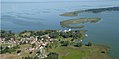
 Swinow an der Peeneeinmündung Luftaufnahme (2020).jpg 4,056 × 3,040; 6.01 MB
-
 Torgelow-Holländerei aus der Luft.jpg 591 × 453; 96 KB
-
 Ueckertal - panoramio.jpg 4,000 × 3,000; 8.49 MB
-
 Usedom anflug.jpg 1,600 × 1,200; 597 KB
-
 Warsin aus der Luft.jpg 709 × 406; 73 KB
-
 Wieck-Gut-2001.jpg 977 × 668; 161 KB
-
 Luftbild Wolgast 18.09.1992.jpg 2,391 × 1,552; 1.82 MB
-
 Peenestrom Wolgast.jpg 1,977 × 1,400; 506 KB
-
 Zemitz Bauerberg Luftbild.JPG 2,491 × 1,623; 1.4 MB
-
 Zusammenfluss von Uecker und Randow bei Eggesin.jpg 1,427 × 982; 1.73 MB


.jpg)

.jpg)
.jpg)


.jpg)

.jpg)


.jpg)

.JPG)


.jpg)
.jpg)


.jpg)
.jpg)

.jpg)
.jpg)

_Luftaufnahme_(2020).jpg)


.jpg)


