Category:Achterom 6, Delft
Jump to navigation
Jump to search
| Object location | | View all coordinates using: OpenStreetMap |
|---|
 | |||||
| Upload media | |||||
| Instance of |
| ||||
|---|---|---|---|---|---|
| Location | Delft, South Holland, Netherlands | ||||
| Heritage designation |
| ||||
 | |||||
|
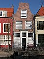
This is a category about rijksmonument number 11705
|
| Address |
|
Media in category "Achterom 6, Delft"
The following 6 files are in this category, out of 6 total.
-
 Delft - Achterom 2.jpg 2,592 × 1,944; 1.99 MB
-
 Delft - Achterom 6.jpg 1,944 × 2,592; 1.49 MB
-
 Delft Achterom 2-6 seen from the south.jpg 4,000 × 6,000; 15.88 MB
-
 Delft Achterom 6.jpg 4,008 × 6,008; 21.21 MB
-
 Gevels - Delft - 20050557 - RCE.jpg 1,200 × 787; 191 KB
-
 Voor- en zijgevel, hoekpand - Delft - 20050556 - RCE.jpg 1,200 × 952; 301 KB


