Category:A865 road (Scotland)
Jump to navigation
Jump to search
road in the Outer Hebrides, Scotland, United Kingdom   | |||||
| Upload media | |||||
| Instance of | |||||
|---|---|---|---|---|---|
| Location | Outer Hebrides, Scotland | ||||
| Transport network |
| ||||
| Has part(s) |
| ||||
 | |||||
Media in category "A865 road (Scotland)"
The following 23 files are in this category, out of 23 total.
-
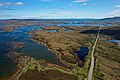 A865 near Aileodair Aerial 01.jpg 5,472 × 3,648; 8.68 MB
-
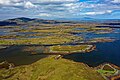 A865 near Aileodair Aerial 02.jpg 5,472 × 3,648; 9.07 MB
-
 A865 near Aileodair Aerial Pan.jpg 17,496 × 6,182; 37.05 MB
-
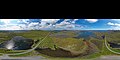 A865 near Aileodair Aerial Pan360.jpg 13,454 × 6,727; 27.57 MB
-
 A865 Road through Balranald. - geograph.org.uk - 443911.jpg 640 × 480; 66 KB
-
 Ardmore, shrine on the A865 - geograph.org.uk - 3210552.jpg 480 × 640; 49 KB
-
 Bayhead from the west - geograph.org.uk - 708777.jpg 640 × 480; 80 KB
-

-
 Drimsdale, A865 with passing places - geograph.org.uk - 3210343.jpg 480 × 640; 54 KB
-
 Loch Bi Causeway - geograph.org.uk - 1435263.jpg 640 × 425; 157 KB
-
 Road Junction near Sruth Mor - geograph.org.uk - 1362959.jpg 640 × 453; 65 KB
-
 Sheepfold in front of Loch an Athain - geograph.org.uk - 939925.jpg 640 × 425; 142 KB
-
 Shrine near Aird Mhor - geograph.org.uk - 1523075.jpg 426 × 640; 207 KB
-

-
 The Borrodale Hotel, Dalabrog - geograph.org.uk - 1364685.jpg 640 × 444; 56 KB
-
 UK road A865.PNG 597 × 184; 10 KB
-
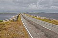
 A865 Road - geograph.org.uk - 444299.jpg 640 × 480; 70 KB
-

-

-
 Junction of A865 and C83 near Solas - geograph.org.uk - 13653.jpg 640 × 480; 59 KB
-
 Telephone Box and Bus Shelter - geograph.org.uk - 445130.jpg 640 × 480; 56 KB
-
 The A865 - geograph.org.uk - 444275.jpg 640 × 480; 73 KB
-
 The A865 Looking West. - geograph.org.uk - 443570.jpg 640 × 480; 84 KB


