Category:70 Whitacre Loop (Capon Bridge, West Virginia)
Jump to navigation
Jump to search
| Object location | | View all coordinates using: OpenStreetMap |
|---|
late 19th-century house, formerly located in Capon Bridge, West Virginia  | |||||
| Upload media | |||||
 | |||||
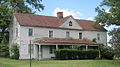
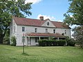
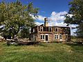
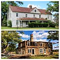
English: 70 Whitacre Loop — a late 19th-century house, formerly located in Capon Bridge, west of the Cacapon River, in West Virginia.
- The residence was demolished in October 2014.
Media in category "70 Whitacre Loop (Capon Bridge, West Virginia)"
The following 8 files are in this category, out of 8 total.
-
 70 Whitacre Loop Capon Bridge WV 2013 07 14 01.JPG 3,648 × 2,048; 2.2 MB
-
 70 Whitacre Loop Capon Bridge WV 2013 07 14 02.JPG 3,648 × 2,048; 2.03 MB
-
 70 Whitacre Loop Capon Bridge WV 2013 07 14 03.JPG 3,648 × 2,736; 2.88 MB
-
 70 Whitacre Loop Capon Bridge WV 2013 07 14 04.JPG 3,648 × 2,736; 3.04 MB
-
 70 Whitacre Loop Capon Bridge WV 2014 10 05 01.JPG 3,264 × 2,448; 4.26 MB
-
 70 Whitacre Loop Capon Bridge WV 2014 10 05 02.JPG 3,264 × 2,448; 4.27 MB
-
 70 Whitacre Loop Capon Bridge WV 2014 10 05 03.JPG 3,264 × 2,448; 3.92 MB
-
 70 Whitacre Loop Capon Bridge WV 2014 10 05 04.JPG 1,936 × 1,936; 1.11 MB


Categories:
- Capon Bridge, West Virginia
- Houses in Hampshire County, West Virginia
- 19th-century houses in West Virginia
- Demolished houses in the United States
- White houses in the United States
- White buildings in the United States
- Victorian architecture in West Virginia
- Wooden buildings in Hampshire County, West Virginia