Category:20th-century maps of Alsace
Jump to navigation
Jump to search
Administrative regions and territorial collectivity of Metropolitan France (‡ since start of 2016):
Corsica
Former administrative regions of Metropolitan France (until end of 2015):
Alsace
Overseas departments and regions: Guadeloupe · Martinique · French Guiana
Corsica
Former administrative regions of Metropolitan France (until end of 2015):
Alsace
Overseas departments and regions: Guadeloupe · Martinique · French Guiana
Subcategories
This category has the following 3 subcategories, out of 3 total.
Media in category "20th-century maps of Alsace"
The following 13 files are in this category, out of 13 total.
-

-
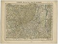
 Vosges et Alsace. 1 - 250 000 P. Bineteau delint - btv1b85934715.jpg 8,075 × 11,616; 18.4 MB
-
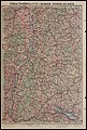
 Vosges (Section Nord). Basse Alsace. Vosges (Section Sud). Haute Alsace - btv1b84461842 (1 of 2).jpg 10,486 × 8,040; 15.07 MB
-
 Vosges (Section Nord). Basse Alsace. Vosges (Section Sud). Haute Alsace - btv1b84461842 (2 of 2).jpg 10,510 × 8,061; 14.95 MB
-

-
 Die deutsche Westgrenze - btv1b84589053.jpg 6,874 × 10,531; 12.98 MB
-
 Alsace, Lorraine, Luxembourg. Bords du Rhin - btv1b531215707.jpg 7,782 × 11,554; 17.86 MB
-
 Chemins de fer. Alsace, Lorraine, Palatinat - btv1b531215635.jpg 8,134 × 10,552; 11.15 MB
-
 Alsace-Lorraine, Luxembourg, Bords du Rhin - btv1b53121320d.jpg 7,758 × 11,532; 17.6 MB
-
 Carte Campbell no 23 Alsace-Bords du Rhin - btv1b10224810n.jpg 7,986 × 11,795; 18.05 MB
-
 Nouvelle carte de l'Alsace-Lorraine et du territoire de la Sarre - btv1b10224817s.jpg 8,642 × 10,926; 17.42 MB
-
 Review of reviews and world's work (1890) (14586990167).jpg 1,894 × 2,916; 531 KB
-
 USA-E-Riviera-34.jpg 1,200 × 1,010; 416 KB
.jpg)

._Basse_Alsace._Vosges_(Section_Sud)._Haute_Alsace_-_btv1b84461842_(1_of_2).jpg)
._Basse_Alsace._Vosges_(Section_Sud)._Haute_Alsace_-_btv1b84461842_(2_of_2).jpg)


_(14586990167).jpg)
