Category:2022 maps of California
Jump to navigation
Jump to search
Media in category "2022 maps of California"
The following 10 files are in this category, out of 10 total.
-
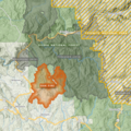
 2022 Mosquito Fire map 1.png 3,540 × 2,500; 14.41 MB
-
 2022 Oak Fire map 1.png 1,300 × 1,300; 3.27 MB
-
 BART system map effective February 2022.png 4,167 × 3,347; 1.3 MB
-
 Drought Monitor, California May 17, 2022.png 1,056 × 816; 58 KB
-
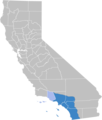
 Map of the Californian Deserts region of California.png 1,124 × 1,327; 184 KB
-
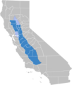 Map of the Central Valley region of California.png 1,124 × 1,327; 185 KB
-
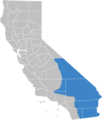
 Map of the South Coast region of California.png 1,124 × 1,327; 183 KB
-
 MonkeyPox California 09-25-2022.png 1,346 × 1,498; 283 KB
-
 Muni Metro map (2022-02-19).gif 1,140 × 1,140; 173 KB
-
 Public Information Map of the Mosquito Fire 10-24-2022.jpg 7,249 × 5,437; 4.69 MB


.gif)
