Category:2020 U.S. presidential election maps by state, Democratic primary
Jump to navigation
Jump to search
Subcategories
This category has the following 2 subcategories, out of 2 total.
Media in category "2020 U.S. presidential election maps by state, Democratic primary"
The following 83 files are in this category, out of 83 total.
-
 2020 Alabama Democratic Presidential Primary election by county.svg 810 × 810; 42 KB
-
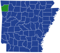
 2020 Arkansas Democratic Presidential Primary election by county.svg 810 × 709; 45 KB
-

-
 2020 Colorado Democratic Presidential Primary election by county.svg 810 × 589; 44 KB
-

-
 2020 Democratic Presidential primary election in Massachusetts by municipalities.svg 2,200 × 1,400; 1.62 MB
-

-
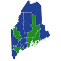
 2020 Maine Democratic Presidential Primary election by county.svg 810 × 810; 43 KB
-

-

-
 2020 New York Democratic Presidential Primary election by county.svg 810 × 621; 67 KB
-

-
 2020 Oklahoma Democratic Presidential Primary election by county.svg 810 × 404; 36 KB
-

-

-

-

-

-
 2020 U.S. Virgin Islands Democratic Primary.svg 512 × 417; 28 KB
-

-

-

-
-

-

-

-

-

-

-
 Democrats Abroad's Global Presidential Primary Results by Country, 2020.svg 2,560 × 1,134; 1.01 MB
-
-

-
 Hawaii Democratic presidential primary election results by county, 2020.svg 1,052 × 614; 2.12 MB
-

-

-

-

-

-

-

-

-

-
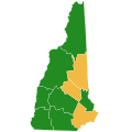
 Maine Democratic Presidential Caucuses Election Results by County, 2020.svg 800 × 1,257; 296 KB
-
-

-

-

-

-

-

-

-

-

-

-

-

-

-
-

-

-

-

-

-

-

-

-

-

-

-

-

-

-

-

-

-

-

-

-

-

-

-

-


,_2020.svg)
,_2020.svg)
,_2020.svg)


,_2020.svg)
,_2020.svg)
,_2020.svg)


