Category:1 Castle Street, Liverpool
Jump to navigation
Jump to search
| Object location | | View all coordinates using: OpenStreetMap |
|---|
Liverpool, Merseyside, L2  | |||||
| Upload media | |||||
| Instance of | |||||
|---|---|---|---|---|---|
| Location | Liverpool, Merseyside, North West England, England | ||||
| Heritage designation |
| ||||
 | |||||
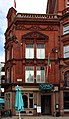
Former bank building on the corner of Dale Street, 1880s by E. Salomons; now an Italian-style restaurant.
Media in category "1 Castle Street, Liverpool"
The following 5 files are in this category, out of 5 total.
-
 1 Castle Street 1.jpg 3,999 × 3,455; 6.04 MB
-
 1 Castle Street 2.jpg 2,868 × 4,944; 6.53 MB
-
 1 Castle Street, Liverpool.jpg 1,984 × 1,488; 646 KB
-
 Castle Street, Liverpool 10.jpg 1,984 × 1,488; 685 KB
-
 Liverpool 40859.jpg 2,866 × 2,448; 3.99 MB


