Category:1 - 7 Wavertree Road
Jump to navigation
Jump to search
| Object location | | View all coordinates using: OpenStreetMap |
|---|
building in Liverpool, Merseyside, UK  | |||||
| Upload media | |||||
| Instance of | |||||
|---|---|---|---|---|---|
| Location | Liverpool, Merseyside, North West England, England | ||||
| Heritage designation |
| ||||
 | |||||
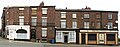
Group of 1830s shops, houses and a pub, Grade II listed, which includes 30 Marmaduke Street.
Subcategories
This category has only the following subcategory.
R
- Rose Vaults, Wavertree Road (4 F)
Media in category "1 - 7 Wavertree Road"
The following 4 files are in this category, out of 4 total.
-
 1 - 3 Wavertree Road.jpg 4,410 × 3,429; 6.24 MB
-
 1 - 5 Wavertree Road.jpg 4,560 × 3,400; 6.63 MB
-
 1 - 7 Wavertree Road.jpg 8,042 × 3,179; 10.99 MB
-
 30 Marmaduke Street.jpg 3,832 × 3,560; 6.85 MB


