Category:1 - 6 Mortimer Street, Birkenhead
Jump to navigation
Jump to search
| Object location | | View all coordinates using: OpenStreetMap |
|---|
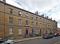
grade II* listed terrace of town houses in Birkenhead, Wirral, Merseyside, UK  | |||||
| Upload media | |||||
| Instance of | |||||
|---|---|---|---|---|---|
| Location | Birkenhead, Wirral, Merseyside, North West England, England | ||||
| Heritage designation |
| ||||
 | |||||
Media in category "1 - 6 Mortimer Street, Birkenhead"
The following 4 files are in this category, out of 4 total.
-
 1 - 6 Mortimer Street, Birkenhead.jpg 4,307 × 3,169; 15.84 MB
-
 1-6 Mortimer Street, Birkenhead (2).jpg 4,608 × 3,456; 3.43 MB
-
 1-6 Mortimer Street, Birkenhead.jpg 4,608 × 3,456; 3.42 MB
-
 Italian consulate, Birkenhead 1.JPG 2,736 × 3,648; 3.49 MB
.jpg)

