Category:1 - 19 Canning Street
Jump to navigation
Jump to search
| Object location | | View all coordinates using: OpenStreetMap |
|---|
building in Liverpool, Merseyside, UK  | |||||
| Upload media | |||||
| Instance of | |||||
|---|---|---|---|---|---|
| Location | Liverpool, Merseyside, North West England, England | ||||
| Street address |
| ||||
| Heritage designation |
| ||||
 | |||||
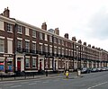
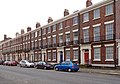
Grade II listed terrace of 10 houses dating to the 1830s.
Media in category "1 - 19 Canning Street"
The following 2 files are in this category, out of 2 total.
-
 1 - 19 Canning Street 1.jpg 3,593 × 2,978; 3.77 MB
-
 1 - 19 Canning Street 2.jpg 4,422 × 3,108; 5.78 MB
