Category:1 - 10 Gambier Terrace
Jump to navigation
Jump to search
| Object location | | View all coordinates using: OpenStreetMap |
|---|
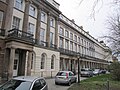
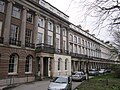
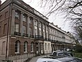
Grade II* listed terrace of houses in Liverpool, UK  | |||||
| Upload media | |||||
| Instance of | |||||
|---|---|---|---|---|---|
| Location | Liverpool, Merseyside, North West England, England | ||||
| Located on street | |||||
| Architect | |||||
| Heritage designation |
| ||||
 | |||||
Subcategories
This category has only the following subcategory.
2
- 2 Canning Street, Liverpool (3 F)
Media in category "1 - 10 Gambier Terrace"
The following 18 files are in this category, out of 18 total.
-
 1 - 10 Gambier Terrace 2021-1.jpg 4,365 × 3,320; 21.32 MB
-
 1 - 10 Gambier Terrace 2021-2.jpg 4,336 × 3,310; 19.25 MB
-
 1 - 10 Gambier Terrace pano.jpg 5,820 × 1,263; 7.02 MB
-
 Gambier Terrace 2017-1.jpg 3,568 × 3,491; 6.39 MB
-
 Gambier Terrace 2017-2.jpg 4,527 × 3,515; 8.12 MB
-
 Gambier Terrace North end.JPG 1,232 × 1,840; 371 KB
-
 Gambier Terrace, Liverpool (10).JPG 4,320 × 3,240; 3.56 MB
-
 Gambier Terrace, Liverpool (11).JPG 4,320 × 3,240; 3.68 MB
-
 Gambier Terrace, Liverpool (12).JPG 4,320 × 3,240; 3.25 MB
-
 Gambier Terrace, Liverpool (13).JPG 4,320 × 3,240; 3.67 MB
-
 Gambier Terrace, Liverpool (14).JPG 4,320 × 3,240; 3.87 MB
-
 Gambier Terrace, Liverpool (15).JPG 4,320 × 3,240; 3.89 MB
-
 Gambier Terrace, Liverpool (5).JPG 4,320 × 3,240; 3.14 MB
-
 Gambier Terrace, Liverpool (6).JPG 4,320 × 3,240; 2.94 MB
-
 Gambier Terrace, Liverpool (7).JPG 3,240 × 4,320; 2.91 MB
-
 Gambier Terrace, Liverpool (8).JPG 4,320 × 3,240; 3.49 MB
-
 Gambier Terrace, Liverpool (9).JPG 4,320 × 3,240; 3.47 MB
-
 Gambier Terrace, Liverpool.jpg 465 × 640; 177 KB


.JPG)
.JPG)
.JPG)
.JPG)
.JPG)
.JPG)
.JPG)
.JPG)
.JPG)
.JPG)
.JPG)
