Category:1926 in Boston
Jump to navigation
Jump to search
Most populous urban areas of the world: Ankara [TR] · Atlanta [US] · Bangkok [TH] · Barcelona [ES] · Beijing [CN] · Boston [US] · Buenos Aires [AR] · Cairo [EG] · Chicago [US] · Detroit [US] · Dhaka [BD] · Guangzhou [CN] · Guatemala City [GT] · Hanoi [VN] · Hong Kong [CN] · Houston [US] · Hyderabad [IN] · Istanbul [TR] · Jakarta [ID] · London [GB] · Los Angeles [US] · Madrid [ES] · Medan [ID] · Mexico City [MX] · Miami [US] · Milan [IT] · Moscow [RU] · Mumbai [IN] · New York City [US] · Osaka [JP] · Paris [FR] · Philadelphia [US] · Rio de Janeiro [BR] · Saint Petersburg [RU] · San Francisco [US] · São Paulo [BR] · Semarang [ID] · Seoul [KR] · Shanghai [CN] · Singapore [SG] · Taipei [TW] · Tehran [IR] · Tokyo [JP] · Toronto [CA] · Washington, D.C. [US]
State capitals of the United States: Annapolis [MD] · Atlanta [GA] · Boston [MA] · Columbus [OH] · Harrisburg [PA] · Indianapolis [IN] · Little Rock [AR] · Saint Paul [MN] · Salt Lake City [UT] · Federal district: Washington, D.C. [DC] · Insular area of the United States
- 100 most populous cities of the United States
- 1–25
- Boston
- Chicago
- Columbus
- Houston
- Indianapolis
- Los Angeles
- New York City
- Philadelphia
- San Francisco
- Seattle
- Washington, D.C.
- 26–50
- Atlanta
- Baltimore
- Detroit
- Las Vegas
- Memphis
- Virginia Beach
- 51–75
- Jersey City
- Newark
- New Orleans
- Pittsburgh
- Saint Paul
- Tampa
- 76–100
- Fort Wayne
- Reno
- St. Petersburg
1926 in Boston
Français : 1926 à Boston
Русский: 1926 год в Бостоне
Subcategories
This category has only the following subcategory.
Media in category "1926 in Boston"
The following 22 files are in this category, out of 22 total.
-
 1926 BERy rapid transit map.png 3,500 × 3,927; 18.48 MB
-
 1926 BERy system map.png 3,500 × 6,182; 28.48 MB
-
 1926 Boston Elevated Railway rapid transit map.jpg 2,448 × 2,721; 524 KB
-
 1926 BostonHarbor map CityPlanningBoard BPL.png 557 × 717; 607 KB
-
 1926 Cornhill map Boston BPL12989 detail.png 809 × 713; 953 KB
-
 Annual report of the trustees (IA annualreportoftr1926bost).pdf 1,081 × 1,777, 170 pages; 7.98 MB
-
 Boston Elevated Railway Guide and Information Book 1926 cover.jpg 2,451 × 2,718; 815 KB
-
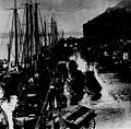 Boston Fish Pier (1926).jpg 2,854 × 2,810; 1,018 KB
-
 Charles G. Keene August 1926 (a).jpg 1,522 × 2,031; 539 KB
-
 Chicago Tribune Sun Nov 28 1926 -122.jpg 5,596 × 7,394; 4.8 MB
-
 Dorchester Extension portal construction from Dorchester Avenue bridge, October 1926.jpg 4,849 × 3,625; 2.29 MB
-
 Field's Corner station, section 2 field office, September 1926.jpg 4,880 × 3,594; 2.65 MB
-
 Fields Corner station, February 1926.jpg 3,386 × 2,631; 674 KB
-
 Harrison gray otis house.jpg 1,130 × 1,162; 148 KB
-

-
 Map of the city of Boston Massachusetts (3886420075).jpg 1,796 × 2,000; 2.63 MB
-
 Moving Crescent station, October 1926.jpg 3,376 × 2,519; 636 KB
-
 Oneida fc formation.jpg 2,276 × 2,690; 255 KB
-
 Repairs to Atlantic Avenue station headhouse, 1926.jpg 2,756 × 1,683; 1.24 MB
-
 Ritz Carlton under construction (15712532594).jpg 6,111 × 4,931; 3.38 MB
-

-
 The Vision (1926) - 4.jpg 980 × 752; 206 KB


.jpg)
.jpg)


.jpg)


.jpg)
.jpg)
_-_4.jpg)