Category:1914 maps of Canada
Jump to navigation
Jump to search
Countries of North America: Canada · Mexico · United States of America‡
‡: partly located in North America
‡: partly located in North America
| ← 1910 1911 1912 1913 1914 1915 1916 1917 1918 1919 → |
English: Maps of Canada from 1914 or related to Canada in 1914
Français : Les cartes du Canada de 1914 ou se rapportant au Canada en 1914
Subcategories
This category has the following 2 subcategories, out of 2 total.
O
- 1914 maps of Ontario (6 F)
Q
Media in category "1914 maps of Canada"
The following 8 files are in this category, out of 8 total.
-

-

-

-
 Hudsonbayrailway1.jpg 500 × 319; 25 KB
-
 Map of the Dominion of Canada (14006567941).jpg 2,000 × 1,507; 3.17 MB
-
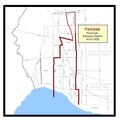 Parkdale provincial electoral district 1914–1926.pdf 1,658 × 1,656; 45 KB
-
 Sessional papers of the Dominion of Canada 1914 (1914) (14595714367).jpg 3,264 × 2,198; 386 KB
-

_(1914)_(14597345740).jpg)
_(1914)_(14597546817).jpg)
_(1914)_(14597550617).jpg)

.jpg)
_(14595714367).jpg)
_(14778976771).jpg)