Category:1893 maps of Massachusetts
Jump to navigation
Jump to search
States of the United States: California · Florida · Georgia · Hawaii · Idaho · Illinois · Indiana · Iowa · Kansas · Kentucky · Louisiana · Maine · Massachusetts · Michigan · Minnesota · Mississippi · Missouri · Montana · New Hampshire · New Mexico · New York · North Carolina · North Dakota · Ohio · Oregon · Pennsylvania · South Carolina · South Dakota · Tennessee · Texas · Utah · Virginia · Washington · West Virginia · Wisconsin · Wyoming – Washington, D.C.
| ← 1890 1891 1892 1893 1894 1895 1896 1897 1898 1899 → |
Subcategories
This category has the following 2 subcategories, out of 2 total.
B
- 1893 maps of Boston (5 F)
C
Media in category "1893 maps of Massachusetts"
The following 22 files are in this category, out of 22 total.
-
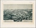 1893 bird's eye view map of Concord Junction, Massachusetts.jpg 10,176 × 8,000; 6.95 MB
-
 1893 bird's eye view map of Haverhill, Massachusetts.jpg 10,288 × 7,448; 11.86 MB
-
 1893 bird's eye view map of Readville, Massachusetts.jpg 6,528 × 5,044; 4.49 MB
-
 1893 map of parks of the metropolitan district of Boston.jpg 8,712 × 7,984; 9.06 MB
-
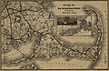
 1893 New Haven Railroad South Shore map.png 2,106 × 3,500; 13.43 MB
-
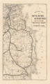
 1893 Sectional Map of New York, New Haven and Hartford Railroad, Eastern District, Cape Cod.jpg 4,670 × 3,036; 17.25 MB
-

-
 A guide-book to Norumbega and Vineland (1893) (14591682470).jpg 1,888 × 3,428; 526 KB
-
 Free public libraries of Massachusetts (9135716775).jpg 800 × 504; 117 KB
-
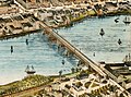 Haverhill Bridge and station on 1893 bird's eye view map.jpg 1,630 × 1,211; 459 KB
-
 Haverhill station on 1893 bird's eye view map.jpg 1,241 × 838; 285 KB
-
 Haverhill, Massachusetts. LOC 75694577.jpg 10,831 × 8,073; 17.14 MB
-
 Ipswich, Mass. (2674476744).jpg 2,000 × 1,571; 2.2 MB
-
 Ipswich, Mass. - incorporated 1634 LOC 2005628431.jpg 8,185 × 5,535; 4.97 MB
-
 Ipswich, Mass. - incorporated 1634 LOC 2005628431.tif 8,185 × 5,535; 129.62 MB
-

-

-
 Nantucket Shoals, Mass. (3120016807).jpg 1,639 × 2,000; 2.47 MB
-
 No. Chelmsford, Mass. (2675911238).jpg 2,000 × 1,578; 2 MB
-
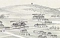 Readville stations on 1893 bird's eye view map.jpg 722 × 456; 94 KB
-
 The public schools of Massachusetts (9137936728).jpg 799 × 512; 127 KB
-
 Three Rivers, Mass. (2674740321).jpg 2,000 × 1,531; 2.94 MB


_(14591682470).jpg)
.jpg)


.jpg)

.jpg)

.jpg)
.jpg)

.jpg)
.jpg)