Category:1879 maps of Massachusetts
Jump to navigation
Jump to search
States of the United States: California · Florida · Illinois · Indiana · Louisiana · Maryland · Massachusetts · Michigan · Montana · Nevada · New York · Oklahoma · Oregon · Pennsylvania · Texas – Washington, D.C.
| ← 1870 1871 1872 1873 1874 1875 1876 1877 1878 1879 → |
Subcategories
This category has the following 2 subcategories, out of 2 total.
B
Media in category "1879 maps of Massachusetts"
The following 40 files are in this category, out of 40 total.
-

-
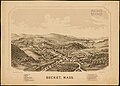 1879 bird's eye view map of Becket, Massachusetts.jpg 7,952 × 5,688; 4.94 MB
-
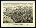 1879 birds-eye map of Beverly, Massachusetts.jpg 7,337 × 5,848; 9.74 MB
-
-
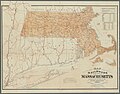
 1879 Railroad Map Massachusetts.jpg 9,872 × 6,416; 22.35 MB
-
 Balloon view, Provincetown to Boston LOC 2016586529.jpg 5,538 × 3,672; 2.93 MB
-
 Balloon view, Provincetown to Boston LOC 2016586529.tif 5,538 × 3,672; 58.18 MB
-
 Balloon view--Provincetown to Boston (2675011406).jpg 2,000 × 1,253; 2.2 MB
-

-
 Foxborough, Mass. (2674464726).jpg 2,000 × 1,680; 2.72 MB
-
 Foxborough, Mass. 1879. LOC 74693248.jpg 8,272 × 6,320; 10.25 MB
-
 Hyde Park (B&P) station on 1879 bird's eye view map.jpg 489 × 331; 39 KB
-
 Hyde Park (NY&NE) station on 1879 bird's eye view map.jpg 350 × 272; 25 KB
-
 Manufacturing center of Lynn, Mass.(2675939038).jpg 8,504 × 7,008; 43.54 MB
-
 Maynard, Mass. (2674537982).jpg 2,000 × 1,634; 2.74 MB
-
 Maynard, Mass. 1879. LOC 75694589.jpg 8,960 × 6,944; 10.2 MB
-
 Monson, Mass. (2673686907).jpg 2,000 × 1,465; 2.26 MB
-
 Monson, Mass. 1879. LOC 74693243.jpg 8,352 × 6,464; 8.3 MB
-
 Plan of Middlesex County, Massachusetts (2674373783).jpg 2,000 × 1,349; 1.91 MB
-

-
 Rail road & township map of Massachusetts, published at the Boston Map Store, 1879. LOC 98688495.tif 9,872 × 6,416; 181.21 MB
-
 Readville stations on 1879 bird's eye view map.jpg 674 × 454; 80 KB
-
 Stoughton, Mass. (2674553928).jpg 2,000 × 1,581; 2.58 MB
-
 View of Beverly, Mass. 1879. LOC 2013591355.jpg 8,218 × 6,348; 9.17 MB
-
 View of East Boston, Mass. (2674931299).jpg 2,000 × 1,594; 2.61 MB
-
 View of East Cambridge, Mass., 1879 (2674960185).jpg 2,000 × 1,604; 2.71 MB
-
 View of Franklin, Mass. (2673646413).jpg 2,000 × 1,583; 2.66 MB
-
 View of Hyde Park, Mass., 1879 G3764.B6-2H9A3 1879B35.jpg 7,832 × 5,896; 7.48 MB
-
 View of Mansfield, Mass. (2674541320).jpg 2,000 × 1,554; 2.41 MB
-
 View of Nantasket Beach, looking s.e. from Sagamore Hill. LOC 75694592.jpg 8,688 × 5,776; 10.44 MB
-
 View of Nantasket Beach, looking s.e. from Sagamore Hill. LOC 75694592.tif 8,688 × 5,776; 143.57 MB
-
 View of Nantasket Beach, looking S.E. from Sagamore Hill. LOC 78692624.jpg 8,839 × 5,562; 11.52 MB
-
 View of Nantasket Beach, looking S.E. from Sagamore Hill. LOC 78692624.tif 8,839 × 5,562; 140.66 MB
-
 View of Nantasket Beach. LOC 75694591.jpg 12,151 × 8,071; 19.41 MB
-
 View of Nantasket Beach. LOC 75694591.tif 12,151 × 8,071; 280.58 MB
-
 View of Palmer, Mass. LOC 88690615.jpg 8,368 × 6,608; 11.1 MB
-
 View of Warren, Mass. (2673731009).jpg 2,000 × 1,584; 2.29 MB
-
 View of Warren, Mass. - 1879 LOC 87694493.jpg 8,080 × 6,176; 10.26 MB
-
 View of Watertown, Mass. (2675931678).jpg 2,000 × 1,592; 2.84 MB
-
 View of Watertown, Mass., 1879. LOC 2003620064.jpg 6,923 × 5,384; 7.17 MB
,_with_illustrations_and_biographical_sketches_of_some_of_its_prominent_men_and_pioneers_(by_other_authors)%27_(11128225334).jpg)


.jpg)

.jpg)

_station_on_1879_bird%27s_eye_view_map.jpg)
_station_on_1879_bird%27s_eye_view_map.jpg)
.jpg)
.jpg)

.jpg)

.jpg)


.jpg)

.jpg)
.jpg)
.jpg)

.jpg)


.jpg)

.jpg)
