Category:1871 maps of Boston
Jump to navigation
Jump to search
Media in category "1871 maps of Boston"
The following 16 files are in this category, out of 16 total.
-
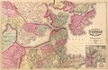 1871 Boston map by H. F. Walling & Orm Gray.jpg 8,552 × 5,531; 14.07 MB
-
 1871Boston map HaymarketSquare area.jpg 527 × 339; 289 KB
-
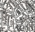
 1871Boston map SchoolSt area.jpg 384 × 256; 156 KB
-
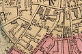
 1871Boston map ScollaySquare area.jpg 438 × 435; 309 KB
-

-
 Boston 1871 map AmericanHouse HanoverSt detail.jpg 541 × 454; 266 KB
-
 Boston 1871 map RevereHouse detail.jpg 589 × 421; 253 KB
-
 Boston 1871 PembertonSquare area.jpg 414 × 707; 329 KB
-
 Boston 1871 Walling BrattleStreet area.jpg 445 × 407; 217 KB
-
 Boston 1871 Walling LowellStreet area.jpg 857 × 625; 592 KB
-
 Boston Street Map, 1871.jpg 4,976 × 3,311; 7.52 MB
-
 New map of Boston (2674727431).jpg 2,000 × 1,510; 2.91 MB
-
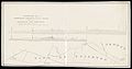
 Plan and profile of the proposed alterations of the Brighton Branch Railroad.jpg 9,589 × 3,446; 4.34 MB
-
 Plan no II of land of George D. Welles situated in ward 16 Boston (2675511768).jpg 2,000 × 1,276; 1.55 MB
-

-
 Survey for a proposed branch railroad between Allston and Newton.jpg 8,901 × 4,700; 3.86 MB


.jpg)


.jpg)
.jpg)
.jpg)
