Category:1840s maps of Persia, Afghanistan and Baluchistan
Jump to navigation
Jump to search
English: This category collects maps showing the full ensemble of Persia, Afghanistan and Baluchistan in the 1840s
Media in category "1840s maps of Persia, Afghanistan and Baluchistan"
The following 15 files are in this category, out of 15 total.
-

-
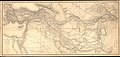
 1842 map of Central Asia by John Arrowsmith.jpg 17,686 × 12,299; 26.82 MB
-
 Barclay's Dictionary Persia, Cabool and Baloochistan.jpg 5,929 × 4,813; 21.95 MB
-
 Westliches Hochasien.jpg 5,495 × 4,459; 8.1 MB
-
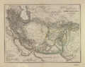
 1846 map of Iran and Turkestan.jpg 9,534 × 8,000; 15.69 MB
-
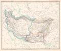
 1846 map of Persia and neighbours by Weiland.jpg 15,919 × 12,709; 26.67 MB
-

-

-
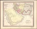
 Persia Arabia etc. LOC 2013593035.jpg 7,028 × 5,533; 6.08 MB
-
 Persia Arabia etc. LOC 2013593035.tif 7,028 × 5,533; 111.25 MB
-
-
 Plateau von Iran Platt 1848.pdf 2,864 × 2,395; 661 KB
-
-
 Perse, Kaboul, Beloutchistan et Pendjab LOC 2006627705.jpg 4,878 × 3,736; 3.66 MB
-
 Perse, Kaboul, Beloutchistan et Pendjab LOC 2006627705.tif 4,878 × 3,736; 52.14 MB


